Dunolly Cycle Tracks


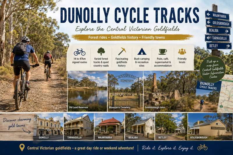
Located in the Central Victorian goldfields, the Dunolly Cycle Tracks are a series of signed forest roads and tracks varying in length between 14 to 47 kilometres. The area is rich in box ironbark fauna and flora, fascinating goldfields history and wonderful cycling conditions. Routes pass through the old gold towns of Dunolly, Tarnagulla, Bealiba, Waanyarra, Betley and Goldsborough. Attractions include quiet roads and tracks, a supermarket, pubs, cafe, caravan parks, motel, B&B and friendly locals.
Maps
There is a map of the Dunolly Cycle Tracks available from Central Goldfields Visitor Information Centre for a small cost. A digital copy of this map for download is available at Dunolly Cycle Map.
Waanyarra
Distance: 27km return to Town Hall
• moderate climbs
• mainly bush tracks
• includes bush camping ground
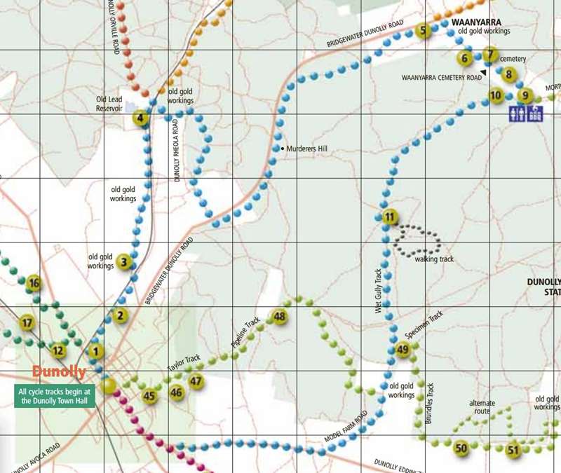
This is a wonderful ride with a variety of features including the old gold mining site of Waanyarra. The ride out of town follows a bush track beside the railway line to a quiet sealed road leading to the Old Lead Reservoir. This was at one time the water supply for Dunolly. Follow the blue signs over the railway line to Sporting Flat Road, a bush track through the forest to the Dunolly Tarnagulla Road. A hundred metres along here you turn into the bush and then take a signed track that runs parallel to the main road all the way to Waanyarra up over Murders Hill. At Waanyarra there is a wonderful cemetery cared for by the "Friends of Waanyarra" . There's also the Waanyarra Recreation Site with barbeque, shelter, water, camping area and toilets. Its a great spot to camp overnight. The ride back involves continuing up the Waanyarra Road to the sign taking you right just a short distance from the campsite. Then its back along a series of tracks including Wet Gully Track with a long gentle up then rewarding down slope to meet the Dunolly Eddington sealed and back to Dunolly.
1 The Old Lead Dredge Hole. Worked from 1907 to 1912. Rich ground dredged to about 45' depth. Hydraulic sluicing with water from the Old Lead Reservoir.
2 An embankment supporting the pipeline supplied the water for the Old Lead Dredge.
3 The Old Lead Diggings. Part of the main gold rush in 1856. These diggings were responsible for the growth of Dunolly.
4 Old Lead Reservoir established 1860, though pipes not connected to Dunolly until 1887.
5 Jones Creek Diggings. Very rich gold bearing area with many large nuggets.
6 Marker indicating a site believed to be an early goldfields burial ground.
7 Waanyarra Cemetery (c.1858) maintained by the Friends and Families of Waanyarra group.
8 A grave beside the road, believed by some to be the grave of a prostitute refused burial within the cemetery.
9 Waanyarra Recreation Site
CAMPING FACILITIES AVAILABLE.
Cogswells Crossing at the bottom of Jones Creek. James Cogswell was a gunsmith who operated his shop here.
10 Site of an early gold rush in 1856.
11 Dam at Shoots Lead, site of finding of a 475oz nugget by Henry Davey in 1872.
Goldsborough
Distance: 14km return to Town Hall
• reasonably easy forest ride
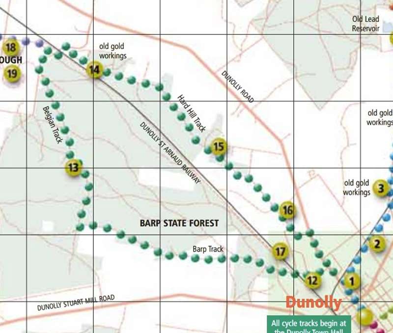
Goldsborough is a small community with some interesting relics of commercial goldming of 100 years ago including features marked on the cycle track map. The ride is gently undulating over unmade bush tracks through box ironbark forest. The Bealiba range offers a great walking opportunities with impressive views of the surounding countryside.
12 Former site of Whittakers lemonade factory established 1863. The building has gone but two wells are visible. The second house in Ravens Lane is the former manager's house.
13 The Belgian Reef. Site of extensive mine workings. Close to the track there is the remains of a circular Chilean mill on the east side, and on the west, a vat used to extract gold with cyanide from mine tailings.
14 To the north of the track is Surface Hill which was worked in the 1860s.
15 Hard Hill is an old riverbed; the site of a large gold rush in 1854. There was a township around this Hill, in an arc on the south side.
16 Site of the fourth location of Dunolly township in early 1856. Small rise 100m to the east was the site of the town market. North of the fence were a series of brothels, and across to the south on high ground was the police camp (1856 to 1859).
17 The old Dunolly Cemetery established in 1856 was replaced in early 1864 with the current cemetery site.
Bealiba
Distance: 34km as marked (47km return to Town Hall)
• forest ride, mostly gentle
• short rocky climb on Boundary Track
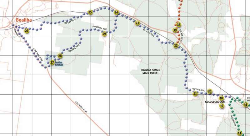
The ride to Bealiba is an extension of the ride to Goldsborough. To Bealiba, the track surface is unmade and gently undulates through box ironbark forest. The section to the Bealiba Reservoir is sealed and then unmade road. From the reservoir, the section along Boundary track is rougher and there are some short steeper rises before rejoining Ponderosa track. This track passes trough two gates which should be left as you find them either open or (normally) closed. Alternatively you can retrace your wheel tracks from Bealiba or take the relatively quiet sealed road back to Dunolly.
18 The shaft for the Goldsborough company. To the south, and well in from the road, is the Queens Birthday Mine. At one stage this was the largest mine in Victoria.
19 Powder magazine for the Kings Birthday Mine probably built in 1870s or 1880s. Solid triple-brick construction; had a solid steel door and galvanised iron roof with framework loosely attached. If the magazine exploded, the roof would come off in one piece.
20 Goldsborough State School built 1882 and closed 1959. The school was not in town because of the constant noise of mine batteries.
21 Small dam beside road, known as a camping place for aborigines of the Beal Balug clan from Bealiba.
22 Red Gate Crossing on the Dunolly-Bealiba railway line; built 1878. The line was fenced and there was a house here for the gatekeeper who would open and close a gate for passing traffic.
23 Misers Gully – site of unsuccessful test holes.
24 Gladstone Siding, a small railway siding with gate and gatekeeper's house, operational to early 1900s.
25 Large stand of she-oaks.
26 Bealiba Cemetery.
27 Bealiba Reservoir.
28 Catchment channel for the Bealiba Reservoir.
29 Cement crossing in Long Gully. To the south about 50m is the Bealiba Maternity Tree.
Moliagul
Distance: 18km as marked (35km return to Town Hall)
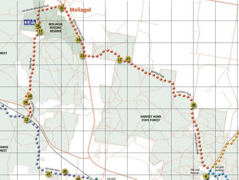
• reasonably gentle ride mainly through forest
Follow the Waanyarra signs (Blue) to the Old Lead Reservoir and then head along the Dunolly Orville road following the red signs. After Salvation Track this ride is a great ride through box ironbark forest to Moliagul. There is a short section of sealed highway from the Moliagul Cemetery to the town. The only service here is the Mt Moliagul Hotel which is a real country pub with character. Well worth a visit. Moliagul is of particular significance because this is the site of the discovery of the Welcome Stranger - the largest gold nugget in the world. The site is a short distance out of town and is on the route. Follow the signs back through the forest to where you meet the returning Bealiba track and then Goldsborough track as indicated on the map.
30 Puddler Bills Creek to the east side, and what was Lucas's surfacing – one acre of bushland here in the paddock.
A grave beside the road about 10m from the fence with two pieces of granite.
31 An area very good for orchids in springtime.
32 Large grey box tree on the west side has a scar due to removal of bark by Djadja Wurrung people.
33 Moliagul Cemetery.
34 Large grey box tree on west side of the road, locally named The Corroboree Tree, because during the gold rushes this site was a camping place for the Djadja Wurrung.
35 Southwest corner of this intersection is the house site where Rev John Flynn, founder of the Royal Flying Doctor Service, was born. The house was moved to Mildura in the 1920s. The house currently on site was built soon after.
36 The discovery site of the Welcome Stranger nugget, the world's largest alluvial pure gold nugget, weighing 69 kilograms.
37 Site of Richard Oates' house; co-finder of the Welcome Stranger nugget.
38 Site of Gypsy Flat township. This was the main town for the Gypsy Flat gold rush. Nine thousand people lived here in 1868.
39 Remains of a puddler on the lower side of the road.
Tarnagulla
Distance: 27km as marked (44km return to Town Hall via Old Lead Reservoir)
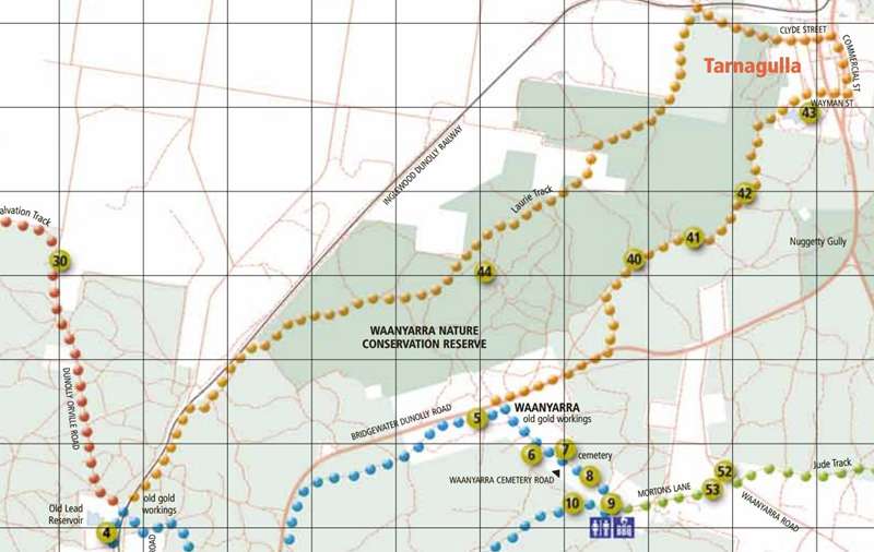
• reasonably easy forest ride
• includes nature conservation reserve
The Tarnagulla ride is an extension of the Waanyarra or Laanecoorie ride, or can be started after riding from Dunolly on the sealed Dunolly Tarngulla Road. Look out for the track sign indicating left at Weed Track as indicated on the cycle track map.. This ride is reasonably easy with good track surfaces and gentle undulations. Tarnagulla is a pretty town and well worth exploring, but carry food etc with you because there are few shops left here. The ride along Laurie Track takes you along side the Green Range and through the Waanyarra Conservation Reserve a wonderful area for wildflowers in spring. The track takes you to the Old Lead Reservoir where the sealed road takes you south, back to Dunolly
40 Intersection named Four Corners after a four trunked ironbark tree.
41 Site of the Secret Lead - an area worked by Chinese miners c.1850s, but eventually discovered by Europeans.
42 Water catchment channel for the Tarnagulla Reservoir.
43 Tarnagulla Reservoir and recreation reserve. Historic grandstand believed to be the oldest remaining wooden grandstand in Victoria.
44 Remains of miners cottage c.1890.
Laanecoorie
Ddistance: 31km as marked (44km return to Town Hall)
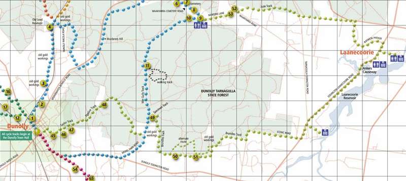
• variety of features
• includes some steep and rough sections
The Laanecoorie ride is for the more fit and experienced riders and mountain bikes are advised. The first rise is not far from Dunolly as you climb past the water supply above the town, then its up and down following the pipeline which brings water to the town from Laanecoorie. Along Brundells track there is quite a steep rocky pinch to a high point with a great view. Alternatives are to walk up this short climb of take the signed alternative route.
Once on the bitumen on the Eddington Laanecoorie road there is a great barbeque site signed and indicated on the map which overlooks the Loddon River. Back on the ride, you'll pass more barbeque facilities and toilets at Anchors Causeway and there's a kiosk at the Caravan Park just up the road at the Reservoir.
Raymon Parade is an unmade road but when you get back in the bush on Jude Track the going can get a bit rough again with short steep rises and rocky sections. From here the green signs take you to the Waanyarra Recreation area with toilets, shelter, barbeque and a camping area. From here you can follow the blue (Waanyarra signs) back to Dunolly or continue up to the Dunolly Tarnagulla Road to either continue on the Tarnagulla Track or ride back to Dunolly on the bitumen.
45 Channel established in 1879 to divert floodwaters from the town.
46 Site of town's gun powder magazine.
47 Dunolly Basin. Town water supply established 1947 with water now piped from Laanecoorie Reservoir.
48 Exposed water pipeline from Laanecoorie Reservoir.
49 Little Chinamans Gully. Diggings first worked in late 1856. Named by miners returning from the Chinamans Flat Diggings at Maryborough.
50 Steep rocky rise with a good view.
51 Banks Reef, 300m to right, worked in the 1880s. A very rich reef with horses used underground.
52 Site of Waanyarra State School. Operated from 1877 to 1942.
53 Mortons Hotel built in the 1860s. Also used as a shearing shed.
Betley
Distance: 19km return to Town Hall
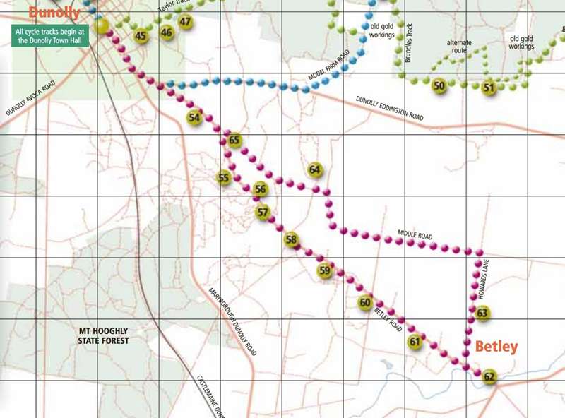
• reasonably easy ride through farmland
The Betley ride is reasonably easy and is through farmland rather than forest. The section from Dunolly to Betley is a quiet sealed road and then the the road is unmade along Howards Lane and Middle Road. This path takes you past what once were the thriving communities of Bromley and Burnt Creek plus a number of sites of commercial goldmining of the 1890s and 1900s.
54 Site of the Cairns Reef, one of the last reef mines worked around Dunolly.
55 Burnt Creek Cemetery established c.1854. Possibly 200 people buried. Three existing headstones.
56 Burnt Creek Dredge Hole. From 1904 to 1912, the area from the bridge to this point was dredged to bedrock and progressively reclaimed.
57 Anderson Street. The main street of Burnt Creek township. In 1861 there were 6000 people here.
58 Site of Bromley township.
59 The Hong Kong Lead to the west of the road. The deep lead Caledonia Mine-worked in 1870s.
60 To the west of the road (300m), the deep lead Burnt Creek Mine started in the 1880s.
61 West side of the road is the Sweet Nell Mine, worked in the 1890s and early 1900s.
62 Township of Betley, originally called Middle Bridge. This town survived because of deep lead mines and farming. Many fruit orchards were planted here until a big flood in 1936 washed most trees away.
63 On the east side of the road is the Burnt Creek No 1 Mine. Operated in the 1890s.
64 To the north, Wild Dog Hill was worked in 1856. Amongst peppercorn trees are remains of the old kerosene-tin house. There were two of them. A family of seven lived here in the 1930s.
65 The Bromley State School opened in 1864. First built with timber as the Burnt Creek School and then replaced with stone a few years later. Operational until 1972.
Location
85 Broadway, Dunolly 3472 View Map
Web Links
→ dunollycycle.com
→ Dunolly Cycle Tracks Map (PDF)


