Dunkeld Heritage Trail


The Dunkeld Heritage Trail is a self-guided walk through the historic centre of Dunkeld. The trail has 26 locations marked by steel interpretive panels which explore the town's buildings, businesses and stories from the early twentieth century.
In January 1944, fires destroyed approximately one-third of Dunkeld's houses and businesses. Many local residents were away serving during World War II, making the fire particularly devastating for the small community. The trail records the buildings that survived, those that were lost and the way the town developed after the disaster.
The route follows streets around central Dunkeld, including Parker Street, Sterling Street, Templeton Street, Wills Street, Martin Street and Skene Street. It also visits Victoria Park and the former railway precinct.
Allow approximately 60-90 minutes to follow the complete trail, depending on how long you spend reading the interpretive panels.
Dunkeld Heritage Trail Map
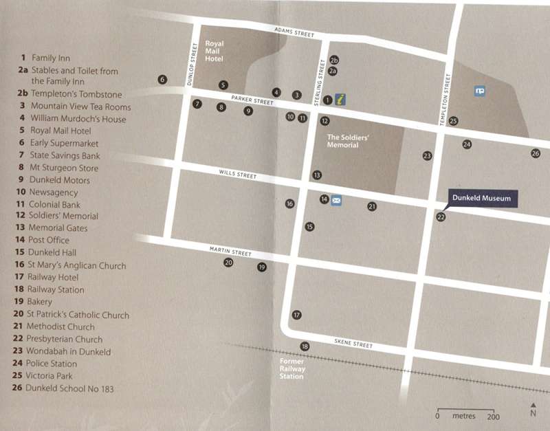
The numbered locations are:
1. Family Inn
2a. Stables and Toilet from the Family Inn
2b. Templeton's Tombstone
3. Mountain View Tea Rooms
4. William Murdoch's House
5. Royal Mail Hotel
6. Early Supermarket
7. State Savings Bank
8. Mt Sturgeons Store
9. Dunkeld Motors
10. Newsagency
11. Colonial Bank
12. Soldiers' Memorial
13. Memorial Gates
14. Post Office
15. Dunkeld Hall
16. St Mary's Anglican Church
17. Railway Hotel
18. Railway Station
19. Bakery
20. St Patrick's Catholic Church
21. Methodist Church
22. Presbyterian Church (Dunkeld Museum)
23. Wondabah in Dunkeld
24. Police Station
25. Victoria Park
26. Dunkeld School No. 183
Access for Dogs:
Dogs are permitted along the public streets and outdoor sections of the trail when kept on a leash. Dogs may not be permitted inside buildings or individual attractions.
Facilities:
Public toilets, picnic facilities, shops, cafes and visitor information are available in central Dunkeld.
Location
Sterling Street. Dunkeld 3294 View Map


