Dargon's Homestead Walk (Belgrave Heights)

Dargon's homestead is one of the oldest surviving heritage sites in the foothills of the Dandenongs, but one that is little known. This 6km heritage walk combines spectacular views, much birdlife and more.
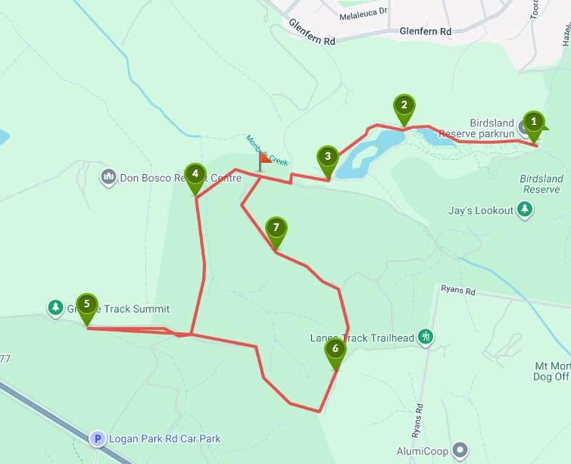
Dargon's Homestead Walk Map
Interactive map
Points of Interest
1. Birds Land
This well equipped picnic area is the starting point for this heritage walk. Birds land has BBQs, toilets and shelter, and is only a short distance from the main road in Upwey
2. Lake circuit
The flat and well maintained paths around the two lakes are the most popular local walk. There is much birdlife, and many wayside seats at which to stop, rest, and take in the view
3. Retaining wall
This flood mitigation basin was constructed in the early 1980s. The nearby gate is a meeting point for several tracks: Nixon Road to the north is steep
4. Dargon's homestead
Thomas Dargon 'selected' this land and built a homestead in 1845. He drowned attempting to cross Dandenong Creek in 1862. His widow re-married, to Robert Nixon, and is buried in FT Gully cemetery
5. Strettle's granite
Abraham Strettle purchased a property in this area in 1866 and called it 'Strettle's granite'. The view from the tors to the north and west is worth the steep climb from Dargon's track
6. Abrahams track
This section of track is sheltered on a warm day. The farm on the other side of the fence is modern, but evidence of earlier farms is just around the corner
7. Sunset track
Sunset track descends steeply to rejoin the main trail to return to our starting point at Birds Land. The dams beside the trail are evidence of earlier farms, and now home to numerous frogs.
Location
271 Mt Morton Road, Belgrave Heights 3160 View Map
Web Links
→ Dargon's Homestead (Walking Maps)


")