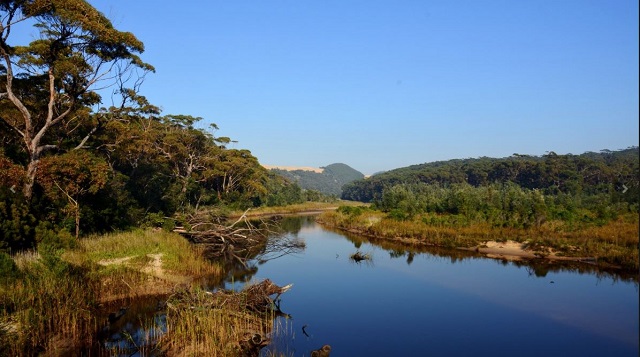
Wingan River - Croajingolong National Park


Named after the Aboriginal people of the area, Croajingolong National Park follows the far‐eastern coastline of Victoria for 100 kilometres and features eucalypt forest, rainforest and heathland. Croajingolong is a great spot for walking, remote coastal camping and all water activities.
Things to See and Do
Walking
Throughout the park there are some delightful walks that explore the many different environments in this area, with sandy beaches, colourful heathlands, vast dune fields, tall eucalypt forests and rainforests. Many are located near the park's main campgrounds.
Saros Track - 650m, 45 minutes return
Enjoy magnificent views of the coast as you follow the path to view the shipwreck of the SS Saros that ran ashore during heavy fog on its way to Sydney in 1937. The track departs from the grassy area 100m west of the Lightstation.
Dunes Walk - 4km, 2 hours return
Explore a unique landscape of soaring sand dunes towering above the Thurra River. The walk begins at the Thurra River Campground near campsite 14 and winds through coastal banksias and heathland before opening out into a network of sandy trails through the dunes. There are no walking track markers once on the dune fields due to the constantly shifting sands, so take careful note of your return route.
Point Hicks Lighthouse - 4.5km, 1.5 hours return
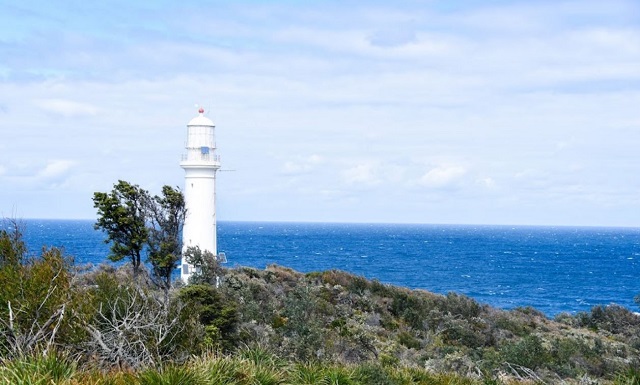
Experience pristine natural beauty and immerse yourself in history as you walk to the Lightstation. The walk commences at the Lightstation Reserve gate. Once at the Lightstation Car Park, a track to the left of the grassy area leads down to the monument and then up to the light tower. Access inside the Lightstation's stone walls is limited to visitors staying in the keepers' accommodation.
The Point Hicks Lighthouse was built in 1887-88, and was first lit in May 1890. In a break with tradition at the time, the tower was constructed of concrete. The two keepers quarters were built from timber. The kerosene lamp and clock mechanism were upgraded to electric operation with the connection of mains power in 1965. The light was more recently converted to solar power.
The lighthouse is believed to be haunted by the ghost of former Lightkeeper Christofferson. An unusual feature of the light tower is its cast iron spiral staircase, which has 162 steps cantilevered from the walls, rather than the traditional stone steps which are built around a central column.
Note: The closest vehicular access to the lighthouse is a car park three kilometres away. The rest of the journey is made on foot.
The lighthouse grounds are open all year round and tours and lighthouse accommodation is available.
Mt Everard - 6km, 3 hours return
Enjoy spectacular views of the surrounding forests and heathlands as well as Point Hicks and the dunes from a large sloping rock face on Mt Everard. The track commences from the car park on the Mt Everard Track. To access the track, turn off the Point Hicks Rd onto Cicada Trail (4WD only), 6km north of Thurra River Campground.
Genoa Peak - 1.5km, 1 hour return
North west of Mallacoota, Genoa Peak offers magnificent views of the Wilderness Coast, the Thurra Dunes and Mallacoota Inlet. To access Genoa Peak, a gravel road from the Princes Highway leads to a picnic area, where a walking track provides access to the summit.
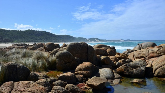
Clinton Rocks Walk - 8km, 4 hours return
This walk starts at Tamboon Inlet, which is only accessible by boat. Walk east along the beach to explore the giant granite boulders covered in brilliant orange lichen at Clinton Rocks. The walk boasts spectacular views of the coast, and on a clear day the Point Hicks Light Tower is visible. Alternatively, it is possible to drive down Clifton Rocks Track and walk 150m to the beach. Please take care, as rocks may be slippery and this area is subject to large, unexpected waves.
Wingan River Rapids - 5km, 2.5 hours return
Meander through fern gullies before winding down to the Wingan River where the track becomes narrow and in places is marked by rock cairns. Explore downstream into the rainforest or upstream into the cascading rapids. Access to the walking track is from the car park along Boundary Track. Please take care, as rocks may be slippery when wet or unstable and rapids are not suitable for white water rafting
Rame Head - 8km, 3 hours return
This walk will take you through coastal forest. The walking track begins at the western end of Fly Cove via the Beach Access Track at Wingan Inlet and meanders over the headland, terminating at Trig Point. Walkers are advised not to rock hop around Rame Head as access is dangerous due to high tides and sudden waves.
Lake Elusive - 6km, 2 hours return
Up to 21 metres deep, Lake Elusive is the deepest dune blocked coastal lake in Victoria. The walk commences at the small carpark on the West Wingan Road, 3km from the campground and meanders through tall eucalypt forest. At the end of the walk, visitors arrive at a white, sandy beach and have the opportunity to explore along the shoreline.
Heathland Walk - 2km, 30 minutes return
The Heathland Walk commences at the Shipwreck Creek Day Visitor Area and concludes at the communal cooking area. During spring and summer there is an amazing variety of wildflowers, some of which are classified as rare or threatened. Keep your eyes open for orchids.
Shipwreck Creek to Centre Track via Old Coast Road - 6.5km, 2 hours one way
The Old Coast Road Walking Track commences at the Shipwreck Creek Day Visitor Area, travels towards Mallacoota, and concludes at a carpark on Centre Track. This walk also provides spectacular views along the Wilderness Coast as it meanders through the heathland to a Bloodwood dominant forest further inland. There are great opportunities for birdwatching.
Wilderness Coast Walk - 100km, 7 days one way
The Wilderness Coast Walk extends 100km from the Eastern Shores of Sydenham Inlet in Croajingolong National Park, to Wonboyn in the Nadgee Nature Reserve, NSW.
The walk can be accessed from a number of locations along the coastline. Two‐wheel drive access is available at Bemm River, Thurra River, Wingan Inlet and Shipwreck Creek. Please check on road conditions prior to entering the park.
Parks Victoria and the NSW National Parks and Wildlife Service require walkers to book in order to manage numbers and minimise visitor impact on these remote areas.
Boating
There are launching ramps for boats at Karbeethong, Mallacoota, Gipsy Point, Tamboon Inlet and Bemm River, with an effluent waste disposal facility located at the Karbeethong public jetty on the Mallacoota Lakes. Small boats (maximum 20 horsepower) may be launched at Wingan Inlet.
The islands located in the Mallacoota and Tamboon Inlet's are utilised as nesting sites by coastal and wading birds. In order to provide safe and undisturbed nesting habitat, please do not land on the islands between October and February.
Canoeing
Some of Australia's best flat water canoeing can be found throughout the park on the many rivers, streams and estuaries. Sea kayaking is a challenging activity along the spectacular coastline.
Fishing
Fishing is permitted within the park (excluding Marine National Parks) and a number of different surf and estuary fish species may be caught. A Victorian Recreational Fishing Licence is required to fish in all Victorian waters.
Four‐wheel driving
Several tracks lead to remote locations or create alternative touring routes through the park and adjoining state forest. Check with Parks Victoria or DELWP for updated road conditions and seasonal closures before setting out. Road closures apply to all vehicles.
Camping
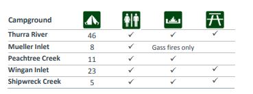
There are four main camping areas in Croajingolong National Park with an additional campground at Peachtree Creek Reserve.
Camping is only permitted in the designated camping areas and is not permitted around the Mallacoota Lakes. Toilets and barbecues are provided in all campgrounds and fees apply. Mueller Inlet has no barbecues and no fires are allowed, so visitors need to bring their own gas barbecues or burner. Motorised boats are also prohibited.
Advance bookings are required for Shipwreck Creek, Wingan Inlet, Thurra River, Mueller Inlet and Peachtree Creek campgrounds.
Lightstation accomodation cottages are available at both Point Hicks and Gabo Island Lightstation Reserves.
The nearby towns of Cann River and Mallacoota also offer campgrounds and motel accommodation.
Access for Dogs:
Dogs and cats are not permitted in the park.
Getting there
Croajingolong National Park in Far East Gippsland is located approximately 450km east of Melbourne and 500km south of Sydney.
The park is accessed from multiple points along the Princes Highway between Cann River and the New South Wales border. Roads to Wingan Inlet, Mueller Inlet, Thurra River and Shipwreck Creek campgrounds are unsealed and not recommended for caravans. Access is weather dependent.
Note: Photos from Parks Victoria
Location
W Wingan Road, Wingan River 3891 View Map
Web Links
→ Croajingolong National Park (Parks Victoria)
→ Croajingolong National Park - Visitor Guide (PDF)
→ Croajingolong National Park - Walk the Wilderness Coast (PDF)
→ Croajingolong National Park - Mallacoota Inlet (PDF)
→ Croajingolong National Park - Walks (PDF)
→ Croajingolong National Park - Walk Around Stringybark Creek (PDF)


")