Creswick - Buried Rivers of Gold Self-Guided Tour


The Buried Rivers of Gold self guided tour is approximately 31 km long and will take about 90 minutes to complete by car. It covers the world's richest alluvial goldfield encompassing Creswick, Allendale, Broomfield, Kingston and Smeaton.
Total Gold Won: 2.8 million ounces (51 tonnes)
Total Value: $70,000,000,000 (70 billion dollars @ $2,500 per ounce)
Athough the early gold rushes of the 1850s in the creeks and gullies surrounding Creswick brought prospectors, mining parties, families and businesses to the riches of the area, the later discovery of a new 'deep lead' deposit of gold, buried in ancient rivers under the basalt lands to the north east, secured the Creswick district a place in history as the world's richest deep alluvial goldfield.
This intense era of mining activity not only produced 51 tonnes of gold, it also fast-tracked Victoria's engineering and manufacturing capabilities into the Twentieth Century, contributed to the rise of democratic workers' movements in Australia and, finally, left its legacy on the surrounding landscape, a landscape for you to now explore.
You are encouraged to immerse yourself in this self-guided tour and take a step back in time - to imagine, to learn, and ultimately to keep the history of these buried rivers of gold alive.
A very nice brochure can be obtained from the Creswick Visitor Information Centre.
The five informative signs are on the roadside, so please park well off the road.
Please note: Many of the shafts are unfenced and are on private property. Only the New Australasian No. 2 mine site has public access.
(Southern part of the Buried Rivers of Gold Self-Guided Tour)

STOP 1. THE FATAL DRIVE - NEW AUSTRALASIAN NO.2
Your tour begins at the site of Australia's worst gold mining disaster. The 22 men who lost their lives in the flooding of this mine serves as a solemn reminder of the dangers deep lead miners faced everyday. There are several memorials and interpretive signs at this site.
"LIKE THEIR OWN SHADOW, THE EVER-PRESENT THREAT OF AN ACCIDENT WAS WITH A MINER"
This mine site serves as a memorial to the 27 miners who were trapped when the New Australasian No. 2 mine flooded in 1882. It also commemorates the heroic efforts undertaken to rescue the miners.
A miscalculation of distance between the abandoned and flooded Australasian No. 1 mine and a lack of escape routes above the main drive in the new mine spelt disaster for 22 of the entombed miners.
END OF AN ERA
By the 1890s, gold production on the field began to decline. As the earlier mines closed, their richest gutters having been 'worked out', water flowing down into the mines to the north became a critical problem that caused excessive delays in production and therefore profitability.
Investors became weary and eventually the mines, mining families and their townships closed and anything of value was stripped and removed.
On the surface the pump was pushed to its liMit removing -190,000 litres per hour and a dive team from HMVS Cerherus at Williamstown was dispatched.
Throughout the three-day rescue effort some 3,000 townsfolk became immersed in a tragedy that the miners had always feared would happen.
The inquest examining the disaster resulted in increased safety controls. Controversially however, in 1884 the £20,500 donated for the widows became the The Mining Accident Relief Fund Act with much of the fund being distributed elsewhere.
By the early 1900s the height of the boom was well over. The permanent agricultural towns of Kingston and Smeaton shrank back to their original size, leaving only the mullock heaps, slime dams and the occasional brick ruin we see today to remind us of this spectacular era of mining.
From Creswick-Clunes Road, head north on Creswick Lawrence Reel to follow the mullock dumps from mines that worked the Australasia Lead including West Berry Consols which ceased operations in 1911.
STOP 2. THE DARK LABYRINTH - MADAME BERRY WEST
The stop at Madame Berry West No. 1 will give you an insight into the labour intensive underground working conditions of a deep lead mine. Carbonic gas, heat and the tense fear of water bursting through also combined to make these mines extremely dangerous and difficult to work in.
(Northern part of the Buried Rivers of Gold Self-Guided Tour)
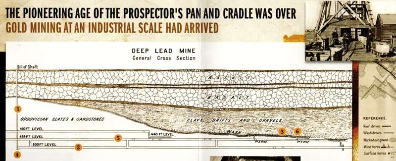
Mining the Deep Leads required first the sinking of a shaft (1) through the basalt into the solid bedrock to a level below the ancient river beds 'wash gutter'.
From near the bottom of the shaft, a main reef drive (2) was excavated out and under the wash gutter (3). Drives were excavated so that all water would flow back to the sump (4) in the shaft where it was lifted to the surface by pumps. This also assisted hauling the ore trucks (5) back to the shaft as it was a 'downhill' run. The clay, sand and slate that was removed from the drives remains on the surface today as 'mullock heaps'.
As the wash gutter 'leads' of the ancient rivers were well below the water table, they were saturated with pressurised water, which had to be drained before mining could commence. To do this intermittent bore holes were drilled up into the lead from the drive below. These bores allowed miners to establish the position of the lead, gain indications of gold in the gutter and to 'bleed-off' the water at a controlled rate so the capacity of the pumps in the shaft was not exceeded.
IN SOME MINES PUMPING CONTINUED FOR YEARS BEFORE THE WASH GUTTER WAS DRAINED ENOUGH TO BE ENTERED
'Rises' leading up and into the gutters (6) were excavated to access the wash and as the lead was followed, a network of trucking and intermediate drives was created back to the shaft.
In order to extract the gold in the wash gutter, timber props, caps and laths were closely interlocked to form a 1.2m high enclosure. This dark timbered tunnel was the only protection the miners had from being suddenly engulfed by water, drift or falling rocks.
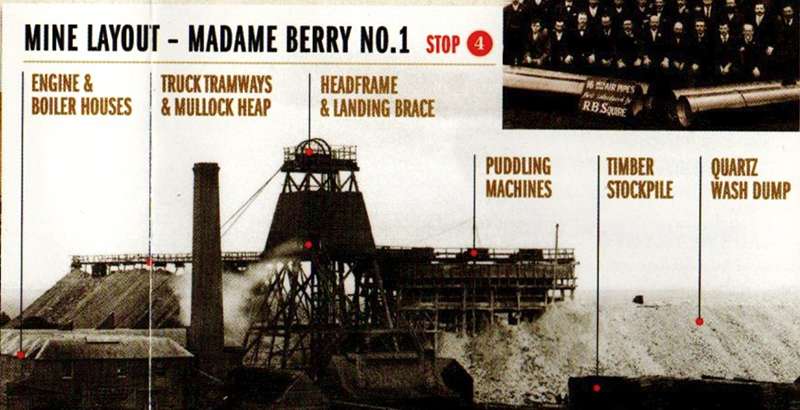
The wash was precariously removed in sections at a time and the trucks of wash were hauled back to the shaft by pit ponies who lived underground. The trucks were lifted above ground to the Landing Brace and tipped into large iron tanks called puddlers where water and iron rakes broke off the clay and dirt to free the gold. The large pieces of cleaned quartz were removed and trucked along the tramway to the wash dump and the clayey water was piped out to settle in the timber walled slime dam. This left only the finer gravels which were run over sloping cloth tables, catching the gold, which was then taken to the gold room.
Continue north and detour into Beaconsfield Road for a closer look at the Madame Berry No.3 slime dam. Slime dams were timber walled enclosures where clayey water from the mine settled, trapping the clay.
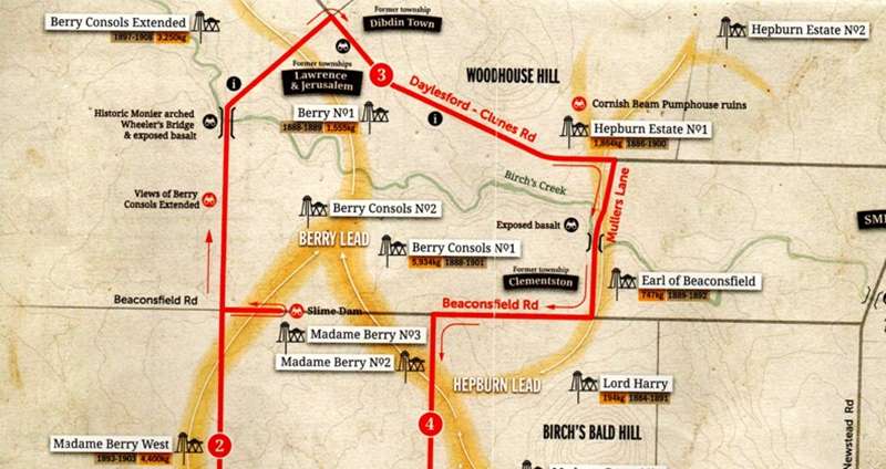
STOP 3. INDUSTRIAL STRENGTH - BERRY NO. 1
Confronted with large flows of water, mining companies erected some of the most extensive pumping systems in Australia. Berry No. l's Cornish Beam Pump was manufactured in Ballarat and was capable of lifting 270,000 litres of water per hour from the 200m deep shaft. Here you will learn about and see the spectacular remains of the three-storey brick and bluestone pumphouse.
The second Cornish Beam Pumphouse on the goldfield can be seen from the road at Hepburn Estate No.1 mine site. Drive slowly down Mullers Lane to get a good view of the basalt that has been exposed by Birch's Creek.
The complexities of water, drift and the working depths of these unique mines demanded many local engineering and technological innovations. At the forefront of Victoria's industrialisation, much of the equipment was engineered and manufactured in Ballarat, including two Cornish Beam Pumps; their 10 ton engines being the largest built in the Southern Hemisphere.
STOP 4. THE JEWELLERY BOXES - MADAME BERRY
The Madame Berry mines, positioned on the famous Berry Lead, are unquestionably some of the most successful mines in the history of Victoria. The company's surface operations were also some of the largest and most technologically advanced industrial sites in Australia in the 1880s.
Turning left into West Berry Road you will pass Loughlin No. 1, named after Martin Loughlin; a man who not only profited from the royalties of owning the land, but the dividends from many of the mines upon it.
STOP 5. THE TRANSIENT MINING TOWNS
From 1872 until the closure of the South Berry mine in 1914, 10 townships were created on the goldfield and of these, Allendale became one of the most important townships in Australia. As the mines closed, the smaller towns disappeared, but Allendale remains - a survivor with a golden past.
Like Lewers, Bailey and Loughlin who were making their fortunes from royalties, Thomas Dibdin saw his golden opportunity in the inevitable demand for housing and the building of private towns.
The first purpose-built mining town was Allendale where in the early 1880s Dibdin sold hundreds of cottages all of the same design: unpainted weatherboard with four rooms all lined inside with hessian and paper, an iron roof with one chimney for either an open fire or a stove and a 'dunny' shared between two houses.
As mining operations moved, new townships followed to provide the houses, halls, schools, churches, hotels and the array of local businesses required by the company miner and his family. Of the 10 towns created to service the goldfield, only Allendale and Broomfield remain. The 'lost townships' of Ristori Town, Clementston, Wallace Town, Dibdin Town, Smokeytown, Jerusalem, Lawrence and Hollinwood were either shifted on drays, dismantled or abandoned.
PROSPERITY AND SPIRIT
At their peak production, the large mines, like Madame Berry West, employed up to 350 boys and men who worked eight hour shifts, six days a week.
Townships were formed to service the goldfield and businesses hurried to supply the endless orders of building materials, iron fittings, engines, ropes, cables, boilers, pipes and pumps for the expanding mines
- and blacksmiths, butchers, wagoners, ministers and bootmakers gravitated to the booming new mining towns.
In these prosperous days it was not uncommon to see a thousand people crowded into the Ballarat Stock Exchange when gold yields were released; "The charged atmosphere being similar to that of a Melbourne Cup or a football final". J Graham
From Allendale turn left into Stag Road then turn right into Grays Road , and slowly take in the ! landscape on either side. You are now surrounded by the early mines as they followed the deep leads down from Spring Hill. Turn right into Alcorns Road and if safe, stop at the crest to take in the panorama of the entire goldfield below.
STOP 6. THE GOLDEN GATES
The mullock heaps in. front of you at this stop are the remains of three of the earliest mines that worked the exceedingly rich Lewers Western Lead. Sustained profitablity in these new Spring Hill mines proved to investors that great wealth lay ahead in what was only the beginning of the richest deep alluvial goldfield in the world.
THE GOLDEN GATES - DISCOVERY, EXPLORATION AND ENTERPRISE STOP
The discovery in 1872 of gold below Broomfield Gully began the much-needed revival of mining in Creswick which was in stow decline after the gold rushes of the mid 1850s.
Government geologists had regarded the basaltic plains of the area as nonauriferous, so Brawn, Carter and Graham's discovery of a new gold source aroused great speculation.
By late 1872, their 'Golden Gate' mine had produced nearly 80kg of gold and this success encouraged a local bank manager, Mr Lewers, to open his lands on the north side of Spring Hill to mining for a royalty of 10% paid for the value of gold recovered.
Local mining syndicates now rushed to secure their right to mine on the freehold farmlands which led to three separate leads between Broomfield and Kingston being discovered and worked to great success.
By late 1870s no fewer than 20 mines had produced nearly five tonnes of gold from the Lewers, Lewers Western and Reserve leads and some mines had delivered incredible returns on investment from the gradually descending river beds.
IT WAS NOW EVIDENT THAT THESE ANCIENT RIVERS WERE GRADUALLY GETTING DEEPER AND RICHER AS THEY HEADED NORTH DOWNSTREAM
The early successes at Spring Hill didn't go unnoticed. In 1875 William Bailey, Martin Loughlin and associates bought up all the freehold land over the projected goldfield and created the 'Seven Hills Estate' to profit from royalties and influence gold production.
The early mines were formed by small private syndicates which operated at relatively shallow depths, but as the leads weaved downstream, the working depths, volume of pressurised water and the presence of deadly gasses were becoming hazardous.
Deeper mining also required greater capital and companies' owners and shareholders banded together to make their fortunes while the company's miners united with W.G. Spence and the Amalgamated Miners Association for better working conditions and injury payments.
The gold won by miners now determined the share price, the profits paid dividends and land owners received their royalties.
Gold mining at an industrial scale had arrived and with it both fortune and tragedy were to be encountered.
Continue along Alcorns Road into Frenchmans Road to return to Creswick. Alternatively, turn right onto Smokey-town Road, head north taking the first left down into Broomfield to visit the Deep Lead Monument.
BRIEF GEOLOGICAL HISTORY
During the Ordovician period (-450 million years ago) this area of Victoria was under a shallow sea and over time, layers of sand and mud hardened to form sedimentary rocks. Clay and mud formed mudstone and shale and sand formed sandstone. Pressure from geological forces caused these layers of rock to fold and break creating cracks called joints or faults.
About 400 million years ago, molten rock was pushed up (intruded) into these faults and without breaking the earth's surface heated the sedimentary rocks to form metamorphic rocks. Mudstone and shale became slate and sandstone liquified to become quartzite. The igneous molten rock never reached the surface and crystallised into granodiorite (granite).
Mineral-rich liquids later permeated into the Ordovician rocks under immense heat and pressure. This gold-bearing fluid was pushed into the cracks or faults where it crystalised and formed quartz veins (reefs) with gold.
About 200 million years ago, the Ordovician plateau, with its veins of gold-filled quartz, was crushed and carved by glaciers as they moved northward from the elevated surrounds of Ballarat.
ANCIENT RIVERS BURIED UNDER LAVA
After the glacial periods, the crushed surface was subjected to rainfalls much stronger than those of today. Over time, the soft slates and sandstones were eroded down, granites exposed and the quartz reefs gradually weathered away releasing the gold within.
This alluvial gold, being heavier than rock, sank deep into the valleys and was washed into the creeks and rivers. As the river banks continued to erode and shift, the 'wash' became covered by layers of gravels (coarse drift), sands (fine drift), clays and layers of vegetation and fallen trees.
Several million years ago, molten rock (lava) in the form of basalt, made its way to the surface -through vents in the earth. The pouring of lava from the surrounding volcanoes slowly covered the ancient rivers and valleys. In many places separate lava flows from separate volcanoes were layered one on top of the other to become over 150m thick.
The basaltic lava cooled entombing the ancient rivers and valleys, creating the undulating plains we see today. Here, well beneath the water table of the country, these 'buried rivers of gold', or as the miners called them 'deep leads', remained undiscovered until 1872.


")