Corangamite Lake Road Playground, Cororooke


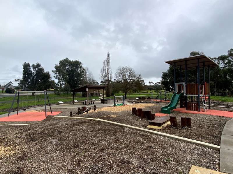
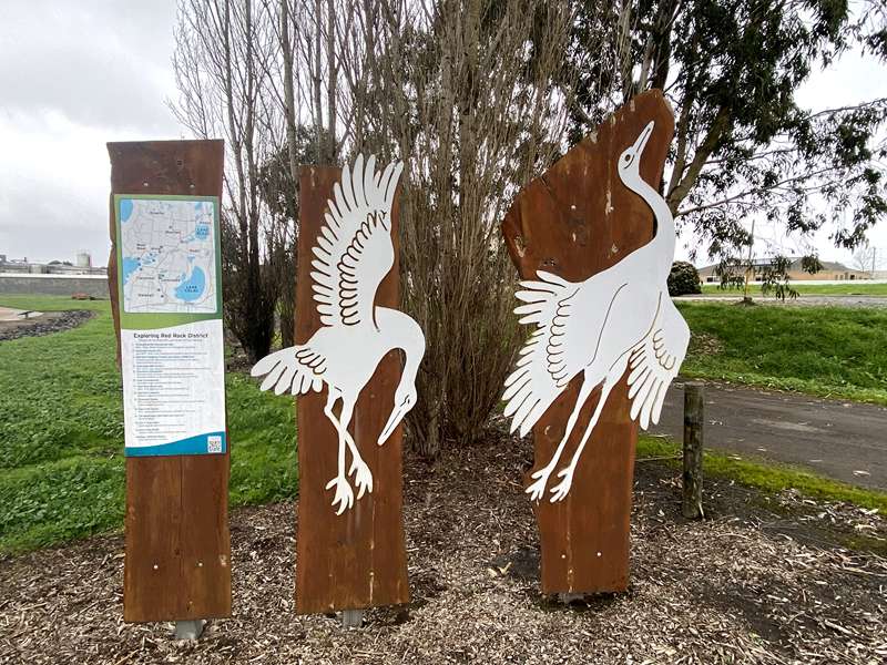
A really interesting playground with a Diprotodon and dancing Brolgas as you enter. A concrete path circles the playground and has interesting historical panels detailing the area back to 100,000 years ago.
The main play structure has a wave slide, climbing wall, rope net ladder, rigid frame ladder and shopfront. On sloping sides are a small dual wave side, single wave slide and rope nets. At the bottom level is a big sandpit with digger, standard swings, birds nest swing, rope climbing frame and lots of log and rock steppers.
Shelter with table, unshaded table and seats, BBQs, water tap, toilets, free public tennis courts and small grassy area.
Historical Information Boards
100,000 YEARS AGO
The Diprotodon
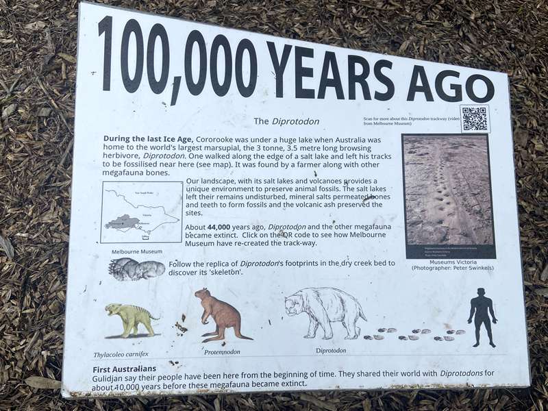
During the last Ice Age, Cororooke was under a huge lake when Australia was home to the world's largest marsupial, the 3 tonne, 3.5 metre long browsing herbivore, Diprotodon. One walked along the edge of a salt lake and left his tracks to be fossilised near here (see map). It was found by a farmer along with other megafauna bones.
Our landscape, with its salt lakes and volcanoes provides a unique environment to preserve animal fossils. The salt lakes left their remains undisturbed, mineral salts permeated bones and teeth to form fossils and the volcanic ash preserved the sites.
About 44,000 years ago, Diprotodon and the other megafauna became extinct.
Follow the replica of Diprotodon's footprints in the dry creek bed to discover its 'skeleton'.
First Australians
Gulidjan say their people have been here from the beginning of time. They shared their world with Diprotodons for about 10,000 years before these megafauna became extinct.
80,000 YEARS AGO
Volcanic Eruptions
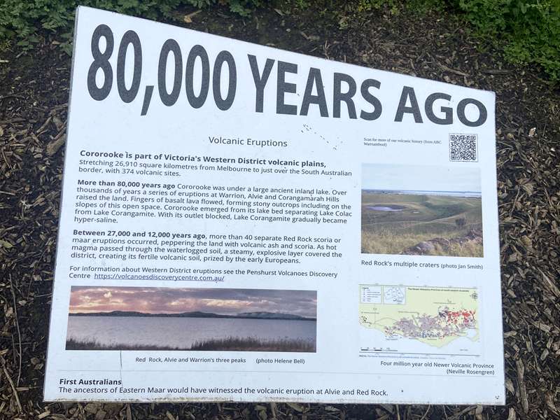
Cororooke is part of Victoria's Western District volcanic plains. Stretching 26,910 square kilometres from Melbourne to just over the South Australian border, with 374 volcanic sites.
More than 80,000 years ago Cororooke was under a large ancient inland lake. Over thousands of years a series of eruptions at Warrion, Alvie and Corangamarah Hills raised the land. Fingers of basalt lava flowed, forming stony outcrops including on the slopes of this open space. Cororooke emerged from its lake bed separating Lake Colac from Lake Corangamite. With its outlet blocked, Lake Corangamite gradually became hyper-saline.
Between 27,000 and 12,000 years ago, more than 40 separate Red Rock scoria or maar eruptions occurred, peppering the land with volcanic ash and scoria. As hot magma passed through the waterlogged soil, a steamy, explosive layer covered the district, creating its fertile volcanic soil, prized by the early Europeans.
First Australians
The ancestors of Eastern Maar would have witnessed the volcanic eruption at Alvie and Red Rock.
60,000 YEARS AGO
These animals were plentiful in this area. Find their tracks along the path.
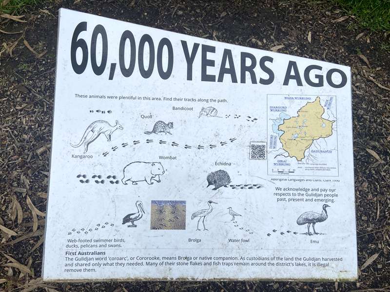
First Australians
The Gulidjan word 'coroarc', or Cororooke, means Brolga or native companion. As custodians of the land the Gulidjan harvested and shared only what they needed. Many of their stone flakes and fish traps remain around the district's lakes, it is illegal remove them.
40,000 YEARS AGO
Native Vegetation
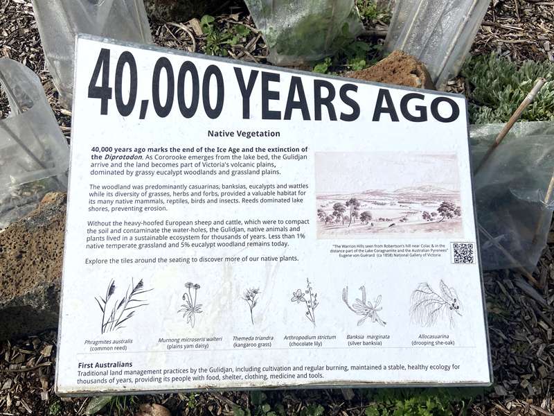
40,000 years ago marks the end of the Ice Age and the extinction of the Diprotodon. As Cororooke emerges from the lake bed, the Gulidjan arrive and the land becomes part of Victoria's volcanic plains, dominated by grassy eucalypt woodlands and grassland plains.
The woodland was predominantly casuarinas, banksias, eucalypts and wattles while its diversity of grasses, herbs and forbs, provided a valuable habitat for its many native mammals, reptiles, birds and insects. Reeds dominated lake shores, preventing erosion.
Without the heavy-hoofed European sheep and cattle, which were to compact the soil and contaminate the water-holes, the Gulidjan, native animals and plants lived in a sustainable ecosystem for thousands of years. Less than 1% native temperate grassland and 5% eucalypt woodland remains today.
Explore the tiles around the seating to discover more of our native plants.
First Australians
Traditional land management practices by the Gulidjan, including cultivation and regular burning, maintained a stable, healthy ecology for thousands of years, providing its people with food, shelter, clothing, medicine and tools.
1837
European arrival
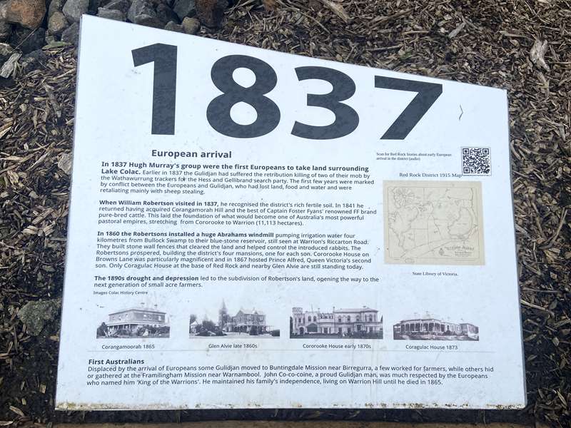
In 1837 Hugh Murray's group were the first Europeans to take land surrounding Lake Colac. Earlier in 1837 the Gulidjan had suffered the retribution killing of two of their mob by the Wathawurrung trackers for the Hess and Gellibrand search party. The first few years were marked by conflict between the Europeans and Gulidjan, who had lost land, food and water and were retaliating mainly with sheep stealing.
When William Robertson visited in 1837, he recognised the district's rich fertile soil. In 1841 he returned having acquired Corangamorah Hill and the best of Captain Foster Fyans' renowned FF brand pure-bred cattle. This laid the foundation of what would become one of Australia's most powerful pastoral empires, stretching from Cororooke to Warrion (11,113 hectares).
In 1860 the Robertsons installed a huge Abrahams windmill pumping irrigation water four kilometres from Bullock Swamp to their blue-stone reservoir, still seen at Warrion's Riccarton Road. They built stone wall fences that cleared the land and helped control the introduced rabbits. The Robertsons prospered, building the district's four mansions, one for each son. Cororooke House on Browns Lane was particularly magnificent and in 1867 hosted Prince Alfred, Queen Victoria's second son. Only Coragulac House at the base of Red Rock and nearby Glen Alvie are still standing today.
The 1890s drought and depression led to the subdivision of Robertson's land, opening the way to the next generation of small acre farmers.
First Australians
Displaced by the arrival of Europeans some Gulidjan moved to Buntingdale Mission near Birregurra, a few worked for farmers, while others hid or gathered at the Framlingham Mission near Warrnambool. John Co-co-coine, a proud Gulidjan man, was much respected by the Europeans who named him 'King of the Warrions'. He maintained his family's independence, living on Warrion Hill until he died in 1865.
1900
Dairy
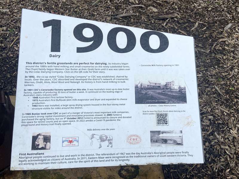
This district's fertile grasslands are perfect for dairying. Its industry began around the 1880s with hand milking and small creameries on the newly subdivided farms. The Chant family began Western Star Butter at their Ondit farm until it was was taken over by the Colac Dairying Company.
In 1892, the co-op styled “Colac Dairying Company” or CDC was established, chaired by locals. Over the years, CDC absorbed and developed the district's network of creameries: Warrion, Ondit, Alvie, Wool Wool and Nalangil. Its history is from hand milking to bulk tankers.
In 1901 CDC's Cororooke factory opened on this site. It was Australia's most up-to-date butter factory, capable of producing 30 tons of butter a week. It continued on the leading edge of Australia's dairy industry with:
- 1948 Australia's first lactose factory,
- 1972 Australia's first Buflovak skim milk evaporator and dryer and expanded its cheese production.
- 1983 Nero was installed, a large spray-drying system housed in the four-storey metal structure visible for miles around the district.
First Australians
Aboriginal people continued to live and work in the district. The referendum of 1967 was the day Australia's Aboriginal people were finally legally acknowledged as citizens of Australia. In 2011, Eastern Maar were recognised as the traditional owners of south western Victoria. They are working to maintain their culture, care for the spirit of this land and for its longevity.
1950
Onions Potatoes & Peas
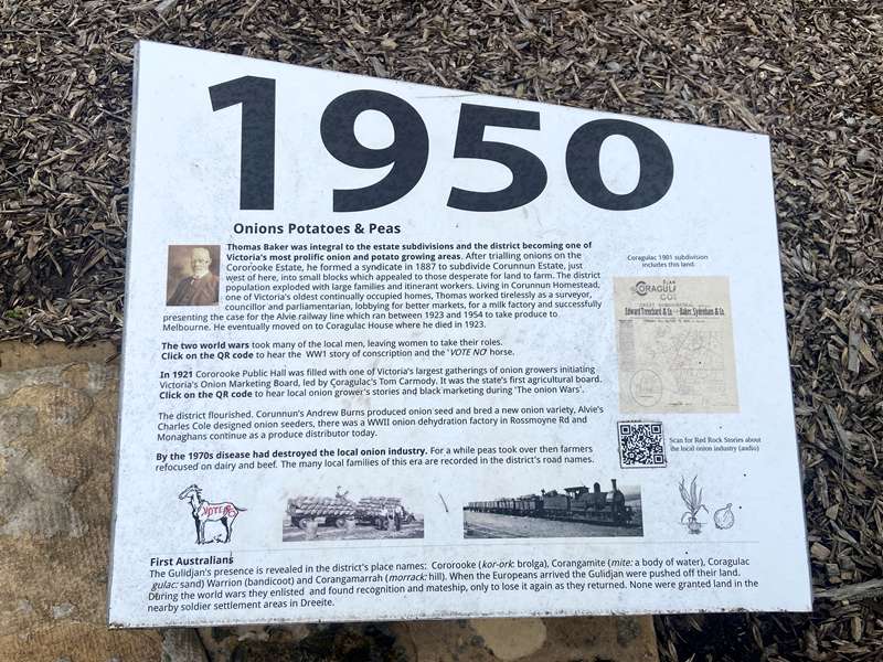
Thomas Baker was integral to the estate subdivisions and the district becoming one of Victoria's most prolific onion and potato growing areas. After trialling onions on the Cororooke Estate, he formed a syndicate in 1887 to subdivide Corunnun Estate, just west of here, into small blocks which appealed to those desperate for land to farm. The district population exploded with large families and itinerant workers. Living in Corunnun Homestead, one of Victoria's oldest continually occupied homes, Thomas worked tirelessly as a surveyor, councillor and parliamentarian, lobbying for better markets, for a milk factory and successfully presenting the case for the Alvie railway line which ran between 1923 and 1954 to take produce to Melbourne. He eventually moved on to Coragulac House where he died in 1923.
The two world wars took many of the local men, leaving women to take their roles.
In 1921 Cororooke Public Hall was filled with one of Victoria's largest gatherings of onion growers initiating Victoria's Onion Marketing Board, led by Coragulac's Tom Carmody. It was the state's first agricultural board. Click on the QR code to hear local onion grower's stories and black marketing during 'The onion Wars'.
The district flourished. Corunnun's Andrew Burns produced onion seed and bred a new onion variety, Alvie's Charles Cole designed onion seeders, there was a WWII onion dehydration factory in Rossmoyne Rd and Monaghans continue as a produce distributor today.
By the 1970s disease had destroyed the local onion industry. For a while peas took over then farmers refocused on dairy and beef. The many local families of this era are recorded in the district's road names.
First Australians
The Gulidjan's presence is revealed in the district's place names: Cororooke (kor-ork: brolga), Corangamite (mite: a body of water), Coragulac (gulac: sand) Warrion (bandicoot) and Corangamarrah (morrack: hill). When the Europeans arrived the Gulidjan were pushed off their land. During the world wars they enlisted and found recognition and mateship, only to lose it again as they returned. None were granted land in the nearby soldier settlement areas in Dreeite.
2023
Cororooke's 100,000 years of history
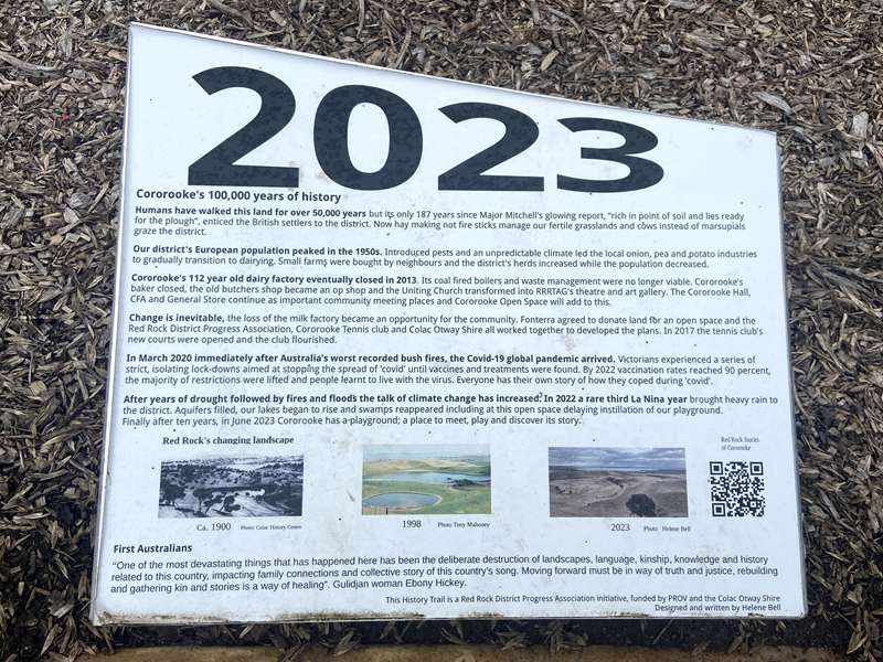
Humans have walked this land for over 50,000 years but its only 187 years since Major Mitchell's glowing report, “rich in point of soil and lies ready for the plough”, enticed the British settlers to the district. Now hay making not fire sticks manage our fertile grasslands and cows instead of marsupials graze the district.
Our district's European population peaked in the 1950s. Introduced pests and an unpredictable climate led the local onion, pea and potato industries to gradually transition to dairying. Small farms were bought by neighbours and the district's herds increased while the population decreased.
Cororooke's 112 year old dairy factory eventually closed in 2013. Its coal fired boilers and waste management were no longer viable. Cororooke's baker closed, the old butchers shop became an op shop and the Uniting Church transformed into RRRTAG's theatre and art gallery. The Cororooke Hall, CFA and General Store continue as important community meeting places and Cororooke Open Space will add to this.
Change is inevitable, the loss of the milk factory became an opportunity for the community. Fonterra agreed to donate land for an open space and the Red Rock District Progress Association, Cororooke Tennis club and Colac Otway Shire all worked together to developed the plans. In 2017 the tennis club's new courts were opened and the club flourished.
In March 2020 immediately after Australia's worst recorded bush fires, the Covid-19 global pandemic arrived. Victorians experienced a series of strict, isolating lock-downs aimed at stopping the spread of 'covid' until vaccines and treatments were found. By 2022 vaccination rates reached 90 percent, the majority of restrictions were lifted and people learnt to live with the virus. Everyone has their own story of how they coped during 'covid'.
After years of drought followed by fires and floods the talk of climate change has increased. In 2022 a rare third La Nina year brought heavy rain to the district. Aquifers filled, our lakes began to rise and swamps reappeared including at this open space delaying instillation of our playground. Finally after ten years, in June 2023 Cororooke has a playground; a place to meet, play and discover its story.
First Australians
“One of the most devastating things that has happened here has been the deliberate destruction of landscapes, language, kinship, knowledge and history related to this country, impacting family connections and collective story of this country's song. Moving forward must be in way of truth and justice, rebuilding and gathering kin and stories is a way of healing”. Gulidjan woman Ebony Hickey.
Photos:
Location
558 Corangamite Lake Road, Cororooke 3254 View Map


