Coleraine Walking Trail


The Coleraine Walking Trail explores the history, community life and natural environment of Coleraine through a series of illustrated storyboards located along Whyte Street, Bryan Creek and nearby parts of the town.
Each storyboard records a particular place, event or community memory. Visitors can also open the corresponding page on the Coleraine community website to hear an audio recording of the story.
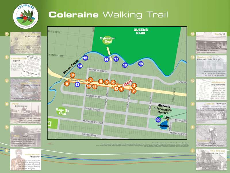
The first 12 storyboards are concentrated around Whyte Street and the town centre. Eight additional storyboards extend along Bryan Creek, towards Silvester Oval and around the Historic Information Centre, weir and lagoon.
The storyboards are not arranged chronologically and the trail can be started at any location.
Coleraine Walking Trail Map
Distance: No total distance has been published; the walking trail along Bryan Creek is described as approximately 2 km
Time: Allow 1-2 hours, depending on the number of storyboards visited
Route: Central township route with an extension along Bryan Creek
Start: The official map marks a starting point on Whyte Street near Henty Street, but the trail can be started at any storyboard
Terrain: Town streets, footpaths, parkland and creek-side tracks
Accessibility: No official accessibility grade has been published
Important Route Information:
The original storyboards are shown in orange on the official map. The later storyboards, mostly located along the Bryan Creek track, are shown in blue.
The mapped route extends from central Whyte Street to Bryan Creek, Silvester Oval, Queens Park and the Historic Information Centre area.
Walking Trail Storyboards:
1. The Peter Francis Points Arboretum
The first storyboard introduces the Peter Francis Points Arboretum and its nationally significant collection of eucalypts.
The arboretum was established within a former quarry after Peter Francis began collecting and growing eucalyptus species from throughout Australia.
2. Community Spirit
This storyboard explains how the Coleraine community responded when the town was at risk of losing its remaining banking service.
Community meetings led to the formation of a steering committee that worked with Bendigo Bank. The community bank opened in the former State Bank premises in April 2003.
3. Striped Legless Lizard
The Striped Legless Lizard is an endangered reptile found around the Coleraine district. Although it is often mistaken for a snake, it can be identified by its long, slender body and pronounced stripes.
The lizard shelters in grass tussocks, beneath rocks and within cracks in the ground.
4. The Polio Epidemic
This storyboard recalls the effects of the 1938 polio epidemic on Coleraine families.
Children were placed in quarantine, and local resident Janet Stanton remembered being concealed beneath a blanket in the back of the family car during a trip into town.
5. The 1946 Flood
The storyboard records a resident's memories of the destructive 1946 flood.
People were warned to leave their homes during the night, but floodwater had already entered some buildings. Water marks remained visible inside affected houses for many years.
6. Indigenous History
This storyboard contains an account provided by Indigenous Elder John Lovett concerning violent conflict between Aboriginal people and European settlers in the district.
It includes the history of the poisoning of Aboriginal people at Konongwootong and the later exposure of burial remains during the 1946 floods.
7. Circus Comes to Town
Travelling circuses arrived in Coleraine by train during the 1970s.
Local children hurried to the oval, where they could sometimes earn money feeding the horses. Circus animals were watered at Bryan Creek, including elephants that wallowed in the water.
8. The Swagmen
During the Depression of the 1930s, swagmen camped beneath the bridge near Bryan Creek.
Some travelled with rolled blankets and old bicycles, kept a billy boiling at their camps and collected stale bread from the local bakery.
9. Indian Hawkers
This storyboard recalls an Indian hawker who camped beside the creek during the 1930s.
His horse-drawn cart carried a wide selection of merchandise and operated as a travelling shop. He cooked over a campfire and shared food and stories with local children.
10. Coleraine's Big Stores
The building later occupied by the chocolate factory was once Wishart's Big Stores.
The large business sold everything from farm machinery and clothing to boiled lollies. Payments were transported from the sales counter to the office in canisters travelling along an overhead wire system.
11. Blacksmith Shop
This storyboard explains how Coleraine's historic blacksmith shop was saved from demolition.
A local consortium was formed to purchase the property after plans were made to demolish the building for new commercial premises.
12. Toyland
Trangmar's shop became a special destination for local children during the weeks before Christmas.
The shop was filled with toys and was remembered as being like a fairyland to children growing up in Coleraine during the 1930s.
13. Helena Rubinstein
Cosmetics entrepreneur Helena Rubinstein arrived in Australia in 1897 and initially stayed with relatives in Coleraine.
During her time in the town, she developed the idea of selling face cream imported from Poland. She later moved to Melbourne and established the business that brought her international success.
14. Avenue of Honour
Coleraine's original Avenue of Honour was planted with cypress trees in 1919 to commemorate local people who died during the First World War.
The avenue was burnt during the Black Saturday fires of 2009. It was replanted with kurrajong trees on the eve of Anzac Day in 2010 and now commemorates Australians lost in all theatres of war.
15. The Bridge
Several different bridges have crossed Bryan Creek.
An early timber swing bridge swayed noticeably when crowds crossed it on their way to and from sporting matches at Queens Park and Silvester Oval. The present single-lane vehicle bridge is located slightly east of the former swing bridge site.
16. Football
Coleraine Football Club was founded in 1882 and became one of the 12 original clubs in the Western Border Football League during 1964.
The club joined the South West District Football League in 1995 and is known as the Maroons.
17. Anyone for Cricket?
The history of the Coleraine Cricket Club dates to 1852, when the team was known as the Coleraine Invincibles.
The storyboard also explains the development of Silvester Oval during the 1920s as a cricket and football ground through an employment scheme for returned soldiers.
18. Bryan Creek
Bryan Creek was originally known as Koroite Creek and was later renamed after early pastoral settler John Bryan.
The creek was once an important recreational meeting place where local children swam, played games, used a flying fox and swung into the water from a rope tied to a tree.
19. Sale Yards
Coleraine's sale yards once hosted weekly stock sales.
Farmers walked sheep and cattle into town from surrounding properties. Sales eventually declined to an annual event before the yards ceased operating around 1990.
20. The Train
The railway between Hamilton and Coleraine officially opened in 1888, with two passenger trains operating each day.
The storyboard includes residents' memories of travelling on the railway and meeting goods trains at Coleraine Station. The railway closed on 9 September 1977.
Facilities:
Coleraine has street parking, shops, parks and picnic areas close to the walking route.
Visitors requiring an easier route can visit the central Whyte Street storyboards and drive between other accessible locations.
Location
Whyte Street, Coleraine 3315 View Map
Web Links
→ coleraine.vic.au/stories


