Chewton - Garfield Water Wheel to Expedition Pass Walk

A medium difficult 8km return walk from Garfield Water Wheel foundations to Expedition Pass Reservoir via the Welsh Village. A GPS is required.
Navigation
There are numerous tracks in this area. A compass and GPS should be used. GPS readings are based on Aust. Geodetic 66. The co-ordinates given, e.g. (5622, 9344) are 025622 (easting) and 589344 (northing), and most should be accurate to the nearest 10 metres. Bearings are clockwise from magnetic north.
When visiting the Diggings National Heritage Park
Please help look after our precious cultural and and natural heritage.
- All native plants and animals, are protected.
- All historic relics (including stone walls, buildings and pottery) are protected.
- Please take your rubbish with you when you leave.
For your safety
- Wear footwear and clothing suitable for the season.
- Remember that drinking water and toilets are not available on the route.
- Keep to the tracks. This is a mining area, so there are deep unprotected mining shafts.
- Keep well away from the edges of slate quarries. There are some steep drops.
- Keep children under supervision at all times.
To reach the start of the walk
From Castlemaine take the Melbourne Road (Pyrenees Highway) to Chewton. At North Street turn left and cross Forest Creek to the Garfield Wheel foundations.
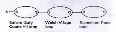
Walk outline
The walk has three loops.
The Castlemaine Diggings national Heritage Park
At Chewton, gold was first discovered in 1851 near the junction of Sailors Gully and Forest Creek. Over the next few years thousands of diggers flocked to the area.
The first miners worked the shallow alluvial diggings, where gold was easily obtained from shallow shafts.
A parallel series of quartz reefs cross the Chewton goldfields, aligned in a north-south direction. The reefs in the area include Quartz Hill Reef, Big Hill Reef, Ophir Reef, Sailors (or Garfield) Reef, and Sheepshead Reef.
The richness of the alluvial diggings was the result of gold weathering from the quartz reefs over millions of years.
When the surface gold was depleted, the search turned to gold enclosed in quartz reefs. The quartz was removed using open cuts or shafts. It was crushed into a fine sand, and the gold extracted from the sand. Most of the crushing plants were operated using steam power. Garfield was an exception, and used water.
The most prominent quartz outcrop was at Quartz Hill. Most of the quartz from the hill has been removed by miners.
The supply of water was a problem for the early miners. Expedition Pass Reservoir was constructed to supply water to mines. It also supplied water for the Garfield Wheel. The water was carried by channels (or water races). One of these races can be seen on parts of the the walk.
In the 1800s there were many houses throughout the diggings. Sometimes the remains of a stone fireplace, or remnants of a garden, are the only indications of a former dwelling.
Garfield Water Wheel to Expedition Pass Walk Map
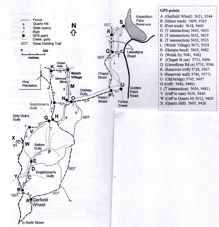
Walk notes
A. Garfield Wheel. The walk starts at the notice board near the foundations of the water wheel. The track leads north (320 degrees).
B. Minor track. After joining the main road, continue north for 20 m and take the minor 4WD track that leads off to the right (20 degrees).
C. Englishman's Gully. Cross the branch of Sailors Gully.
D. Fork Take the left fork (350 degrees)
E Foot track leads off to the right (10 degrees), and follows Sailors Gully, with the gully floor on the left. The track passes the ruins of a blacksmith's shop.
F. Puddling machine. The foot track then leads then northward, along a branch of Sailors Gully, and then along a ridge between two gullies.
G. T intersection. Turn right (40 degrees) along the 4WD track. Scotchman's Gully is on the north side.
H. T intersection. At the intersection, turn left (20 degrees). Scotchman's Gully is on the left.
I. T intersection. Continue north (350 degrees).
J. Branch in track. Keep right.
K. T intersection. Turn right (80 degrees) beside Golden Gully and walk downhill to the village.
L. Welsh Village. Some of the ruins are visible. Most of the village is on private property, east of the fence.
Turn right and follow the track to the south side of the ruins, keeping to the right (west) of the branch of Golden Gully. The narrow track leads from the ruin (190 degrees), and climbs to a crest. Keep right (west) of the fence line. There are many mining relics and a large slate quarry along the route.
M. Crest and a view over the Forest Creek valley to the ridge line which marks the boundary of the Ordovician sediments and the Harcourt granite.
N. Hairpin bend. The track descends (90 degrees) into a Welsh St.
O. Welsh St. Formerly Called Donkey Gully Track.
[From here, you may continue to Expedition Pass Reservoir (about 3 km return), or return to the Garfield Wheel]
Continue eastwards along Welsh St (80 degrees), with Donkey Gully on the left, for 500 metres.
P. Intersection of Welsh St and Chapel St. Turn left (50 degrees) along Chapel Street.
Q. Llewellyns Road. At Llewellyns Road corner continue northwards (350 degrees).
R. End of the orchard. Cross the fence and continue north-wards along the edge of Forest Creek. Follow the narrow track over the crest, to the reservoir.
S. Expedition Pass Reservoir. If safe, cross to the embankment and return along the track (220 degrees) to Llewellyns Road.
T. Walk to Ruined Bridge. Follow the narrow track from Llewellyns Road (on the east of the creek) to the ruined bridge. The creek follows the creek and passes through revegetation sites.
U. Ruined Bridge. Turn right (west) along the embankment.
P. East end of Welsh St (revisited). Continue west.
O. West end of Welsh St (revisited). Take the track uphill (240 degrees), near the Welsh Village sign. The track leads to some slate quarries. Keep right and continue uphill along the 4WD track.
I (revisited). Turn left (170 degrees).
H (revisited). (240 degrees) and continue following this 4WD track.
V. Ruin and walled garden. A ruin with a walled garden is about 30 metres from the track, behind the ruins of a stone-lined pit.
W. T intersection. Turn right(310 degrees) to Quartz Hill.
X. Quartz Hill open cut. Quartz has been removed by gold miners.
U turn and return to the T intersection and follow the main road southwards (210 degrees).
Y. Sailors Gully crossing.
B. Cross Roads. Turn left and follow the track to the Garfield Wheel.
Location
Leanganook Track, Chewton 3451 View Map
Web Links
→ www.parks.vic.gov.au/places-to-see/sites/garfield-water-wheel


")