Castlemaine - Forest Creek Gold Diggings



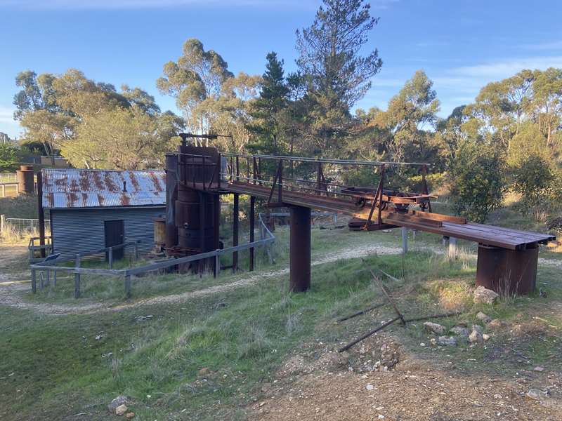
In late 1851 and early 1852, the first year of the Mount Alexander gold rush, tens of thousands of prospectors poured into the broad valley of Forest Creek. They spread out along the tributaries flowing into the creek and followed them up into the hills. Some of them came here, to a former course of Forest Creek.
In March 1852, White Hill (stops 3–5 on the walk) was the scene of a rush within a rush. A month later, Red Hill (stops 8–10) was also swarming with prospectors, some lying flat out on the ground to secure their eight foot by eight foot claim (about 2.4 square metres).
Mining of alluvial gold (gold washed downstream from its source into rivers and floodplains) continued here for over 100 years. In the early years, miners dug into the creek bed and washed the soil and gravel by hand. Over time, they developed more efficient, mechanised methods to make the process easier.
The miners at Forest Creek used a range of methods to wash gold from the rock and soil – including panning, cradling, puddling, surfacing and sluicing. All have left traces in the landscape for you to see and learn about on the walk.
Discover how generations of miners won gold from the rich alluvial ground along Forest Creek on this 400m circuit self-guided walk with interpretive signs.
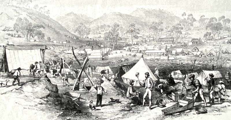
Forest Creek at the peak of the gold rush viewed from Adelaide Hill. Source: State Library of Victoria.
The landscape here shows the environmental impacts of various types of alluvial gold mining, including shaft sinking, tunnelling and hydraulic sluicing. Enjoy a picnic, explore the geomaze, pan for gold in the dam near the carpark and see one of Victoria's unique mining gems - a massive Ruston and Hornsby gas engine, used to pump large volumes of water at the cliff-face to extract gold.
Forest Creek Gold Diggings Walk
Grade 2, 400 m circuit, allow 30–60 minutes
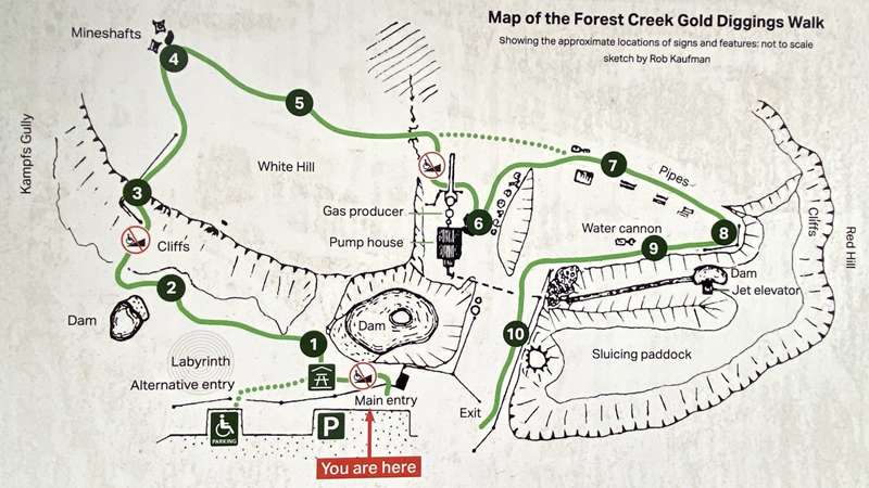
Gravel path with mostly gentle slopes. There are three short steeper sections with gradients of 1:5 that may be challenging for people with mobility aids. These can be avoided by using the alternative entry point and following the recommendations on the sign there. This doubles the length of the walk. If you are unable to read all the signs today, download the Forest Creek Gold Diggings heritage notes from the park webpage via the QR code.
This self-guided walk takes you on a journey through time from the early gold diggings of the 1850s (features 1–4) through to the large-scale sluicing of the 1930s to 1950s (features 6–10).
Ten signs explain the mining features and technology from the perspective of people that worked, or might have worked here. Alf Cox and his father, Chris and Maxine McHendry and Joseph Brady are real people. Their achievements and life events are told as accurately as possible. The rest of the characters – including Alf's friend Jim – are fictional. However, their stories and experiences reflect real events and historical accounts of what life was like at that time.
1. A Drop of Luck
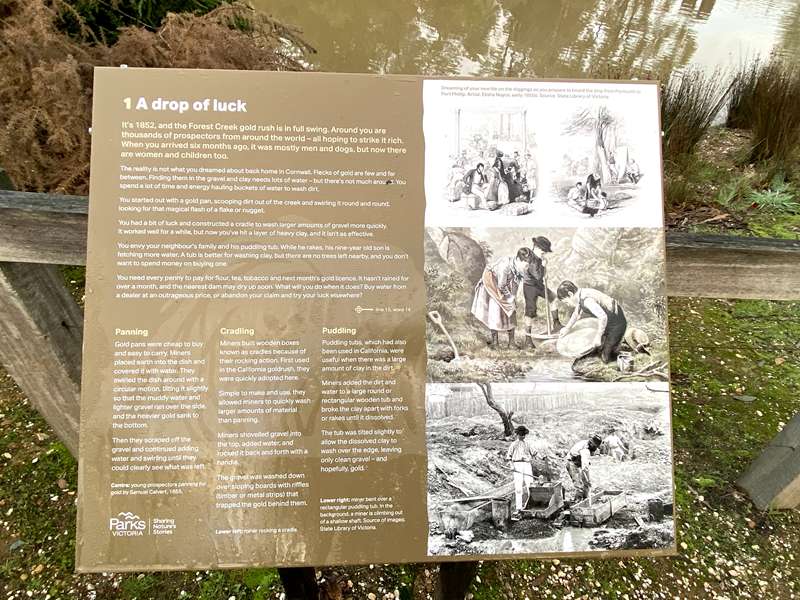
It's 1852, and the Forest Creek gold rush is in full swing. Around you are thousands of prospectors from around the world – all hoping to strike it rich. When you arrived six months ago, it was mostly men and dogs, but now there are women and children too.
The reality is not what you dreamed about back home in Cornwall. Flecks of gold are few and far between. Finding them in the gravel and clay needs lots of water – but there's not much around. You spend a lot of time and energy hauling buckets of water to wash dirt.
You started out with a gold pan, scooping dirt out of the creek and swirling it round and round, looking for that magical flash of a flake or nugget.
You had a bit of luck and constructed a cradle to wash larger amounts of gravel more quickly. It worked well for a while, but now you've hit a layer of heavy clay, and it isn't as effective.
You envy your neighbour's family and his puddling tub. While he rakes, his nine-year-old son is fetching more water. A tub is better for washing clay, but there are no trees left nearby, and you don't want to spend money on buying one.
You need every penny to pay for flour, tea, tobacco and next month's gold licence. It hasn't rained for over a month, and the nearest dam may dry up soon. What will you do when it does? Buy water from a dealer at an outrageous price, or abandon your claim and try your luck elsewhere?
Panning
Gold pans were cheap to buy and easy to carry. Miners placed earth into the dish and covered it with water. They swirled the dish around with a circular motion, tilting it slightly so that the muddy water and lighter gravel ran over the side, and the heavier gold sank to the bottom.
Then they scraped off the gravel and continued adding water and swirling until they could clearly see what was left.
Cradling
Miners built wooden boxes known as cradles because of their rocking action. First used in the California goldrush, they were quickly adopted here.
Simple to make and use, they allowed miners to quickly wash larger amounts of material than panning.
Miners shovelled gravel into the top, added water, and rocked it back and forth with a handle.
The gravel was washed down over sloping boards with riffles (timber or metal strips) that trapped the gold behind them.
Puddling
Puddling tubs, which had also been used in California, were useful when there was a large amount of clay in the dirt.
Miners added the dirt and water to a large round or rectangular wooden tub and broke the clay apart with forks or rakes until it dissolved.
The tub was tilted slightly to allow the dissolved clay to wash over the edge, leaving only clean gravel – and hopefully, gold.
2. Millions of years in the making
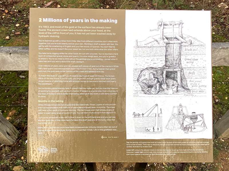
It's 1853, and most of the gold at the surface has already been found. The ancient creek bed extends above your head, at the level of the cliff in front of you. It has not yet been washed away by hydraulic sluicing.
You've teamed up with a miner from Chile. Men from different countries don't often work together, but you're both twenty and on your own. Working a shaft is easier with two. You get by with his smattering of English and your few words of Spanish. You don't like his bitter coffee, and he doesn't like your sweet tea, but you both drink what the other offers.
You take turns digging while the other hauls dirt out with a bucket. You've reached a hard layer of compacted gravel, stone and quartz. It is slow, tough work, and you're grateful to share it. You're too tired to think about the geology you're excavating – except when it rains hard and you worry about the shaft caving in.
Over millions of years, wind and rain eroded soft pieces of gold out of the cracks in White Hill's hard quartz and washed them down into Forest Creek. Being heavier than gravel and mud, the gold sank to the bottom of the creek and settled in the clay.
To reach this layer of "pay-dirt" you'll need to dig down at least 1.5 metres. You're two-thirds of the way there. If you're lucky, you might find enough gold to never work again. Jorge dreams of returning home with enough money to become a ranchero and marry his sweetheart.
You're thinking about staying here. It doesn't feel like home yet, but you love the freedom of working for yourself, with as much chance of reward as anyone else. Even a bad day in the heat of Forest Creek is better than being yelled at all day down a cold damp Cornish tin mine.
Months in the taking
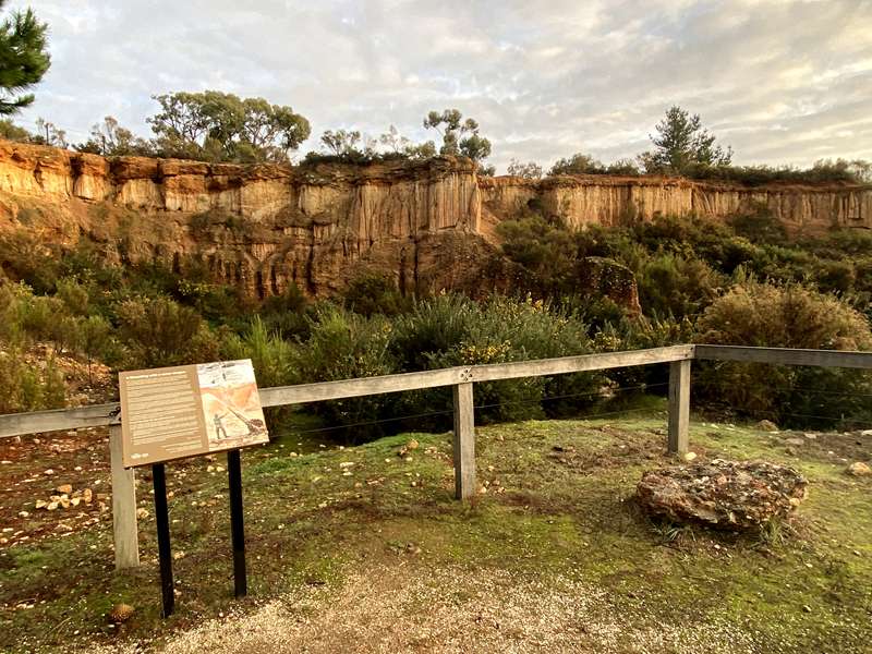
White Hill was extremely rich in gold and was intensively mined. Layers of rock and dirt that had accumulated over millions of years were stripped away in months. The sheer cliff face here is the result of hydraulic sluicing. This technique used high-pressure jets of water to wash away large amounts of soil. You can learn more about it from signs 6–10.
Look at the mineshaft in the cliff. Follow it down on the left-hand side and you can see the blue grey clay of the creek bed. Perhaps this shaft was one of the lucky ones that found pay-dirt?
Many didn't, and failure could have fatal consequences. Unlucky miners often ran out of money and became destitute. Some died or lost their minds. Life on the goldfields was hard.
3. Reworking, reclaiming, renaming
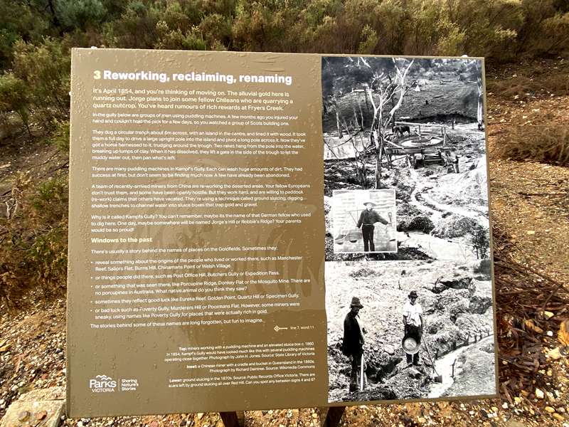
It's April 1854, and you're thinking of moving on. The alluvial gold here is running out. Jorge plans to join some fellow Chileans who are quarrying a quartz outcrop. You've heard rumours of rich rewards at Fryers Creek.
In the gully below are groups of men using puddling machines. A few months ago you injured your hand and couldn't hold the pick for a few days, so you watched a group of Scots building one.
They dug a circular trench about 6 m across, with an island in the centre, and lined it with wood. It took them a full day to drive a large upright pole into the island and pivot a long pole across it. Now they've got a horse harnessed to it, trudging around the trough. Two rakes hang from the pole into the water, breaking up lumps of clay. When it has dissolved, they lift a gate in the side of the trough to let the muddy water out, then pan what's left.
There are many puddling machines in Kamp's Gully. Each can wash huge amounts of dirt. They had success at first, but don't seem to be finding much now. A few have already been abandoned.
A team of recently-arrived miners from China are re-working the deserted areas. Your fellow Europeans don't trust them, and some have been openly hostile. But they work hard, and are willing to paddock (re-work) claims that others have vacated. They're using a technique called ground sluicing, digging shallow trenches to channel water into sluice boxes that trap gold and gravel.
Why is it called Kamp's Gully? You can't remember, maybe it's the name of that German fellow who used to dig here. One day, maybe somewhere will be named Jorge's Hill or Robbie's Ridge? Your parents would be so proud!
Windows to the past
There's usually a story behind the names of places on the Goldfields. Sometimes they:
- reveal something about the origins of the people who lived or worked there, such as Manchester Reef, Sailors Flat, Burns Hill, Chinamans Point or Welsh Village.
- or things people did there, such as Post Office Hill, Butchers Gully or Expedition Pass.
- or something that was seen there, like Porcupine Ridge, Donkey Flat or the Mosquito Mine. There are no porcupines in Australia. What native animal do you think they saw?
- sometimes they reflect good luck like Eureka Reef, Golden Point, Quartz Hill or Specimen Gully.
- or bad luck such as Poverty Gully, Murderers Hill or Poormans Flat. However, some miners were sneaky, using names like Poverty Gully for places that were actually rich in gold.
4. Shafted
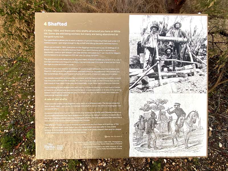
It's May 1854, and there are mine shafts all around you here on White Hill. Some are still being worked, but many are being abandoned as the gold runs out.
Your gold licence allows you to work a section of ground measuring 8 feet (just under 2.5 metres) square - just large enough to dig a shaft and pile up the earth removed from it.
When you arrived in 1852, everyone on the diggings was forced to pay 30 shillings (£1.5 British Pounds) for a month's licence. Even if you didn't find any gold, or worked as a blacksmith, cook or tent-keeper. Last year the fee went down to £1 per month for diggers but increased to an outrageous £50 per year for shop-keepers.
The gold licence only allows you to dig your claim. It doesn't entitle you to land or to vote. It isn't fair and there are frequent protests. Farmers only pay £10 a year in land tax but have the right to vote and build a home.
You must carry your licence at all times. If you're caught without it, you'll be arrested and fined £5. Half goes to the government, and half is kept by the policeman who arrests you. Not surprisingly, there are frequent checks and arrests. If you can't pay, you'll be jailed.
You deeply resent being treated like a criminal, and the heavy-handed (sometimes violent) way the police enforce the licences. You don't cop it as badly as the Chinese, but you've lost count of how many times you, and especially Jorge, have had to show your licences.
You're starting to feel disillusioned with mining. Is it worth moving on in the hope of better prospects, or should you quit and look for work on a sheep station or in one of the growing towns? You'd love to have regular pay, but what if you end up with a boss who treats you even worse than the police?
A tale of two shafts
There are two shafts close together here, each on a different claim. The fences show the size of each claim - just under 2.5 metres. One shaft is round, the other is rectangular. Can you guess why?
A popular theory was that Cornish miners dug rectangular shafts, and Chinese miners dug round shafts because they were suspicious of evil spirits hiding in corners. However, this is not true - Chinese miners also dug rectangular shafts. The only suspicions that came into it were those of European miners towards the Chinese.
The different shapes are due to individual preference and the shape and geology of the claim. A circular shaft made better use of a square claim and was safer in less stable ground. A rectangular shaft may have been better in an oddly shaped claim and for deeper shafts reinforced with wooden struts and planks.
5. A barren and desolate place
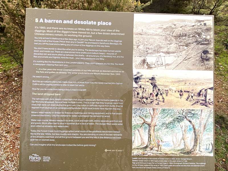
It's 1860, and there are no trees on White Hill to block your view of the diggings. Most of the diggers have moved on, but a few dozen determined Chinese miners remain, re-working the ground.
You only arrived in Melbourne a few days ago, to join your fiancé. Huw did well on the diggings and has built a fine house ("Nicer than any in Cardiff!" he promises) in Sandhurst (Bendigo). He met you off the boat and is taking you on a tour of the diggings on the way there.
You don't have words to describe what you're seeing. The landscape has been turned upside down, and inside out. There are abandoned mine shafts and mullock heaps - mounds of discarded dirt and stone piled up between the shafts—all around you. It's fiendishly hot, and the flies and smells are frightful. And the mud... your skirts and boots are filthy.
It's nothing like the illustrations in the London papers. They didn't prepare you for this. You recall a newspaper clipping Huw sent you:
"...in a few years the wood-crowned summits of our hills will look as desolate and barren as the flats and gullies do already." the writer predicted in the Mount Alexander Mail, 1855.
He wasn't wrong.
But this apocalyptic place has made Huw rich. A week from now, the newly-married Mrs Gaynor Collins will be paying someone else to wash her skirts.
How far you've come from being a lady's maid in Cardiff!
The land stripped bare
The tall trees with dark, deeply rutted bark that you just passed are Red Ironbarks (yeerrip in Dja Dja Wurrung language). Several have multiple trunks. This is a sign that they've grown back from trees that were cut down during the gold rush. Like tulips or daffodils regrow from bulbs, they've regrown from stumps or an underground lignotuber. Most local forests have regrown this way.
Miners relied heavily on timber for firewood, buildings and mining equipment, and to fuel steam-powered machinery. Only the demand for water outstripped the demand for wood.
Water was crucial. Miners needed it to drink, cook and wash with, and to separate gold from soil and gravel. Work often had to stop in summer due to lack of water. The sludge-filled waste water soon silted up streams and waterholes.
Today, the Forest Creek Gold Diggings reflect what much of the goldfields would have looked like by the late 1850s, but less muddy and chaotic. You are standing on one of the last remnants of the ancient creek bed, and all the ground between you and the hills in the distance has been quarried or washed away.
Can you imagine what the landscape looked like before gold mining?
6. Pumping water, providing hope
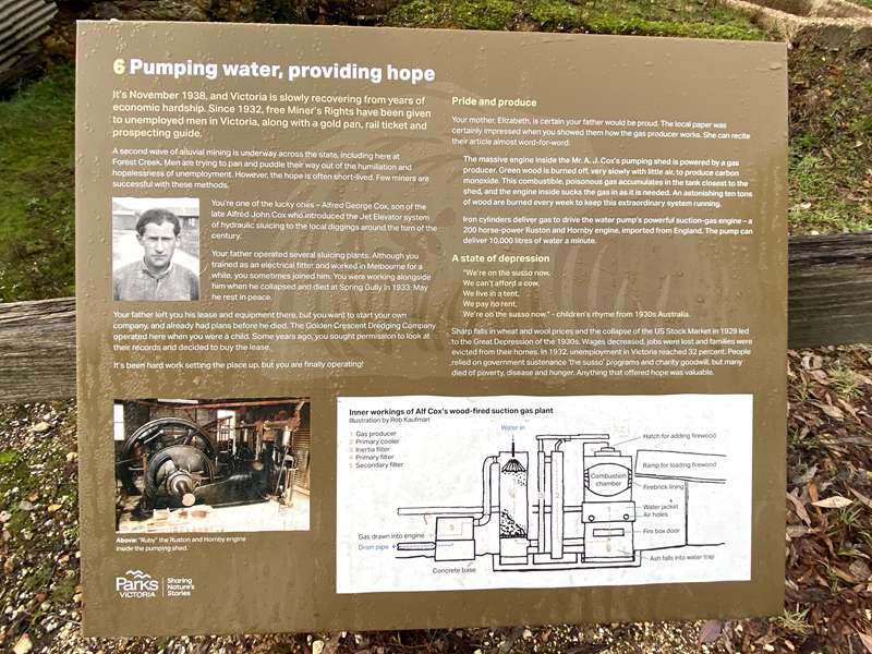
It's November 1938, and Victoria is slowly recovering from years of economic hardship. Since 1932, free Miner's Rights have been given to unemployed men in Victoria, along with a gold pan, rail ticket and prospecting guide.
A second wave of alluvial mining is underway across the state, including here at Forest Creek. Men are trying to pan and puddle their way out of the humiliation and hopelessness of unemployment. However, the hope is often short-lived. Few miners are successful with these methods.
You're one of the lucky ones – Alfred George Cox, son of the late Alfred John Cox who introduced the Jet Elevator system of hydraulic sluicing to the local diggings around the turn of the century.
Your father operated several sluicing plants. Although you trained as an electrical fitter and worked in Melbourne for a while, you sometimes joined him. You were working alongside him when he collapsed and died at Spring Gully in 1933. May he rest in peace.
Your father left you his lease and equipment there, but you want to start your own company, and already had plans before he died. The Golden Crescent Dredging Company operated here when you were a child. Some years ago, you sought permission to look at their records and decided to buy the lease.
It's been hard work setting the place up, but you are finally operating!
Pride and produce
Your mother, Elizabeth, is certain your father would be proud. The local paper was certainly impressed when you showed them how the gas producer works. She can recite their article almost word-for-word:
The massive engine inside the Mr. A. J. Cox's pumping shed is powered by a gas producer. Green wood is burned off, very slowly with little air, to produce carbon monoxide. This combustible, poisonous gas accumulates in the tank closest to the shed, and the engine inside sucks the gas in as it is needed. An astonishing ten tons of wood are burned every week to keep this extraordinary system running.
Iron cylinders deliver gas to drive the water pump's powerful suction-gas engine – a 200 horse-power Ruston and Hornby engine, imported from England. The pump can deliver 10,000 litres of water a minute.
A state of depression
"We're on the susso now,
We can't afford a cow,
We live in a tent,
We pay no rent,
We're on the susso now." – children's rhyme from 1930s Australia.
Sharp falls in wheat and wool prices and the collapse of the US Stock Market in 1929 led to the Great Depression of the 1930s. Wages decreased, jobs were lost and families were evicted from their homes. In 1932, unemployment in Victoria reached 32 percent. People relied on government sustenance ('the susso' programs) and charity goodwill, but many died of poverty, disease and hunger. Anything that offered hope was valuable.
7. Moving massive amounts of water
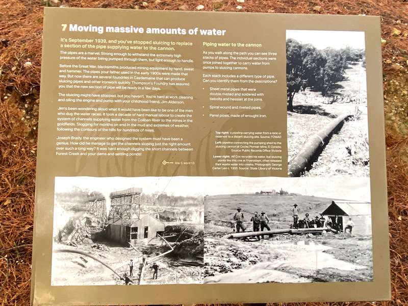
It's September 1939, and you've stopped sluicing to replace a section of the pipe supplying water to the cannon.
The pipes are a marvel. Strong enough to withstand the extremely high pressure of the water being pumped through them, but light enough to handle.
Before the Great War, blacksmiths produced mining equipment by hand, sweat and hammer. The pipes your father used in the early 1900s were made that way. But now there are several foundries in Castlemaine that can produce sluicing pipes and other ironwork quickly. Thompson's Foundry has assured you that the new section of pipe will be ready in a few days.
The sluicing might have stopped, but you haven't. You're hard at work cleaning and oiling the engine and pump with your childhood friend, Jim Alderson.
Jim's been wondering aloud what it would have been like to be one of the men who dug the water races. It took a decade of hard manual labour to create the system of channels supplying water from the Coliban River to the mines in the goldfields. Slogging for months on end in the mud and extremes of weather, following the contours of the hills for hundreds of miles.
Joseph Brady, the engineer who designed the system must have been a genius. How did he manage to get the channels sloping just the right amount over such a long way? It was hard enough digging the short channels between Forest Creek and your dams and settling ponds!
Piping water to the cannon
As you walk along the path you can see three stacks of pipes. The individual sections were once joined together to carry water from pumps to sluicing cannons.
Each stack includes a different type of pipe. Can you identify them from the descriptions?
- Sheet metal pipes that were double riveted and soldered with tiebolts and hessian at the joins.
- Spiral wound and riveted pipes.
- Panel pipes, made of wrought iron.
8. Wrestling with a water dragon
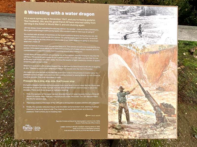
It's a warm spring day in November 1947, and you're feeling grateful. Your husband, Jim, and his good friend Alf have returned safely from serving in the RAAF in World War II, and are sluicing again.
Jim has always loved operating the sluicing cannon. No wonder – look at it there, behind you, like a giant metal dragon (without the teeth). Who wouldn't want to have a go at using it?
You worked with all kinds of machinery in the local munitions factory during the war, but Jim doesn't believe you could handle the cannon. So, you've challenged him to a bet. He and Alf can't stop laughing as they show you how to use it, but Helen Alderson's going to show them what she's made of.
It isn't as hard as it looks once you get the hang of it. The cannon is built to be operated by one person. Articulated joints allow you to direct the powerful jet of water where required, and the counterbalance stops the nozzle from bouncing around and hurting you.
10,000 litres of water a minute are pumping out of the cannon, steadily forcing its way into the cliff face. The jet is strong enough to cut a person in two. On a still night, you can hear its roar all the way from home, two miles away. You love the sparks of light created by chunks of quartz smashing against each other.
What fun it is to work with a water dragon! You're reluctant to hand it back to Alf, who is laughing at Jim. "Shame on you for not believing in Helen!" he shouts over the roar of the water.
Jim owes you a pie and ale at the Red Hill tavern and a trip to the pictures in Castlemaine. He pretends to be outraged, but you know he's looking forward to seeing Miracle on 34th Street as much as you are. Only one more week to wait!
Pressure like a drip, drip, drip, that'll never stop
It's hard to imagine how strong the pressure must have been to scour away Red Hill. Rivers take thousands of years to erode a gorge, but one side of Red Hill was washed away in only a few decades. There were three stages to hydraulic sluicing:
- First, the operator of the water cannon directed the jet of water towards the top of the cliff. About 30 metres away from you now, but much closer back then. The cliff was saturated like this for several days.
- Then they undercut the base of the cliff with a strong blast of water until the cliff collapsed.
- Finally, the operator directed the jet onto the fallen soil and broken rock, washing it along a channel to the sump (sluice hole). The channel and sump were known as a sluicing paddock. That's where you're heading next.
9. Sifting through the soggy mess
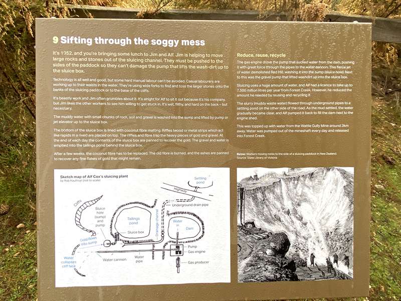
It's 1952, and you're bringing some lunch to Jim and Alf. Jim is helping to move large rocks and stones out of the sluicing channel. They must be pushed to the sides of the paddock so they can't damage the pump that lifts the wash-dirt up to the sluice box.
Technology is all well and good, but some hard manual labour can't be avoided. Casual labourers are working up to their waists in the water. They're using wide forks to find and toss the larger stones onto the banks of the sluicing paddock or to the base of the cliffs.
It's beastly work and Jim often grumbles about it. It's alright for Alf to sit it out because it's his company, but Jim likes the other workers to see him willing to get stuck in. It's wet, filthy, and hard on the back – but necessary.
The muddy water with small chunks of rock, soil and gravel is washed into the sump and lifted by pump or jet elevator up to the sluice box.
The bottom of the sluice box is lined with coconut fibre matting. Riffles (wood or metal strips which act like rapids in a river) are placed on top. The riffles and fibre trap the heavy pieces of gold and gravel. At the end of each day the contents of the sluice box are panned to recover the gold. The gravel and water is emptied into the tailings pond behind the sluice box.
After a few weeks, the coconut fibre has to be replaced. The old fibre is burned, and the ashes are panned to recover any fine flakes of gold that might remain.
Reduce, reuse, recycle
The gas engine drove the pump that sucked water from the dam, pushing it with great force through the pipes to the water cannon. This fierce jet of water demolished Red Hill, washing it into the sump (sluice hole). Next to this was the gravel pump that lifted wash-dirt up into the sluice box.
Sluicing uses a huge amount of water, and Alf had a licence to take up to 7,500 million litres per year from Forest Creek. However, he reduced the amount he needed by reusing and recycling it.
The slurry (muddy waste water) flowed through underground pipes to a settling pond on the other side of the road. As the mud settled, the water gradually became clear, and Alf pumped it back to fill the dam next to the engine shed.
This was topped up with water from the Wattle Gully Mine around 3 km away. Water was pumped out of the mineshaft every day and released into Forest Creek.
10. Preservation and perception
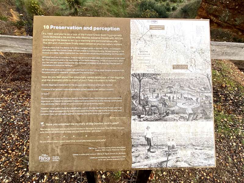
It's 1997, and you're on a tour of the Forest Creek Gold Diggings with Chris McHendry. He and his wife, Maxine, became friends with Alf Cox and bought his lease to set up a teaching and demonstration site. The dirt and chaos have finally been tamed so you can safely explore.
Chris explains that the Wattle Gully Mine changed hands in the late 1950s, and stopped pumping water into Forest Creek. Alf was unable to continue sluicing. He kept paying for the licence and water rights hoping that the new owners would resume pumping, but they didn't.
Alf found work as a consultant, fixed things at the local gas plant, and processed scrap metal for Thompson's Foundry. He kept some of the more interesting pieces of equipment, which you can still see spread around the site. Although unrelated to his sluicing, they are part of Castlemaine's industrial heritage.
Alf eventually gave up the water right, but held on to the mining lease despite pressure from the government to release it, until he met the McHendrys.
How do you feel about the intensively mined landscape of the diggings, and the dramatic cliffs in front of you? Take a moment to reflect.
Are the diggings a testament to the dogged determination of the gold miners?
Evidence of an ancient cultural landscape turned upside down without consent?
Or both?
The technology and techniques used at the Forest Creek Gold Diggings were undeniably ingenious and helped to establish Castlemaine and Chewton as the thriving communities they are today. Many locals are proud of their rich gold mining history.
However, mining also came at a devastating cost to the Dja Dja Wurrung People and their Country. We encourage you to learn more about this from the sign in the picnic area, and consider: how can we walk together in healing the scars mining left behind?
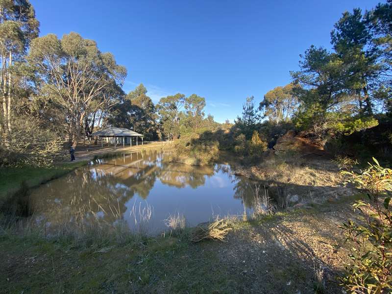
Labyrinth
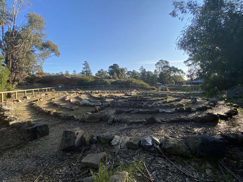
The Forest Creek labyrinth has eight concentric circles of rocks. Six types of rocks represent the main periods of geological activity in Central Victoria. The oldest are around the edge and the youngest are in the centre.
The two outer circles are sandstone and shales that were laid down on the ocean floor when this region was still below sea level (around 480 million years ago).
The third circle consists of slate which formed when the region was heated to 300°C about 440 million years ago. This changed and hardened the shale into slate.
The fourth circle has large blocks of white quartz, which formed just after the slate. This is what the miners were looking for - reefs (also known as veins or lodes) of quartz containing gold.
The fifth circle is black and white speckled Harcourt granodiorite, a type of granite. It formed 368 million years ago when hot molten granodiorite was pushed up towards the surface. It eventually cooled to form Mount Alexander (Liyanganuk). Located not far from here, it is a popular spot for camping, picnics and bushwalking.
The sixth circle is basalt. Over the past 7 million years, basalt lava has flowed from many volcanoes in central and western Victoria, including Mount Franklin (Lalgambuk) just south of the Castlemaine Diggings.
The two inner circles are conglomerate - a mixture of all sorts of older rocks bonded together with cement-like clay and sand. This formed in ancient riverbeds between 40 million to 3 million years ago.
Access to Forest Creek Gold Diggings Site:
The site is easily accessible by road. There is a car park off the Pyrenees Highway / Duke Street at the eastern end of Castlemaine.
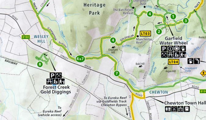
For walkers, access is via a 300m detour off the (4) Pennyweight Flat Cemetery Walk, (7) Forest Creek Trail or Goldfields Track (walking and biking). Parking is available off Prendergast Street.
From the Garfield Water Wheel Trailhead, follow the Goldfields Track towards Castlemaine, turning south (left) at Farran Street and crossing the Pyrenees Highway (2.7km one-way).
Forest Creek Gold Diggings Map
Forest Creek Gold Diggings Walk is labelled (8) on the map.
Access for Dogs:
Dogs must be kept on a lead and under control at all times. Please collect and remove your dog's droppings for the sake of other visitors and to avoid stress to native animals.
Please note that the Nimrod Reef Mine and Welsh Village is a designated Special Protection Area due to its historic significance, so the (6) Welsh Village Walk is not marked or signed through that area. Dogs and bikes are prohibited.
Safety:
The Castlemaine Diggings are a heavily mined landscape and contain a variety of ongoing hazards, including uneven and unstable ground, mineshafts, open cuts, quarries, and mine tailings. For your own safety, please stay on mapped tracks and supervise children. Comply with local signs and do not climb over or around barriers and fences or on the stone foundations of the water wheel.
Take care in and around the dam. Always actively supervise children near water.
Review:
This is a very interesting site, which is easily accessible off the highway, which shows how alluvial gold mining was conducted. There is lots of old mining equipment scattered around the site and a labyrinth. There is also information about how the mining adversely affected the local Indigenous Dja Dja Wurrung People.
At the carpark there is a picnic table and toilets.
Site Signage
Womindjika - Welcome to Forest Creek
You are standing on the lands of Djaara (Dja Dja Wurrung People). This Country, Djandak, is a diverse landscape characterised in some parts by Box Ironbark Forest, others by barren rocky soils, and in others by grassy plains. Djandak provided Djaara with everything they could possibly need to thrive here – it was the pantry, the pharmacy and the hardware store all in one.
Gold Rush
Our Ancestors helped Europeans find their way through our Country. We guided them along tracks that were used for trading with other mobs. When they found gold, our old people were surprised by the excitement. While Djaara always knew about the abundant yellow mineral, gara (gold), it was too soft to be useful for making spear tips, for grinding or for cutting tools.
The gold rush devastated Djandak. Particularly harmful were the excavation methods that European miners used to extract gold from the earth in 1851 to the late 1860s. Djaara were aggressively dispossessed of our lands and forced onto missions where families were separated and the practice of Culture banned. The Dja Dja Wurrung language was nearly lost. Access to Djandak and rights to care for Country were returned to Djaara with the signing of the Recognition and Settlement Agreement in 2013.
Djaara Today
Today, Djaara descend from 18 Apical Ancestors, the only traceable survivors of colonialist through written records. While there were likely more survivors, we honour these 18 with the collection of rocks you see here at Forest Creek. Uncle Rick Nelson is a respected Elder in this local area. He and his family are descended from Henry Harmony Nelson.
"Djaara Country is a land steeped in heritage. This rugged terrain, with its extremes of climate, hosts many significant cultural sites. From scar trees to water wells, grinding stones to maker trees, it narrates a rich history of Djaara, deeply connected to this rugged yet beautiful landscape." - Uncle Rick Nelson, Dja Dja Wurrung Elder.
Upside-down Country
Djaara now sadly call this area of Djandak upside-down Country. This describes the literal exposure of the seams of quartz and granite that had been deep underground for millennia. It also captures the sickness that is the absence of native flora and fauna, the disruption and pollution of water. All of this is still evident as you explore Forest Creek. Keep an eye out for signs of rehabilitation as we combine Djaara Traditional Knowledge with contemporary landscape science to return health to Country.
Photos:
Location
164 Duke Street, Castlemaine 3450 View Map
Web Links
→ Forest Creek Heritage Notes (PDF)
→ www.parks.vic.gov.au/places-to-see/sites/forest-creek-gold-diggings


