Camperdown - Mount Leura & Mount Sugarloaf Reserves Walking Trails



Walking Trail Network
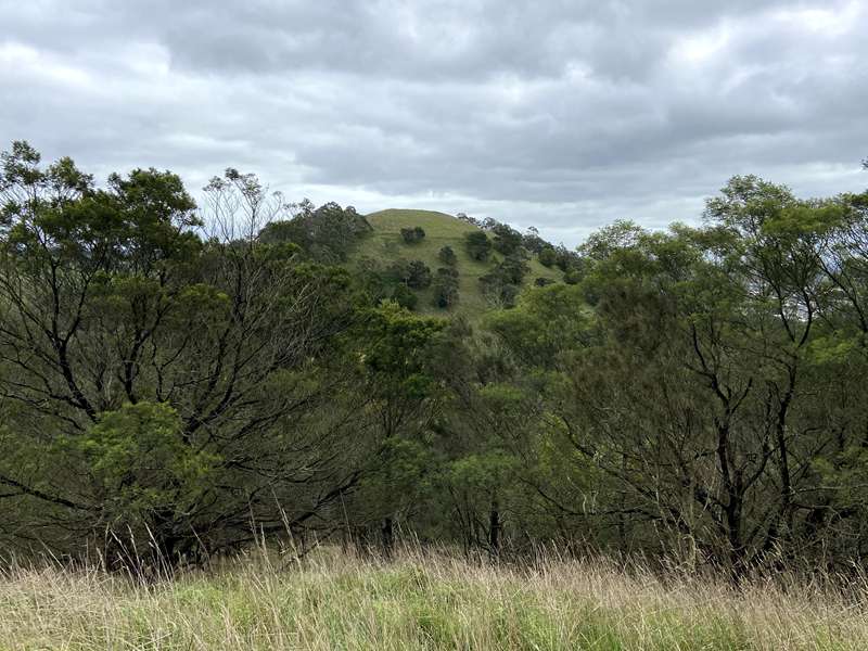
As shown on the map below, there is an extensive network of walking trails within these two adjoining reserves. Take a walk to the peaks of the two main volcanic cones – Mt Leura and Mt Sugarloaf – as well as to the very depths of the main crater; or to the scene of a major local conservation battle in the late 1960’s – the Sugarloaf quarry. All walks offer spectacular views of the volcanic landscape as well as the nearby township of Camperdown. Three shelters also offer the walker a chance to rest if required as well as take advantage of picnic facilities and interpretive displays.
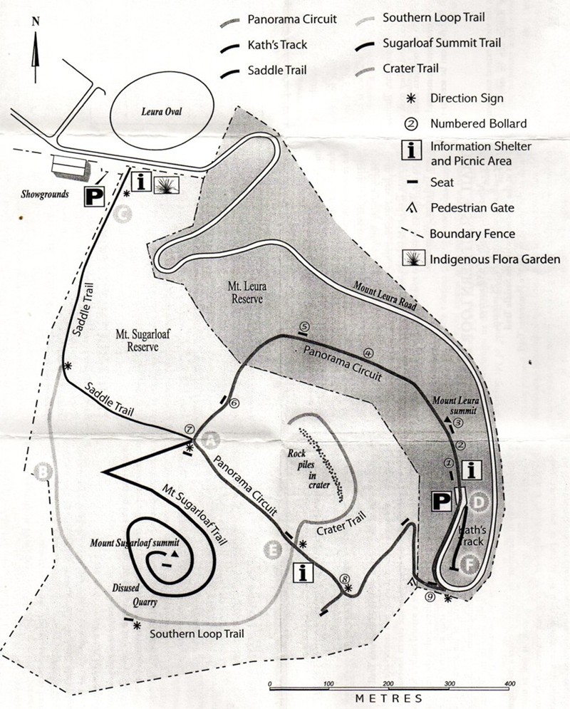
Trail Distances and Times
| Trail | Distance | Time (one way) |
|---|---|---|
| Panorama Circuit | 1.7km | 45min |
| Kath’s Track | 80m | 2 min |
| Saddle Trail | 650m | 15min |
| Southern Loop Trail | 850m | 25min |
| Sugarloaf Summit Trail | 1.0km | 15min |
| Crater Trail | 375m | 7min |
TRAIL 1: PANORAMA CIRCUIT
Easy - Moderate walk of 1.7km
Time - allow approximately 45 minutes for the complete circuit.
Start and finish at the Mt. Leura summit carpark
The following information is linked to the 9 numbered posts along this trail.
1 Rotary Shelter
This shelter was constructed in 1998 by the Rotary Club of Camperdown Inc.. Information about the volcanic trail and the Mt Leura/Mt Sugarloaf development project is displayed here. A more comprehensive display is available in the information shelter at the base of Mt Leura.
2 Crater View
Mt Leura and Mt Sugarloaf are the dominant features within the Leura nested maar and were formed somewhere between 10,000 - 40,000 years ago. Mt Sugarloaf was an almost perfect scoria cone, but is now scarred by a quarry on the western face. Scoria is the result of gaseous lava eruptions. Over time, these eruptions eventually formed the cone shaped hill. The original inhabitants of this area were the Leehura people. They called Mt Sugarloaf “Tuunumbee Hear” which translates to “moving moving woman”. The mounts were important landmarks, used for navigation on the plains beyond and as lookouts for monitoring game and movements of neighbouring people.
3 Trig Point
Mt Leura is 311 metres high and Mt Sugarloaf is slightly higher at 312 metres. The crater is approximately 100 metres deep from the highest points of the mounts. The collective area of the reserves is 50 hectares (124 acres). The establishment of the Mt Leura Reserve was the result of a land exchange between the Shire and the Manifold brothers in 1899. Mt Sugarloaf was acquired by the National Trust in 1972 in order to halt the destruction of the scoria cone by private quarrying. This site offers excellent views over the extensive volcanic plain which extends from the west of Melbourne through the southwest of the state to the South Australian border, in a belt approximately 100km wide. Many steep-sided scoria cones can be seen from here; among them Mounts Myrtoon, Elephant, Meningoort, Noorat and the Cloven Hills. Numerous lakes formed either directly or indirectly by volcanic activity are also clearly visible including Lakes Colongulac and Corangamite.
4 Exotic Tree Removal
Pine and Cypress were once planted above and below the access road to the summit as part of the WW1 Returned Soldiers’ Employment Scheme. Up till 1990 the view from the Trig Point across to Mt Sugarloaf was almost completely obscured by the pine trees. Almost all of these exotic trees have been removed from the reserves, and thousands of indigenous trees, shrubs and grasses have been planted in a community revegetation program begun in 1995. Wherever possible the timber has been re-used. The information shelter at the base of Mt Leura has been built from cypress removed from Mount Leura.
5 She-oak Seat
Some of these she-oaks are remnants of the original vegetation which once covered the mounts. The highest areas were sparsely covered in she-oaks, bursaria and banksia. Towards the base of the mounts the vegetation became thicker and more diverse. Manna gum and blackwood forest dominated this zone. Swamp gum and messmate with a shrubby understorey made up some of the diversity.
Look out for birds of prey: black-shouldered kites, nankeen kestrels, brown falcons, goshawks and wedge-tailed eagles. These birds of prey are often seen utilising the thermal updraughts created by the steep hillsides.
6 Revegetation Project
A variety of indigenous trees, shrubs and groundcovers have been replanted to restore the site to its pre-European condition. Silver banksia, drooping she-oak, manna gum, blackwood and black wattle are the main components of the tree layer. Tussock and wallaby grasses make up the main groundcover structure. Camperdown College Nursery has supplied almost all of the plants used in the revegetation process. Local seed was collected for propagation and the plants were raised by students and local residents. This revegetation program began in 1995.
7 Mount Sugarloaf Saddle
This is the junction of the Panorama Trail, the Sugarloaf Summit Trail and the Saddle Trail (to the Lower Information Shelter and Indigenous Demonstration Garden). See notes below regarding these other two trails.
8 Nested Maar Lookout Seat
Take a short 100m walk to the lookout seat; more features of the Leura ‘nested maar can be seen from this point. Each small hill is a separate scoria cone. There are a total of 24 scoria cones within the nested maar.
The first white settlers within the district were John, Thomas and Peter Manifold from Van Dieman’s Land. They took up a 100,000 acre run in 1839, based on the northern shore of Lake Purrumbete, and built the Purrumbete homestead in 1842. Lake Purrumbete and Mt Porndon can be seen to the east of this lookout.
9 Otways Views
From this point, on a clear day, the views extend southwards towards the coast. The Otway Ranges can be seen to the southeast.
TRAIL 2: KATH’S TRACK
Easy walk of only 80 metres
Time – allow approximately 4 minutes for the short walk - plus viewing time.
Start and finish at the Mt. Leura summit carpark
Take advantage of the seat to enjoy the magnificent views on offer from the end of this very short walk. Lake Purrumbete and Mt Porndon to the east; the smaller scoria cones nested within the volcanic maar to the south; Mt Sugarloaf and the 100m deep crater to the west.
TRAIL 3: SADDLE TRAIL
Easy - Moderate walk of 650 metres
Time – allow approximately 10 - 15 minutes.
Start at the Lower Information Shelter and Demonstration Garden.
Finish at the junction with the Panorama Trail.
This is a great place from which to start exploring the Reserves. The facilities at the start of this trail are major features of the Mt Leura and Mt Sugarloaf Reserves Project. Starting only as a grassy dairy paddock in 2000 this area has changed significantly. The indigenous trees were planted as part of the Olympic Tree Planting program, in honour of one of our local Olympians, the late Mr Bill Roycroft. In 2002 the shelter was constructed; 2003 saw the stone wall and interpretive displays added and in 2004 the demonstration garden of locally indigenous wildflowers and shrubs was commenced. Here is a great place to learn more about the revegetation that has taken place across the reserves, and the volcanic history of this National Trust listed site. It is also a great place for a picnic, with tables and seats provided.
From here you can walk to the Western Saddle to join the Panorama Trail - or to take the Sugarloaf Summit Trail. Before you get to the Western Saddle you will meet the start of the Southern Loop Trail (after 370 metres).
TRAIL 4: SOUTHERN LOOP TRAIL
Easy - Moderate walk of 650 metres
Time – allow approximately 20 - 25 minutes.
Start at the junction with the Saddle Trail
Finish at the junction with the Panorama Trail
This walk takes you past the disused Sugarloaf quarry – see details of conservation battle in the notes below. The quarry is now fenced for safety reasons. Looking at the top of the quarry it is possible to see areas that are slowly eroding further upwards. Over time it is almost certain that the quarry face will reach the summit of Mt Sugarloaf. The lower slopes of the quarry were revegetated in the 1970’s with native trees and shrubs (not indigenous) to hide the quarry face. The row of remaining pine trees were planted for the same reason.
Walking further takes you “around the back” of Mt Sugarloaf and near to Mount Chronicle located on an adjoining property. The trail also offers a very secluded view of the southern area of the maar which includes many smaller scoria cones. The trees in this area were planted in 2005 during a very dry period, but have grown exceptionally well.
After a short distance, you look down on the third and most recent of the information shelters. It has a wonderful interpretive display of the history of the site as well as an inspiring sculpture of nearby Mount Sugarloaf. At the end of the ‘Southern Loop’ you have joined the Panorama Trail.
TRAIL 5: SUGARLOAF SUMMIT TRAIL
Easy - Moderate walk of 1.0 km one way
Time – allow approximately 30 - 35 minutes for the return walk - plus viewing time.
Start and finish at the junction with the Panorama Trail
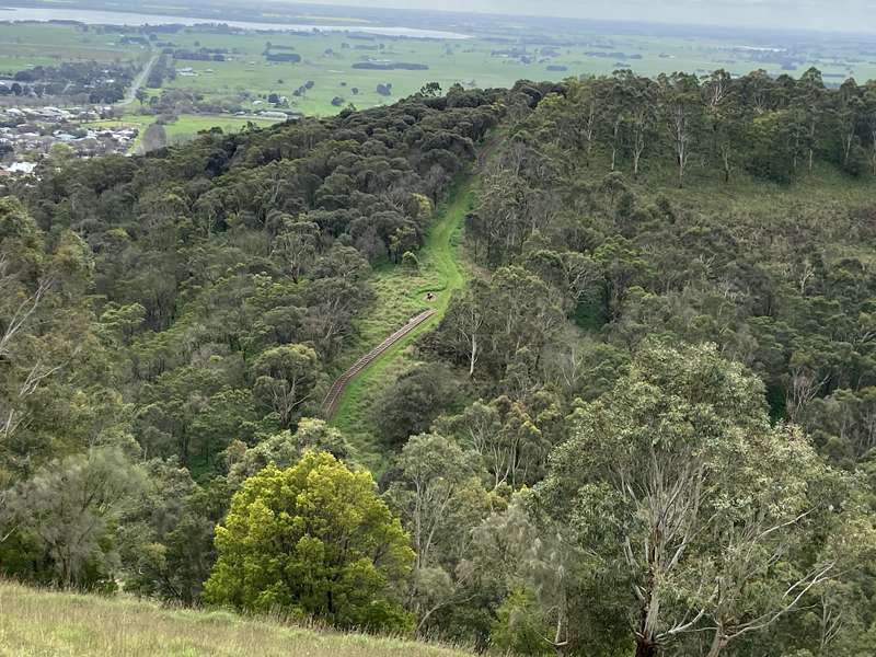
Mt Sugarloaf was saved from destruction in a conservation battle which set a precedent at the time - nowhere else in Australia had local people taken direct action to save a natural landmark. Local residents actually sat in front of a bulldozer during the battle to save the mount in 1969. The National Trust acquired the land in 1971 to prevent any further quarrying of the scoria and to guarantee the preservation of the remaining mount. Mt Sugarloaf is considered the best example of a scoria cone in the Western District.
Winding your way to the top of Mt Sugarloaf offers a 360 degree view of the surrounding landscape. This track, as well as many others across the Mt Sugarloaf Reserve, was constructed by the previous landowner as part of his farm management program. Today they provide ready made walking trails as well as access for emergency vehicles.
TRAIL 6: CRATER TRAIL
Easy - Moderate walk of 375 metres one way.
Time – allow approximately 10 - 15 minutes for the return walk
Start and finish at the junction with the Panorama Trail
Feel what it is like at the bottom of this 100 metre deep crater and enjoy the solitude. Can you guess how the line of stones you walk alongside came about? The answer has nothing to do with volcanic activity but lots to do with an earlier landowner who was a very tidy farmer.
Volcanic Plains Wildflower Garden
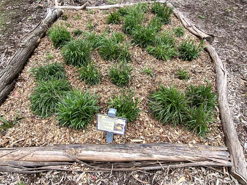
Beside Mount Leura Road on the way to the summit is the Volcanic Plains Wildflower Garden which is a native plant display to showcase and educate visitors on the indigenous flora of the regional volcanic plains. The garden features roughly 30 different native plant and wildflower species, complete with educational information labels.
The garden has some unshaded picnic tables and the Volcanic Education Centre (used for meetings, events and school programs).
Review:
There are lots of walking tracks in the area but the highlight is reaching the summit of Mount Sugarloaf. There are two main ways of getting there. You can start at the Volcanic Plains Wildflower Garden and take the uphill 650m long Lower Shelter Trail (named Saddle Trail on some maps) to the junction point with the Panorama Circuit and Mt Sugarloaf Trail. From there take the grassy Mt Sugarloaf Trail up to the summit of Mount Sugarloaf (2km return).
Alternatively drive past the Volcanic Plains Wildflower Garden to the summit of Mount Leura where there is a carpark, information panels and Mount Leura Lookout. From here take the 1.7km Panorama Circuit which descends down a series of steps to the junction point of Panorama Circuit, Mt Sugarloaf Trail and Lower Shelter Trail. From there take the grassy track up to the summit of Mount Sugarloaf (2km return). After returning from Mount Sugarloaf, continue along Panorama Circuit back to the carpark which passes a shelter with information panels, seating and an unshaded table.
There are a number of branches to take depending on how much walking you want to do.
Information Panel at Shelter
Site history
Approximately 25 million years ago this site was on the ocean floor. Shallow, warm ocean waters of the Miocene period (25-5 million years ago) had abundant marine life such as corals, sponges, echinoderms, brachiopods and molluscs. Larger marine species, including fish, sharks and whales were also common. Fossilised sharks’ teeth and shells have been uncovered in the local area.
Approximately 2-4 million years ago, lava flows covered much of south-western Victoria, creating one of the world’s larger volcanic plains. This plain covers an area of 15,000 square kilometres, with an average thickness of 60 metres, and including over 400 volcanoes.
Approximately 1 million-30,000 years ago, megafauna (giant relatives of today’s animals) roamed the volcanic plain. Many fossil remains and trackways (foot prints) have been discovered in nearby locations. We still don’t know why they disappeared! Aboriginal stories about giant beasts may also be grounded in a time when people shared the land with megafauna.
Aboriginal people lived in the area prior to the volcanic eruptions that created numerous volcanic cones and crater lakes. The Leehoorah Gundidj clan (part of the Maar nation) lived at the base of Mt Leura and held inter-tribal meetings on the shores of lakes Gnotuk and Bullen Merri. It is believed other uses of the area included: ceremonial sites; a source of food (hunting and gathering); medicine and materials for tools and weapons (e.g. boomerangs, woomeras, spears, cutting tools, baskets, coolamons, grinding stones, stone axes). The Camperdown Heritage Centre has quite a good display of such items.
Approximately 30,000 years ago… The Mount Leura complex began with a violent explosion that formed a broad, shallow maar crater. This crater is approximately 2.5 km by 1.7 km wide and is ringed by a low rim of tuff (volcanic ash). Over the next months or maybe years, further volcanic activity within the original crater resulted in the formation of over 20 scoria cones, of which Mount Leura and Mount Sugarloaf are the biggest.
These cones would have been created by spectacular fountains of ash and scoria. Volcanic bombs and blocks are thrown out. In geological terms this is a very recent activity and the complex should be seen as a part of a dormant rather than an extinct volcanic landscape.
From 1839 onwards, the first European settlers to settle in the Camperdown district were the Manifold brothers in 1839. By the early 1840s, most of the land in the Western District of Victoria had been taken up. By the early 1900s, the Leura complex was almost completely cleared of its natural vegetation, and since then has mainly been used for grazing and quarrying.
The Mt Leura Reserve was established in 1896 and the Mt Sugarloaf Reserve in 1972. Both have been popular sites for visitors. Since 1991, the management committee has embarked on a large-scale project to remove exotic trees and other weeds, and revegetate with indigenous species.
Photos:
Location
Mount Leura Road, Camperdown 3260 View Map


