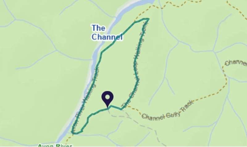
Boisdale - The Channel Loop Walk


This 2.1km loop walk descends into The Channel on Avon River, a magnificent gorge carved out by the river through history.
The steep sides of the gorge are covered in shady casuarinas and other native vegetation. Rugged cliff face meets the riverbed, creating a system of pools and rapids that provide important habitat for aquatic life.
The walk down is steep with several stairs, but the return loop provides a more gradual walk back up to the trail head.
The grade 3 walk has many steps, short steep hills, formed track, some obstacles and limited signage. Bushwalking experience is recommended.
This track is part of the longer Avon River Walking Track, a 10.5 km one way walking track that starts at Huggett's Crossing Picnic Area and ends near Dermody's Camp.
How to get there
From Maffra take the Maffra-Briagolong Road out of Maffra towards Boisdale. Continue through Boisdale towards Valencia Creek. Turn Left onto Luckman's Road (3km beyond Boisdale) and finally right into Warrigal-Toms Creek Road. From here turn left onto Green Hills Road and then right onto Channel Track. Please note, the nearby Channel Road does not access the Channels carpark. Access is 4WD.
The co-ordinates of the start point of the walk are: -37.810406,146.875633
Access for Dogs:
Dogs allowed
Location
Channel W Road, Boisdale 3860 View Map
Web Links
→ www.exploreoutdoors.vic.gov.au/activities/walking-in-victoria/the-channel-loop


")