Blakeville - Werribee River Walk


Enjoy the peaceful sights and sounds of the Werribee River along this 4.5 km walk.
Nestled in a quiet forest valley is the Werribee River Picnic Area, where two unshaded picnic tables and wood-fired barbeques are available. Camping is not permitted here.
This site features excellent access for 2WD vehicles. Turning off the Ballan-Daylesford Road you'll find a well-formed forest track. On the journey into the site, you can enjoy the beautiful native forest that the track winds through.
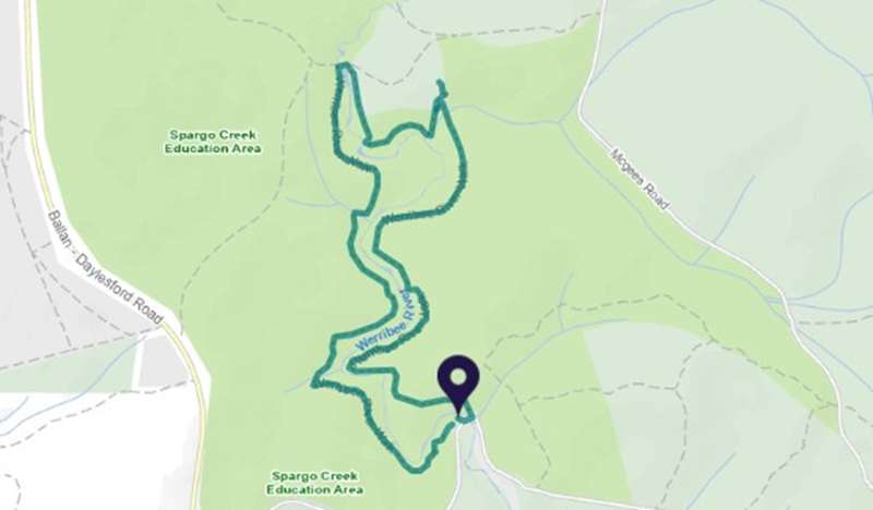
After a break at the picnic area, you can venture out along the Werribee River Walk. Starting at the south-western side of the picnic area, the 4.5 km circuit walk follows the river to Carrolls Spring and then returns back to the picnic area.
Wander through the forest and take in gorgeous views of the river beneath you and the sounds of the forest. The trickle of the river, local birdlife chirping and the occasional thump from a retreating wallaby add to the peaceful ambiance of this site.
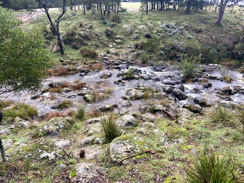
In the wetter months, the river rises to its highest point. During this time walkers may get their feet wet crossing the river.
For visitors looking to spend longer in the area, there's plenty of space for camping at Carrolls Spring located at the north end of the walk.
The walk has occasional steps, short steep hills, formed track, some obstacles and is sign posted. Bushwalking experience recommended.
How to get there
The Werribee River Picnic Area is located approximately 1 hour from Melbourne taking the Western Highway toward Ballarat. At Ballan follow the signs to Daylesford and turn right into Bunding-Blakeville Rd at about the 9.5 km mark. The picnic ground is approximately 1.2 km east. From Daylesford head south toward Ballan on the Daylesford - Ballan Rd for approximately 20.5km, then turn left down Bunding-Blakeville Rd for 1.2km to the picnic area. Suitable for 2WD vehicles.
The co-ordinates of the start point of the walk are: -37.879808,145.1261952
Access for Dogs:
Dogs allowed
Carrolls Spring
The walk can also be started at Carrolls Spring which has a spacious picnic site which features its own mineral spring. This site has no toilet facilities. To get there, head south out of Daylesford on the Ballan-Daylesford Road for approximately 16km to Spargo Creek, then left down the Spargo-Blakeville Road for 1.4km. Turn right down McGees Road for 2.6km, then right down Carrolls Track and continue on for 0.6km to the site. The track can be accessed in the south-east corner of the camping area.
Review:
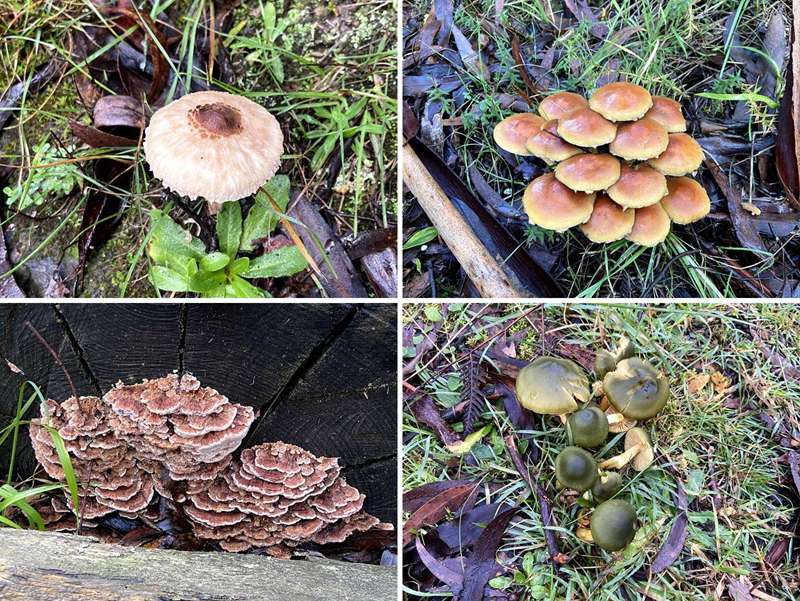
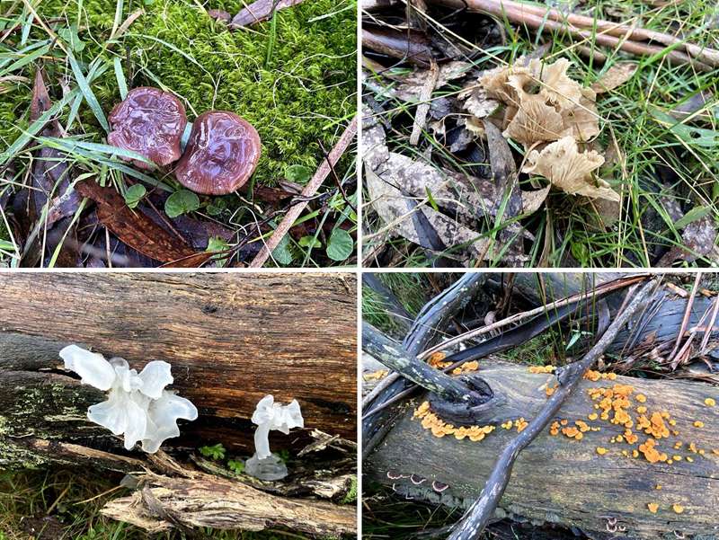
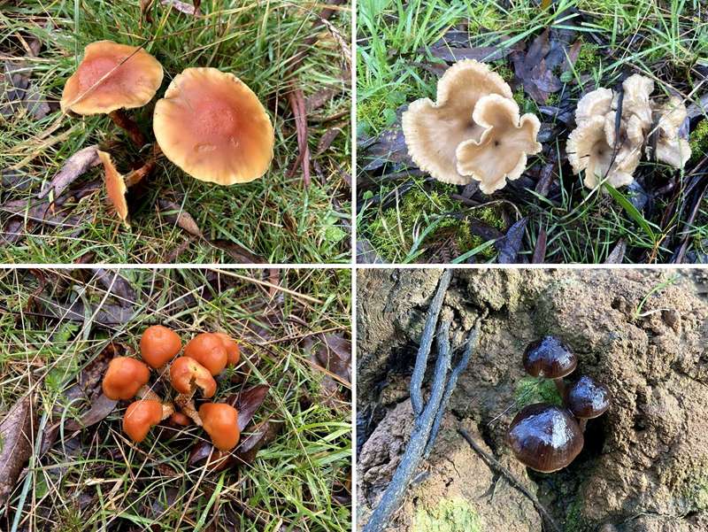
Highlights of this walk include following a section of the Werribee River, crossing the river to get from the west to east bank and a proliferation of beautiful fungi during the cooler months.
We did the walk in June and the array of different fungi was amazing. Take your time and check out all the fallen trees with mosses and fungi.
The track is a bit unloved and quite overgrown with bracken and bushes in some sections. We wouldn't be very comfortable doing the walk during the summer months because it wouldn't be easy to see snakes. There was some signage but it was very sparse.
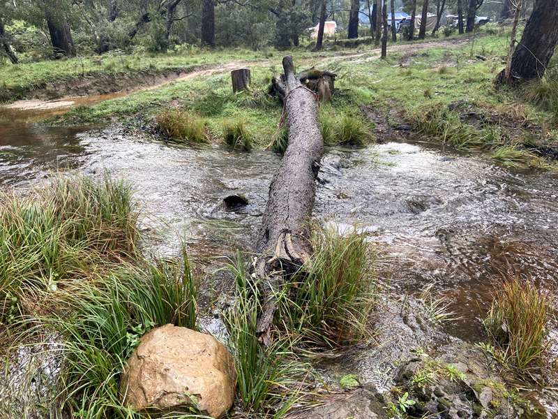
At the half way point, the site of the Werribee River Camping Ground (also called Carrolls Spring Camping Area), you need to find a way to cross the river. If the water level is low, you can rock hop across but higher levels may necessitate getting your feet wet. When we did the walk, there has been quite a lot of rain in the previous days and the river was raging a bit. However, in this area, we found a fallen tree which stretched across the river and walked across it to the other side. The skill level requirement to walk across the "log bridge" was not too difficult and no-one fell into the water.
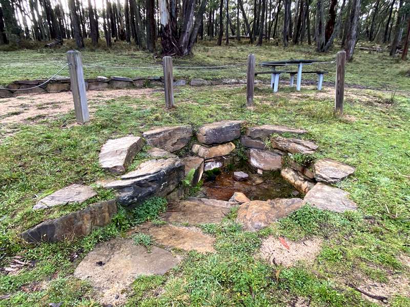
The track then skirts around the western and southern sides of the cleared camping ground. When you get to the south east corner, there is a short diversion to the Carrolls Mineral Spring which has an unshaded table and a water pipe which barely dripped with water. There are no other facilities such as toilets.
After returning from the mineral spring, head south across a bridge and follow the trail which joins the river and runs beside it. At a point towards the end of the walk the trail heads uphill and cuts across the top of the hill before steps lead down to the starting point picnic ground. The trail was a bit indistinct and we followed close to the river too far and had to bush bash (not too difficult) up the hill to find the track. I think this was the section where we picked up a couple of leeches. Google maps was a friend here because we had some phone reception.
Photos:
Location
Bunding-Blakeville Road, Blakeville 3342 View Map
Web Links
→ www.exploreoutdoors.vic.gov.au/activities/walking-in-victoria/werribee-river-walk
→ www.exploreoutdoors.vic.gov.au/activities/picnicking/carrolls-spring


")