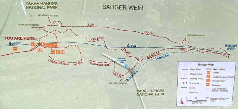
Badger Creek Weir Picnic Area and Walks


A favourite picnic spot in the Yarra Valley is Badger Weir Picnic Grounds, located at the end of Badger Weir Road, off Don Road in Healesville/Badger Creek, 7km from Healesville.
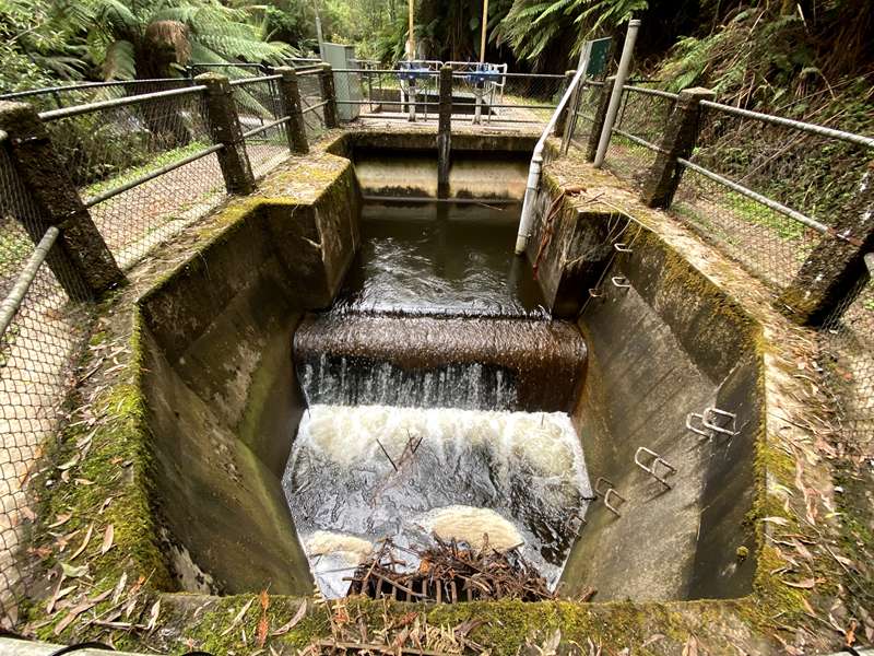
Old-style shingle roof rotundas, landscaped grounds and barbeques, surrounded by the beautiful Mountain Ash trees of the Yarra Ranges National Park, this is the perfect spot to picnic with family and friends, whilst watching the local resident birdlife including the Australian King Parrot, Crimson Rosella and the Superb Lyrebird. The weir itself was constructed in 1909, and is a water catchment area for Melbourne.
Enjoy a short walk around the Badger Weir. There are three family-friendly nature walks leading from the picnic grounds to Badger Creek Weir:
- Badger Weir via Slip Creek Track (1.4km, approx 30 minutes, Moderate) - Due to steps, not suitable for prams and strollers
- Badger Weir via Coranderrk Track (1.2km, approx 30 minutes, Easy) - Follows vehicle track to weir
- Badger Weir via Lyrebird Track (1.2km, approx 30 minutes, Easy) - A few steps
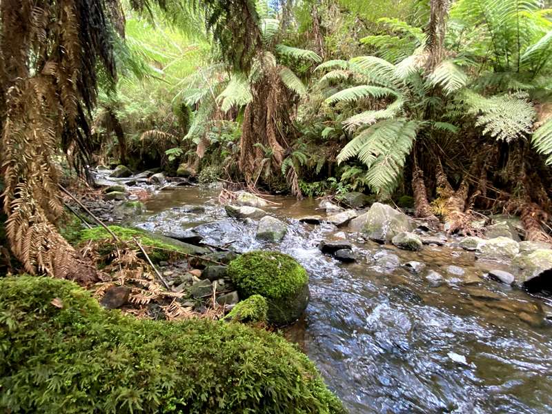
Badger Weir is a special spot year round with magnificent fungi appearing in autumn and winter, and the creek offers a perfect place to dip your feet and cool off in summer.
Access for Dogs:
Dogs are not permitted.
Opening Hours:
8am to 8pm - Early October to Early April (Start of Daylight Savings Time to End of Daylight Savings Time)
8am to 6pm - Early April (End of Daylight Savings Time) to end of April
8am to 5pm - May to August
8am to 6pm - September to Early October (Start of Daylight Savings Time)
These times apply to Maroondah Reservoir Park, Badger Weir and Donnellys Weir.
These parks and visitor sites are protected for water security purposes by automatic gates. The gates close at the above posted times, but they do allow for visitors to leave the park for 30 minutes after these times. From 30 minutes after the posted closing time however the after hours exit turns off and exit from the park is no longer possible. Parks Victoria is obliged to do this to help strengthen water resource security.
If a visitor mistakenly gets caught behind the automatic gates after the park closing time, upon exit please drive to within two metres of the gate to activate the late exit trigger. If the gate does not open as the vehicle is leaving too late, please call Parks Victoria on 13 19 63 to ask them to assist. A late exit fee may apply.
Review:
A wonderful picnic location location beside Badger Creek with lots of picnic tables, two pavilions with tables, BBQs and toilets.
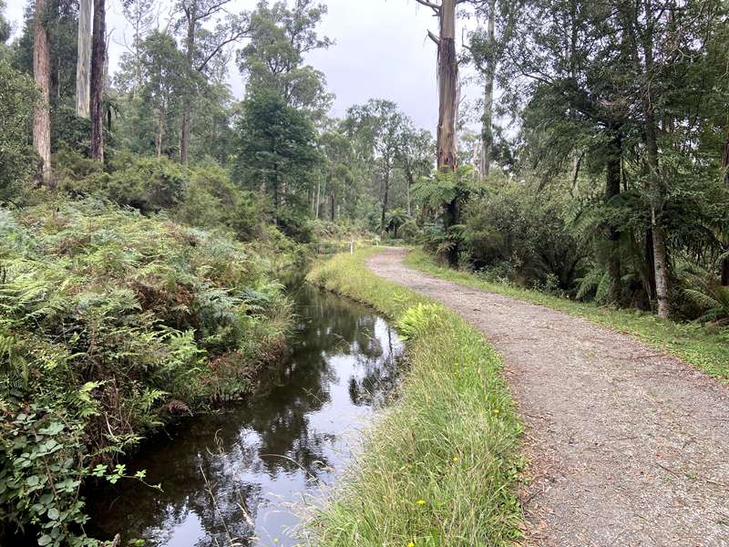
There are three wonderful short walks to Badger Weir. The easiest walk is Coranderrk Track which is a flat, vehicle track. Part of the track is beside the Coranderrk Aqueduct which takes water to Silvan Reservoir.
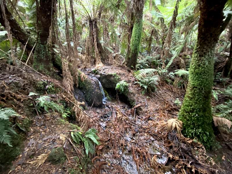
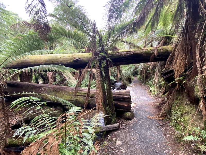
By far the best walk is Slip Track which is more up and down and passes through an area of beautiful rainforest with boardwalks and steps. This track is the most wild and had a number of trees which had fallen across the path. It can also be a little muddy near the creek.
The middle level walk is Lyrebird Track which passes through a nice area of tree ferns and did have evidence of lyrebirds scratching about in the ground although we never actually saw one.
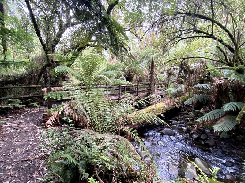
Slip Track and Lyrebird Track walks start at the same point from the picnic ground - at a bridge across the creek and split after 100m. Coranderrk Track starts at the far end of the picnic grounds.
We would suggest walking to the weir via Slip Track and returning via Lyrebird Track.
There are gates at the entrance to the picnic area which automatically close at a designated time (which is shown on signage). Late exit fees may apply so keep track of time towards the end of the day.
Information Panels:
There are a number of information panels at the picnic ground.
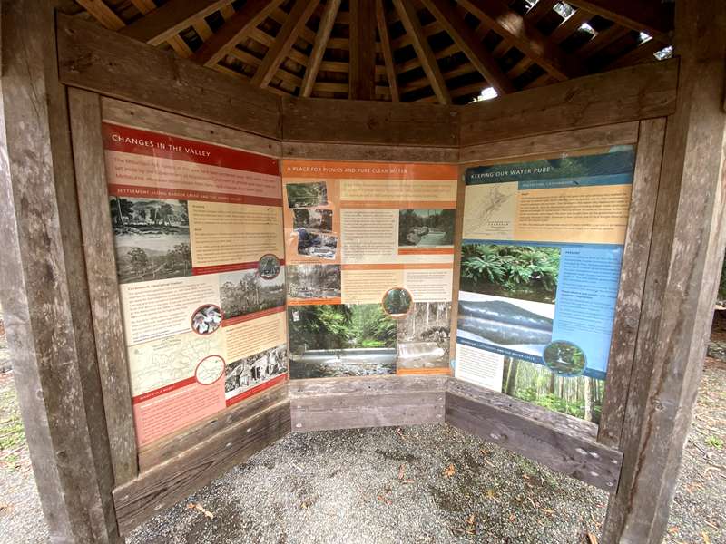
CHANGES IN THE VALLEY
The Mountain Ash forests of this area have been protected since 1872 when they were set aside by the Government as Maroondah Catchment to provide pure clean water for Melbourne. However downstream from here rapid changes have taken place.
SETTLEMENT ALONG BADGER CREEK AND THE YARRA VALLEY
Grazing
The earliest European settlers in the Yarra Valley were the Ryrie brothers who set out from NSW with their large herd of cattle. They arrived in 1837 and settled on the Myer flats at Yering near the present day town of Yarra Glen. Their run reached as far as Badger Creek, which it is believed was named after one of their horses who became bogged in the creek.
Gold
The rapid increase in Victoria's population in the 1850s due to gold discoveries to the north-west of Melbourne increased the demand for meat and more and more farmland was opened up in the Yarra Valley.
In the 1860s gold was discovered in the ranges to the north east of Melbourne. Roads were opened through the mountains to the goldfields at Woods Point and the Upper Yarra. Healesville and district was inundated with people wanting to get to the goldfields. The growing town of Healesville was officially surveyed in 1864, followed by the first land sales held in 1865.
Coranderrk Aboriginal Station
The government gazetted 2300 acres (920 hectares) as 'Land reserved for Aboriginal Purposes' on 30th June 1863. This land was set aside for the indigenous people in compensation for what they had lost and they named it Coranderrk after the flowering Christmas bush that grows in the area. It was one of the most successful farms in the district from the 1860s to 1880s winning several agricultural awards for its high quality hops.
By the early 1890s disease, bureaucratic intervention and neglect had undermined the successful settlement at Coranderrk and in 1924 Coranderrk was closed.
Badger Creek Village
Badger Creek was part of the village settlement scheme. In 1893 unemployment in Melbourne was very high and the government began to set up village settlements outside Melbourne to ease the situation In 1893, 650 acres (260 hectares) of Coranderrk Aboriginal Station was excised for the site of a settlement. Lot sizes of 18 acres (7.2 hectares) were made available for settlement. The new settlers were required to 'improve the land' to obtain freehold title. 'Improvements' such as tree clearing and fencing were given a monetary value.
WHAT'S IN A NAME?
Badger Creek or Coranderrk Creek?
Badger Creek ran through Coranderrk Station, which was downstream from the present day Badger Weir Picnic Area.
The name Badger Creek first appeared in 1850 on early maps of the area. From 1864 onwards maps and photographs called it Coranderrk or Badger Creek or both. Up to the early 1990s Badger Weir was still named Coranderrk Weir. Today Badger is the official name of the creek and weir as it was the name first published and most widely used today.
A PLACE FOR PICNICS AND PURE CLEAN WATER
By the 1880s Healesville was becoming a holiday town for city people wanting to escape to the fresh healthy mountain air. Many guest houses were built and the railway arrived in 1889 bringing more holiday makers to the area.
WATER FOR A GROWING CITY
In the late 1870s Melbourne needed more clean water. The Yan Yean system, completed in 1857, could not supply enough clean water to the growing city. The government began to build the Maroondah Water Supply System in 1886. A system of weirs and aqueducts was constructed to send water to Preston reservoir to augment the Yan Yean supply.
The completed Maroondah System harvests water from four streams - the Watts River, Donnelly's Creek, the Grace Burn and Badger Creek which all eventually flow into the Yarra River.
In 1891 the first weir in the Maroondah system, on the Watts River, was formally opened. This was a great event and a public holiday was declared in Healesville. This weir captured the water of Watts River for Melbourne until 1927 when Maroondah Dam was completed leaving the original weir under water.
BADGER WEIR
In 1908 the first weir on the Badger Creek was built with the harvested water being fed by pipes to Maroondah Reservoir.
The original weir was replaced in 1929 by the weir you see today. This weir is 400 metres further upstream than the original weir. It supplies water directly to Silvan Reservoir (110 megalitres of water daily via aqueduct and pipeline) and to Healesville via Frogley Storage Basin. This water storage tank, on Aqueduct Track, holds 4.5 megalittes of water.
PICNIC BY THE WATER
Soon after the original weir was built, Badger Weir Picnic Area was developed This enabled people to view the amazing engineering skills used in harvesting the water.
Exotic trees such as pines and willows were planted to make the picnic area resemble a botanical garden These exotic trees remind us today of the attitudes to the Australian bush early last century.
PROTECTING CATCHMENTS
PAST The Victorian government of the 1870s had some very wise advisors who realised the only way to prevent water borne diseases, such as typhoid, was to close catchments human habitation and activities. Their foresight is the reason why Melbourne's water is so pure today. By 1872 the Maroondah catchment (including Badger Creek catchment) was recommended for conservation. Plans to remove the town of Fernshaw, in the middle of the catchment, were begun. The town was bought back by the government and eventually removed in 1890 (Fernshaw is now a picnic area in Yarra Ranges National Park and can be enjoyed by all).
In 1891, The Melbourne Metropolitan Board of Works (MMBW, now known as Melbourne Water) was formed to manage Melbourne's water supply and sewerage sytems.
PRESENT Some 64 500ha or 84% of Yarra Ranges National Park is water catchment and is jointly managed by Parks Victoria and Melbourne Water (both Victorian government agencies). This joint management area is known as the Designated Water Supply Catchment Area (DWSCA). This area supplies approximately 50% of Melbourne's water. To maintain high standards of water quality public access is not allowed in the DWSCA.
FLORA OF NATIONAL SIGNIFICANCE
Badger Weir's magnificent old growth Mountain Ash and Manna Gum forests main largely undisturbed, providing home and shelter for a rich diversity of native birds and animals.
The old growth forests were protected from commercial logging when the area was set aside for water catchment in 1872, and they are now considered to be of national significance.
TALL TREES
Mountain Ash trees range in height from 30 to 100 meters and are the tallest species of hardwood in the world.
The picnic areas were established in the early 1900s when exotic species such as Deodar Cedars, Douglas Firs and Coastal Redwoods were planted. Such exotic plantings now provide an insight into the prevailing attitudes of the era when "improving" an area meant re-creating a European landscape.
In 1939 severe bushfires affected the areas surrounding Badger Weir. In some areas mature forests were destroyed and current vegetation can be dated back to the event, while in other areas patches of untouched older vegetation remains.
A HAVEN FOR SOFT TREE FERNS
Along the creek and gullies soft tree ferns thrive in the rich, deep and damp soils under a canopy of Musk Daisy Bush, Hazel Pomaderris and Silver Wattle. These species are typical of Victoria's Eastern Ranges including the Dandenong Ranges and the Great Dividing Range.
Tree ferns grow incredibly slowly, at a rate of only 2cm per year This means the large ones you see around you are over 200 years old!
FAUNA
What animals live here? (The word animal includes birds, insects, animals and reptiles)
Habitat (homes for animals)
Badger Weil is a special place where the forest wilderness surrounds a small cleared picnic area. Visitors are able to see forests that have never been logged. The surrounding mountains have been closed to people since the 1890s when they were made a dosed catchment. This was done to keep Melbourne's water supply clean.
Look around you and you will see many hollows in the old trees. Many native animals nest in hollows. This is why you see so many birds here. Crimson Rosellas, King Parrots, Sulphur Crested Cockatoos and Kookaburras all nest in hollows in trees.
Most people from Melbourne are familiar with the native possums that live in the city - the Common Brushtail Possum and the Ringtail Possum. Out here in the old growth forest we have Gliders and Mountain Brushtails as well.
At night the forest comes alive with mammals that nest in the old hollows. If you come on a guided night walk some of the animals you may see are the Greater Gliders, Yellow Bellied Gliders and Powerful Owls. These mysterious animals are only found in old growth forests.
Superb Lyrebirds
Superb Lyrebirds are common at Badger Weir. Their diggings are often seen in the lawns of the picnic area. Take a walk along any of the walking tracks and you will probably see or hear one. Lyrebirds are wonderful mimics and can copy the call of rosellas, Kookaburras, Whipbirds and Yellow-tailed Black Cockatoo (and many other calls and sounds).
Photos:
Location
Badger Weir Road, Badger Creek 3777 View Map
Web Links
→ www.parks.vic.gov.au/places-to-see/sites/badger-weir-picnic-area
→ Badger Weir via Coranderrk Track (Walking Maps)
→ Yarra Ranges National Park Healesville Area (Park Notes)


")