Yalukut Willam Walk (St Kilda West)

The Yalukit Willam trail celebrates the Indigenous custodians of the Boon Wurrung language group, who for 40,000 years or more occupied the landscape we now call the City of Port Phillip.
Walk Start and Finish: West Beach Natural History Reserve, corner of Pier Road and Beaconsfield Parade, St Kilda
Length: Four kilometres
Time: 60 - 90 minutes
Note: There are multiple spellings of 'Yalukut Willam' and 'Wominjeka' due to the contemporary evolution and revitalisation of the Boon Wurrung language.
Further information on walks and history can be found in the Yalukit Weelams booklet.
Yalukit Wiliam descendants, historical records of camping places, ceremonial sites, creation stories and burial places testify to the First Peoples occupation. Point Ormond hill in Elwood was the site of an Aboriginal midden and no doubt served as a strategic lookout. The large number of wetlands such as those at Lagoon Oval (Port Melbourne), Elster Creek (Elwood Canal) and Albert Park Lake provided a rich abundance of food.
A ngargee is a cultural and social gathering, sometimes referred to as a corroboree. These took place at sites including Emerald Hill, today the location of the South Melbourne Town Hall. The Ngargee Tree - an ancient ceremonial red gum - is the City's oldest living entity and overlooks what is now St Kilda Junction.
The St Kilda area was recorded as Euro-Yroke or the 'grinding stone' area that was originally formed of deep red cliffs along the bay shoreline. Grinding stones were used to sharpen stone axes, an essential tool of all adult males.
This trail includes a wetland, billabong, traditional camping place, a ceremonial tree, a memorial garden and a possum colony.
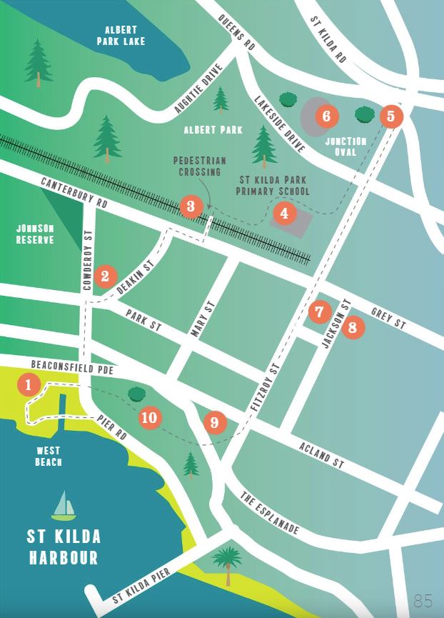
Trail Key:
1 West Beach Natural History Reserve
2 Deakin Street
3 Albert Park
4 St Kilda Park Primary School
5 Ngargee (Corroboree) Tree
6 Junction Oval
7 Jackson Street
8 Wattle House
9 Cleve Gardens
10 Catani Gardens
Map of Route:
As it was once was
Start the walk at the West Beach Natural History Reserve (1) on the corner of Pier Road and Beaconsfield Parade. The Federation bench, made from ancient trees, celebrates the rich Yalukit Wiliam history of Port Phillip where camping places, ceremonial sites and creation epics testify to the millennia of First People's occupation. The park is a re-creation of a typical saltmarsh landscape before European settlement. Cross the footbridge over Cowderoy Canal and explore the paths. Here can be found Indigenous plants used by the Yalukit Wiliam. Common 'pigface' has an edible berry, its juices are used as a painkiller for stings and it can be squeezed to provide water for drinking. Indigenous grasses were used to weave baskets, nets and ornaments.
Relax on one of the benches, one of the finest locations in Port Phillip to enjoy a sunset over Hobsons Bay. Yalukit Wiliam clan and people of the Boon Wurrung language group recalled Hobsons Bay as a 'kangaroo ground' before the sea broke through the Heads at the end of the last Ice Age up to 9,000 years ago. An early creation story tells how Bunjil, the ancestral creator, placed rocks in this part of the Bay to stop the approach of the sea during the great flood.
The Yalukit Wiliam Federation bench is located on the footpath at Beaconsfield Parade. Cross over Beaconsfield Parade with the pedestrian lights and proceed east up Cowderoy Street.
More than one Federation
Walk east along Cowderoy Street and turn right into Deakin Street (2) at shady Jacoby Reserve. Alfred Deakin was a prime mover of Australian Federation. He served three terms as Prime Minister and is buried in St Kilda Cemetery. Less well known is his role in implementing racial policies such as the Victorian Half-Caste Act in 1886 and the White Australia Policy in 1901.
Prior to Melbourne's settlement, the area was occupied by an earlier federation of five language groups referred to as the Kulin people each of whom occupied clan estates they regarded as their own since the time of creation. In the 1840s George Robinson, the Aboriginal Chief Protector, recorded that the Yalukit Wiliam clan of the Boon Wurrung language group occupied the St Kilda area also known as Euro-Yroke. The City of Port Phillip, and in particular St Kilda today is a significant gathering place for Aboriginal and Torres Strait Islander people from all parts of Australia. The area is serviced by a range of community and cultural organisations such as the Boon Wurrung Foundation, Ngwala Willumbong and Inner South Community Health Service (Our Rainbow Place).
Turn right when you reach Canterbury Road and cross at the pedestrian lights near Mary Street. An underpass under the light rail line takes you into Albert Park.
Hunting and gathering by the lake
Albert Park(3) is Victoria's most visited park occupying 225 hectares and includes Albert Park Lake. The lake, once a natural lagoon, is circled by five kilometres of walking track. Before settlement the park was an important wilum or camping place for the Yalukit Wiliam and guests to country. They were recorded hunting and gathering and building bark shelters beside the lagoon which teemed with gunabi (ducks) and gunuwarra (swans). The lagoon also provided plants with roots from which starch was extracted to make damper. Wildlife such as tortoises, eels, frogs, fish, and freshwater shellfish would have been harvested. The rich environment meant four or five hours of foraging each day was probably sufficient to meet family needs.
Kids business
From the underpass, St Kilda Park Primary School (4) built in 1880 is on the rise to your immediate right. Take the right hand paths that lead you up to and around the school buildings (towards Fitzroy Street). Children from this school were involved in the development of this Aboriginal trail including planting indigenous flora.
A living monument
Continue past the school following walking paths in the park parallel to Fitzroy Street until you reach St Kilda Junction. For safety, use the pedestrian lights at Lakeside Drive. The St Kilda Ngargee tree (5) is a red gum eucalyptus beside the kerb of Queens Road, 100 metres from its junction with Fitzroy Street. This gum tree, more than four hundred years old, is on the site where Yalukit Willam ceremonies occurred prior to European settlement in 1835 and later as a fringe camp by surviving Aboriginal people. It is a rare and living witness of the change from a hunter gatherer lifestyle to an urbanised society. The tree is listed on the National Trust Register. Note the memorial plaque near the base of the tree.
Yalukit Wiliam dance ceremonies such as ngargee and gaggip celebrated important events and meetings and promoted unity between communities. Dances were also used to tell traditional stories. The men often decorated their bodies with designs in white clay and coloured ochre. The women chanted and drummed on skins stretched tightly between their legs, clapped their hands and beat sticks and boomerangs together to provide the rhythm of the dance.
Cockatoos, galahs and possums still meet at the tree. Black ducks frequent the billabong. Sometimes a stick nest of Waa the crow, one of the two moieties of the Kulin nation, has been seen in the upper branches.
Many people see the protection of this living monument as an important contribution not only to reconciliation but to reciprocity and genuine acts of equal exchange. Local residents have created the native grasslands, billabong and a ceremonial circle in the vicinity to commemorate Aboriginal occupation and promote the health of this elder red gum. Retrace your steps past Junction Oval towards St Kilda Primary School and then walk down Fitzroy Street.
Marngrook
Note Junction Oval (6) on your right as you return towards the school. This historic oval was the home ground of the St Kilda Football Club until the Saints moved to Moorabbin. James Wandin, a descendent of Barak, played at the ground for St Kilda in the 1950s.
The club was founded in 1873. Both Aboriginal men and women played forms of football prior to settlement. In 1839 Assistant Protector William Thomas recorded an Aboriginal game called marngrook in which a rolled ball of possum skin bound tightly with kangaroo sinew was kicked high in the air by two teams:
There is general excitement who shall catch it, the tall fellows stand the best chance, when the ball is caught it is kicked into the air with great force...they will play at this game for hours and fine exercise it is for adults and youths.
Seizing the land
Continue down the north side of Fitzroy Street until it meets Jackson Street (7) on its south side. Samuel Jackson was a member of John Fawkner's syndicate. Aboriginal people had land ownership of Melbourne for up to 50,000 years or more before two rival Tasmanian syndicates led by Fawkner and Batman claimed ownership in 1835. Only fifteen years later, Samuel Jackson erected his prefabricated Wattle House at 53 Jackson Street (8). Proceed down Jackson Street and continue left toward Grey Street to visit St Kilda's oldest home.
The occupying settlers built many colonial mansions on former Aboriginal lands in what is now called Fitzroy Street. Many shops are located in their former front gardens such as 83-97 Fitzroy Street. Glance between 91 and 97 to glimpse Brooklawn mansion.
A modern meeting place
Cleve Gardens (9) designed by Sali Cleve in 1911, is located on the triangular reserve at the corner of Fitzroy Street and Beaconsfield Parade. Aboriginal people, including arrivals from interstate, used this reserve as a meeting place for many decades despite attempts to discourage their presence. Local by-laws were often used to restrict public meeting places in areas like Fitzroy. Residents remember Cleve Gardens as a gathering place for the 'parkies' and the well-known designs painted on the former ablution block: the Aboriginal flag, giant lizards and Uluru.
Media attention was focused on the site in 1996, when this block was bulldozed to 'clean up' the area for the Grand Prix. Native plants, heritage markers and wave-shaped seating have been constructed since in consultation with community members. The site is included on Aboriginal Affairs Victoria's Historic Sites Register. Note the memorial to Robbie Hunter, 'Chief, from the 'parkies'.
A home for marsupial Australians
Cross Beaconsfield Parade to the Catani Gardens (10) on the foreshore. A night visitor to these gardens will often encounter semi-tame walert (brush-tail possum) which descend from the trees in search of food. Walert were an essential source of food and clothing for Aboriginal people. Walert-gurn or possum skin rugs were made of up to 80 skins that, despite their extraordinary lightness, were warm and waterproof. The skins were stretched and sewn finely together using sinew and needles made of pierced animal bones. The inner skin of the cloak was scored with shells to create striking designs and to make the skin supple.
Near St Kilda Pier is a 1914 sculpture of Captain James Cook who claimed eastern Australia for the British in 1770 ignoring its occupation by hundreds of indigenous nations and tribes.
Return to your starting point at West Beach by walking north along the paths in Catani gardens.
Location
330 Beaconsfield Parade, St Kilda West 3182 View Map


")