Yalukut Willam Signs (St Kilda West)

The City of Port Phillip has unveiled a series of Aboriginal interpretative signs to recognise and celebrate the continuing culture of the local Boon Wurrung people as part of its Reconciliation Action Plan. The signage was launched in 2016 during Reconciliation Week.
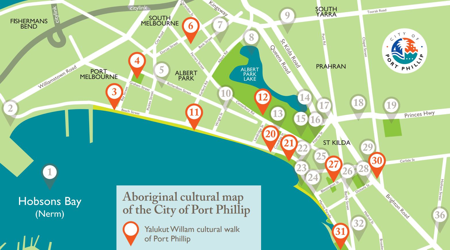
The 10 signs, which form a self-guided tour of Port Phillip, were created with the Boon Wurrung Foundation and include information about significant Aboriginal landmarks and historical figures.
The signs stand at 1.6 metres tall and feature contributions from Boon Wurrung artist Jarra Steel. They have been installed at Point Ormond, Beaconsfield Parade, Peanut Farm Reserve, St Kilda foreshore, West Beach, South Melbourne Market, Fraser St, Lagoon Reserve and Port Melbourne foreshore.
Note: There are multiple spellings of 'Yalukut Willam' and 'Wominjeka' due to the contemporary evolution and revitalisation of the Boon Wurrung language.
Further information on the signage, walks and history can be found in the Yalukit Weelams booklet.
Map of Indigenous landmarks
Points marked with an orange marker indicate the 10 signed Indigenous landmarks across Port Phillip, and those marked with a grey marker are other Historical Aboriginal cultural sites.
Sign Location One - Point Ormond (#31 on map)
Sign situated between bike path and walkway in front of Point Ormond Beacon Hill.
Boon Wurrung People around this area cooked shellfish (shell middens in close proximity) and controlled back burning of land.
Today's hill is remnant of the former 'Little Red Bluff' which was a lookout, camping area and a source of ochre, an earthy pigment used in ceremony. a shellfish midden was uncovered in about 1974. Stone axes and bone awls have also been found at the Point. the adjacent reef was an important source of food. In April 1840 Aboriginal women were collecting shellfish three times a week were they were banned by the government.
Sign Location Two - St Kilda Town Hall (#30 on map)
Sign situated next to pathway leading to St Kilda Town Hall front entrance on Carlisle Street.
The impact of Clan (Arweet) leader Derrimut on the early Melbourne colony is remembered at this site.
The Boon Wurrung frequently camped, after settlement, on the triangle of land that now includes St Kilda Town Hall, St Kilda Primary School, Bubup Nairm and other community centres.
Sign Location Three - Peanut Farm Site (#27 on map)
Sign situated on footpath leading towards mural by street artist Adnate, and featuring two local Aboriginal residents off Spencer Street.
The Peanut Farm Reserve is a registered Yalukut Willam tool site and the centre of a growing Aboriginal precinct in the City of Port Phillip.
The Pavilion with its striking mural is a venue for regular Indigenous sporting events. Veg Out Community Garden hosts the Wominjeka gathering place and events such as Mabo Day, Sorry Day and NAIDOC.
Nearby O'Donnell Gardens is a gathering site and a venue for the annual Yalukit Willam Ngargee Festival.
Our Rainbow Place is a popular gathering venue at Inner South Community Health Service in nearby Mitford Street.
Sign Location Four - St Kilda Pier (#21 on map)
Sign situated near junction of Pier Road leading onto St Kilda Pier and front shore walkway
Louisa Briggs was born in 1835 and died in 1925. As a young girl, Louisa, and her family were kidnapped by sealers and taken to the Bass Strait to work as slaves. In 1848, Louisa returned to Boon Wurrung country with her Aunt and her husband, John Briggs.
Louisa was an activist and her descendants continue to make a significant contribution to Victorian culture.
St Kilda was known to the Yalukut Willam as Euro-Yroke or the grinding stone place where they sharpened their stone axes. These axes sharpened on St Kilda foreshore, were an essential tool used by Yalukut Willam men for cutting bark from trees for housing, canoes, shields and containers. Two such axes were excavated at Elwood in 1974.
Sign Location Five - West Beach (#20 on map)
Sign situated on pathway junction leading over bridge towards Pier Road.
The Boon Wurrung clans travelled annually along the foreshore to the Mornington Peninsula and inland to the Dandenong foothills before returning to the bay in warm weather.
Coastal salt marshes like West Beach were a source of tools, medicine and food. Possums or 'walert', such as found today in Catani Gardens, were a favourite source of food and clothing.
Sign Location Six - South Melbourne Market (#6 on map)
Sign situated on the corner of Cecil Street and Coventry Street in South Melbourne.
South Melbourne, including today's market area, was known to the Yalukit Willam clan as Nerre nerre minum. Ngargee (corroborees) were held regularly on the full moon on Emerald Hill, today the site of South Melbourne Town Hall.
The clans camped and built bark shelters around Albert Park Lake and harvested fish, tubers and bird life. Just north of today's market was the former waterfall on the Birrarung (Yarra River) which was a source of fresh water, a crossing point and a central meeting place for clans of the Kulin Nation.
Sign Location Seven - Port Melbourne Lagoon Reserve (#4 on map)
Sign situated on Lagoon Reserve pathway (Esplanade West) and Bubup Womindjeka Family and Children's Centre.
The Boon Wurrung define the year by six distinct seasons. Each season is based upon the stars and the moon and reflected by the plants that grow and the behaviour of the animals, birds and insects.
Wygabil-ny-ewin or Old Man Sun, is late summer, the rains arrive and the Boon Wurrung traditionally commenced their fire-stick farming, directed by Elders, preparing the land for regrowth.
True spring or Pareip, is from September to October. It recognises the closeness of the constellation of Turt-Bul Liwurruk or the Seven Sisters. At this a large Ngargee or ceremony was held and visitors arrived from the other clans of the Kulin Nation.
Sign Location Eight - Bay Street, Port Melbourne (#3 on map)
Sign situated at the junction of Bay Street and Beach Street, opposite the Pier Hotel.
The Yalukut Willam clan of the Boon Wurrung used firestick farming to manage and encourage the growth of the myrrnong, a starchy plant that was widely cultivated, making it an important part of their diet.
The Port Melbourne area also contained wetlands, rich hunting grounds for game, fish, eels and tubers.
Sign Location Nine - Albert Park Yacht and Angling Club (#11 on map)
Sign situated on Bayside bike trail, opposite the Albert Park Yacht and Angling Club.
The law and custom of the Boon Wurrung required all visiting clans to observe respect for their language and culture. Loo-ern is a spirit being and lives in the mountain called Warnoon, also known as Wilsons Promontory.
Sign Location Ten - Fraser Street (#12 on map)
Sign situated at entrance way to Fraser Street tram stop on Canterbury Road.
William Thomas was appointed Assistant Protector of Aborigines in 1838. Thomas understood and respected the structure and hierarchy of traditional Yalukut Willam society.
His strong religious convictions and deep spiritual beliefs resonated with the Yalukut Willam. In recognition of his commitment towards the traditional owners, he was given the title Marminata, which translated in Boon Wurrung means 'the good father'.
Location
330 Beaconsfield Parade, St Kilda West 3182 Map
Web Links
→ Yalukut Willam map (PDF)
→ Yalukut Willam Signs
")


")