Woodend - Five Mile Creek Walk


Whether you are going for a pleasant stroll or a vigorous walk, the Five Mile Creek Track offers an interesting course through areas of unique native vegetation, with adjoining picnic grounds, reserves, and recreational facilities. There are some good spots for birdwatching along the track. The western section leads through a black gum reserve. It is the only place in the state where these trees (Eucalyptus Aggregata), which have become the town's emblem, can be found.
The track commences at the northern end of Jeffreys Street and finishes at Romsey Road, covering a total distance of 3.4 km in one direction.
Note that in following the path over the footbridge behind the Visitor Information Centre you may find the route under the High St Bridge to be inaccessible due to raised creek levels. If this is the case it will be necessary to cross High St (with caution) and return to the track on the East side of the bridge.
Continuing along the way, you will see ample evidence of activity by the Woodend Landcare group in the clearance of noxious weeds, removal or unsuitable vegetation and extensive replanting with native flora.
History of the Five Mile Creek
Collecting water flows from the North Western slopes of Mt. Macedon, the Five Mile Creek becomes one of the tributaries of the Campaspe River, entering the Campaspe at Carlsruhe. Woodend's early name was "Five Mile" due to its situation astride the Creek. This name changed as weary travelers to the goldfields emerged from the boggy tracks and rigors of the Black Forest and heaved a sigh of relief at reaching the "End of the Wood". In early days of development there were Chinese market gardens adjoining the creek in the Woodend area.
Route Map
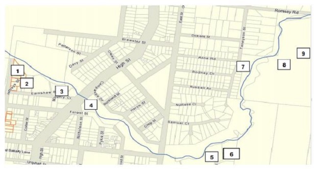
Picnic grounds, reserves & points of interest
1. is the Black Gum Reserve containing specimens of the rare Black Gum (Eucalyptus Aggregatta), which is unique to this area of Victoria. Examples of these flaky barked, graceful trees can also be seen along the Creek, especially near Ruby McKenzie Reserve.
2. indicates the Woodend & District Heritage Society's Memorial Walk commemorating early pioneers, community identities and those who have contributed to the development of Woodend. The bridge carrying High St over the creek was built in 1862 and has since been widened.
3. shows the location of the Lions Reserve with electric barbeque, playground and covered seating.
4. indicates the Woodend Children's Park in a treed setting with outdoor and covered seating, toilets and playground facilities. An adjoining feature is a tennis court for public use and an outdoor gym.
5. shows an area of planting carried out by Woodend Primary School students as a contribution to the re-vegetation project. The area is marked by a plaque adjacent to the track.
6. is similar to above but in this case the planting was done by St. Ambrose Primary School students. This also has an indicating plaque.
7. relates to the Ruby McKenzie reserve with playground and some seating. This reserve is named in honour of a former Councilor in the Shire of Newham & Woodend.
8. reveals a weir across the creek established by Shirley Park Stud to contribute to water supplies for their equestrian activities. In its heyday Shirley Park was a leading thoroughbred horse stud and training facility operated by the Nicholas family. Along the remainder of the track you will notice sections of the old fencing around Shirley Park with an extremely heavy cable along the fence top. This cable came from the old cable tram system in Melbourne at the time of its conversion to electric trams.
9. David Currie Bridge named after a former Woodend resident, who was a keen advocate for a walking trail to Hanging Rock.
Photos:
Location
28 Jeffreys Street, Woodend 3442 Map
Web Links
→ Five Mile Creek Walk Brochure (PDF)
")


")