Wonthaggi - Bass Coast Rail Trail


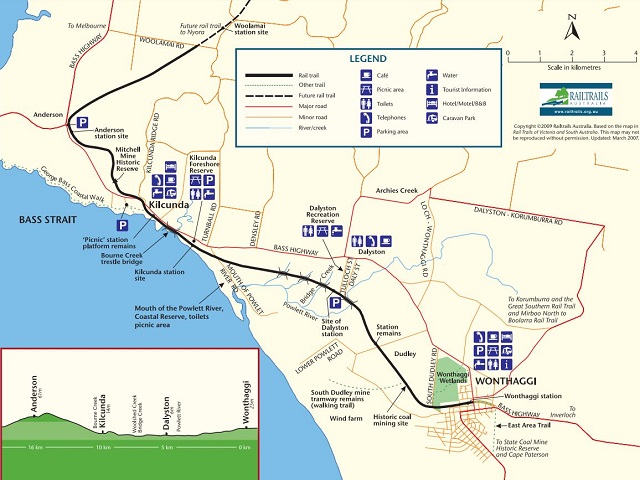
Claiming the title of Victoria's only coastal rail trail, the Bass Coast Rail Trail showcases the region's rich history against stunning backdrops and coastal views. The trail runs through the hinterlands of Wonthaggi, past the sand dunes of Dalyston, across the majestic Kilcunda Trestle Bridge and all the way to the breathtaking ocean views of Woolamai.
A summary of the trail is:
- 23km one way / 6 hours (16km between Anderson and Wonthaggi with optional extension to Woolamai)
- The trail can be done in either direction.
- Start / Finish points are V/Line bus terminal, Anderson and Old Wonthaggi Railway Station, Murray St, Wonthaggi.
- Rating is easy, mostly flat with two moderate climbs (uphill from Wonthaggi)
- Compacted granitic sand, gravel, boardwalk
- Car Parking at Wonthaggi Centennial Centre and Anderson Bus Interchange car parks (sealed)
- Designated Accessible Parking available
- Designated Accessible Toilets at Wonthaggi Centennial Centre, Wonthaggi Guide Park, Kilcunda Foreshore Reserve and Anderson Bus Interchange
- Suitable for wheelchairs, sections closest to Wonthaggi and Kilcunda being the most accessible
- Bicycles permitted
- Dogs permitted on a lead
- Horses permitted West of South Dudley Road
- Picnic table/BBQ located at Wonthaggi Guide Park and Kilcunda
Trail Features
Anderson - Kilcunda (4kms)
There is a gradual descent through farmlands and railway cuttings as you leave Anderson. The trail passes mining remnants and sparse stands of native vegetation on the way to Kilcunda, the site of the first black coal mined in Victoria in 1852.
Of particular significance as the trail approaches Kilcunda is the mullock heap of the Mitchell Mine. The largest coal mine in Kilcunda, it produced nearly 260,000 tons of black coal between 1908 and its closure in 1946.
A panoramic vista greets users as the trail sweeps into Kilcunda. Across the Bass Highway the iconic timber trestle bridge crosses Bourne Creek where it enters Bass Strait.
For those interested in exploring the coastline on foot, the George Bass Coastal Walk can be found just after crossing the highway. This is a 7km walk (14km return) to the Punchbowl along a coastal track, with spectacular views.
Kilcunda - Mouth of Powlett River Road (3kms)
Crossing the trestle bridge the trail skirts roaring surf and superb sandy beaches before it moves inland. Past the historic Kilcunda cemetery a downhill descent takes you to the Mouth of the Powlett River Road. In the coastal reserve alongside the trail, kangaroos can often be seen grazing, particularly in the early morning or late evening, and many waterbirds inhabit the extensive wetlands after rain.
Mouth of Powlett River Road - Dalyston Station (4kms)
The trail continues inland through farm land over two small timber bridges. It passes the site of the former Dalyston railway station where the trail is elevated to the level of the former station platform.
Dalyston - Lower Powlett Road (2.3kms)
A popular local fishing spot (the Powlett River) is a further 700 metres along the trail. There is a clear view of the Wonthaggi wind farm turbines which have the capacity to generate 12 megawatts of electricity.
Lower Powlett Road - South Dudley Road (2.5kms)
The trail continues through open farmland with a variety of native species in the railway reserve. Stands of pine tree appear as the trail nears South Dudley Road.
Opposite the pine stands are remnants from the coal mining days of the State Coal Mine. The mine Rescue Station (constructed in 1938) is clearly visible.
Black coal mining in Wonthaggi commenced in 1909. At its peak, the State Coal Mine was a bustling hive of underground activity, filled with miners, pit ponies. dust and dim light. Mining was hazardous, and over 70 lives were lost in mine accidents between 1909 and 1940.
As alternative energy sources became available after World War II and the state railways were electrified, the State Coal Mine was gradually wound down in the 1950s. It ceased operations in 1968.
South Dudley Road - Wonthaggi (1.2kms)
Before heading into Wonthaggi, some trail users might wish to visit the Wonthaggi wetlands. These are located some 500 metres north of the trail off South Dudley Road.
There are two components to the trail. The core 17km trail runs between Anderson and Wonthaggi but there is an optional extension between Anderson station and Woolamai Racecourse which is suitable for walkers and horse riders only.
Location
1 Bent Street, Wonthaggi 3995 Map
Web Links
→ Bass Coast Rail Trail Brochure (PDF)
→ Bass Coast Rail Trail (Rail Trails)
")


")