Wirrate - Mt Black Walk

The 3.5km Mt Black walking track is best for walkers with a reasonable level of fitness and agility due to the steep incline and loose surfaces.
Flora
Spectacular stands of huge old grass trees (Xanthorrhoea australis), up to three metres high can been seen in this part of the National Park. Grass Trees are common in the Mt Black area. They are very slow to grow and flower most often following bushfire.
This National Park comprises Victoria's largest remaining box - ironbark forest, consisting of open woodland including ironbark, grey and yellow box and stringy bark. The understory features blackwood, gold dust wattle, silver wattle and drooping cassinia. The latter (also known as Chinese Cassinia or Scrub) is an opportunistic coloniser that is considered a bush fire enhancer. Green rock fern is a common ground plant in milder months.
Wildflowers are abundant in spring, but may be found in smaller numbers at any time. They include grassland wood sorrel, tall bluebells and greenhood orchids, with others according to the season. Rare crimson spider orchids may be also seen.
Birdlife
Red and little wattle birds and parrots enjoy the canopy when eucalypts are in flower. White winged choughs are common and white throated tree creepers are often seen trunk running, cockatoos abound and gang gangs can be spotted. For the birdwatcher there is an abundance.
Topography and Geology
Mt Black has the highest elevation of any hill in the area, 300m. The National Park is composed of forested hills and gullies. These make for enjoyable bushwalking. The sand stone ridges are a result a folding earth's crust. The views from these hilltops are terrific. Look out for fossilised sea shells from the ancient sea bed.
Fauna
Eastern Grey kangaroos, echidnas, antechinus and goannas may be encountered. Threatened species you may be lucky enough to see are the squirrel glider, phascogale (tuan) and swift parrot during winter.
Location
Mt Black Quarry Rd, Heathcote-Graytown National Park Wirrate 3608. The entry to the Mt Black walking track is 800m uphill from the Melville's Lookout directional sign along Mt Black Quarry Rd on the right. There is no sign.
Map of Walk Route
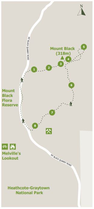
Points on map:
1. Ruts and erosion - surfaces may be unstable. Take care with your footing.
2. A fossil opportunity - sandstones litter the ground. Look for ancient sea bed fossils.
3. Beginning of the ridge line
4. Trig Point
5. Great views
6. View to Melville's Lookout
7. In the gully
8. Mt Black Quarry
Interactive Map
Walk Options
Long walk: An 11km return walk commencing at the corner of Mt Black Quarry Rd and Nagambie-Heathcote Rd
Double header: A 6km walk commencing at the Mt Black Quarry site to cover both Melville's Lookout on Bob's Bluff and the Mt Black summit loop.
There are no amenities other than a car park. March flies can be a problem in Autumn.
Access for Dogs:
Doga are not permitted.
Location
Mt Black Quarry Road, Wirrate 3608 Map
Web Links
→ Walk Notes - Mt Black Walk (PDF)
→ Mt Black Walk, Wirrate (Walking Maps)
")


")