Wirrate - Melville's Lookout Track

Your destination is bushranger Captain Melville's Lookout which is a moderate level 10.5km return walk. This is Victoria's largest remaining box-ironbark forest and it also has a diverse population of fascinating grass trees.
Melville's Lookout is named after Captain (Francis) Melville, who was a notorious goldrush era bushranger. After being transported to Australia at age 15 for housebreaking, he escaped Port Arthur to live with local aborigines for a year. He came to Victoria in 1851. Within a short time he had formed the Mt Macedon Gang that robbed travellers heading to and from the goldfields.
Mt Black Quarry can be viewed from the Lookout track. Granite blocks were mined here to use in the construction of the Goulburn Weir wall in the 1890's.
This park comprises Victoria's largest remaining box - ironbark forest, consisting of open woodland including ironbark, grey and yellow box and stringy bark. The understory features blackwood, gold dust wattle, silver wattle and drooping cassinia. Grass trees are numerous. Green rock fern is a common ground plant in milder months.
Wildflowers include grassland wood sorrel, shiny everlastings, tall bluebells and Nodding Greenhood orchids, with many more according to the season. Rare spider orchids may be also found.
Location
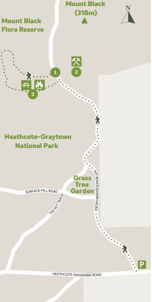
The track starts at the carpark (of sorts) on the corner of Mt Black Quarry Rd and Heathcote - Nagambie Rd, Wirrate, 20km west of Nagambie.
Map of Walk Route
Points on map:
1. Car Park - Corner of Mt Black Quarry Road. The main part of the track comprises Mt Black Quarry Rd. This is a dirt vehicle track with very little traffic. Take care, loose stones can make the track slippery. The track rises gently for 3.6km, where it arrives at the base of a steep, rough foot trail that ascends directly to the Lookout (at 4.2km). This foot trail then joins the dirt vehicle track on the opposite side of the summit. This dirt vehicle track loops back to the base of the hill. If the initial steep foot trail ascent looks too daunting, keep walking along the road approximately 100 metres until you get to the Melville's Lookout 2km directional sign pointing left. Follow this track up and back down for a less demanding walk.
2. Mt Black Quarry - To the right of the Melville's Lookout sign you will see remains of the old Goulburn Weir quarry site. This area invites exploring. Kids will love it for all the climbing and hiding places. It makes for excellent mountain biking as well.
3. Melville's Lookout - Stay for a while and enjoy the view, there are picnic tables and fire places available,
so make yourself comfortable and spend some time
Options
- For a shorter walk, you can comfortably 2WD drive in on Mt Black Quarry Rd to the base of the Melville's Lookout.
- A 4WD can take you all the way to the Lookout on the summit vehicle track, 2km from the Melville's Lookout directional sign.
- Walking 800 metres further along Mt Black Quarry Rd brings you to a walking track on the right going up to the Mt Black summit.
- The nearest camping is permitted at Spring Creek or Dargile Camping and Picnic Grounds or the Whroo free camping area.
Location
Cnr Mt Black Quarry Road and Heathcote-Nagambie Road, Wirrate 3608 Map
Web Links
→ Walk Notes - Melvilles Lookout Track (PDF)
→ Melvilles Lookout Walk, Wirrate (Walking Maps)
")


")