Winton North - Winton Wetlands Art Trail

There is an art trail in the Winton Wetlands which encompasses the following artworks.
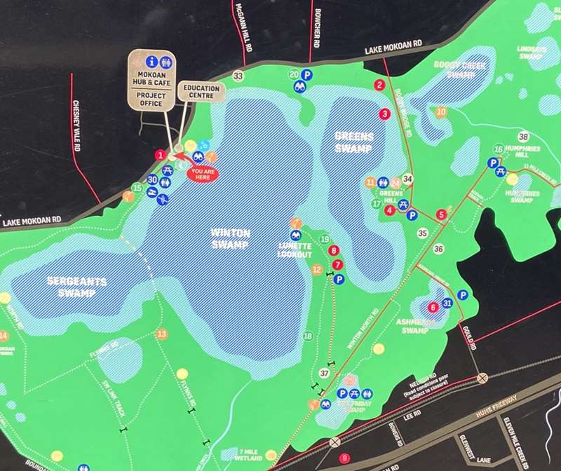
The location of each artwork is shown on the map is a red circle.
History of the Area
This beautiful landscape is marked with evidence of the changes and the stories that have shaped this site. The community has remained proactive and cohesive in spite of the site's turbulent and sometimes tragic history. In 1971 the area was inundated for irrigation, despite protests from the families that were displaced by the new Lake Mokoan, which was formed by building the longest dam wall [75km] in the southern hemisphere at the time.
Initially Lake Mokoan was a great success, providing a reliable water supply and a fantastic recreational resource. As time went by, blue-green algal blooms and high levels of evaporation called the efficiency of the reservoir into question.
The Victorian Minister for Environment and Climate Change created the Winton Wetlands Reserve and appointed the Winton Wetlands Committee of Management in April 2009, to restore the 8,750 hectare site following the decommissioning.
1. The Sanctuary - Andrew J Bourke
Location: Inside Mokoan Visitor Hub & Cafe, 652 Lake Mokoan Road, Chesney Vale
2. Martin's Barge
Location: Boggy Bridge Road entrance (off Lake Mokoan Road, Winton North)
This unexpected sight now tells one of the many stories of agricultural history within the reserve. Martin's Barge was used to transport young cattle over the water to Green's Island to graze. The cattle were fattened and prepared for market before being journeyed back to Boggy Bridge Road where they would be unloaded. The Martin family of Bungeet built the barge in the mid 1980s. The barge rests here at the high-water mark. Remains of yards that were built for barge landings can be found at the homestead on Greens Hill
3. Fish Trees - Tim Bowtell
Location: Boggy Bridge Road, Winton North
Tim Bowtell completed this fascinating an piece in 2016. Tim is a graphic designer turned artist; he loves to paint all manner of subjects and executes them in the most appropriate medium. Tim's work can be seen on various walls around North East Victoria and on display at North East Artisans in Benalla.
The fish panted here represent the Yellow Belly and Murray Cod that lived in Lake Mokoan. The blue and green rings are 5m up the trees to mark the maximum depth of Lake Mokoan.
The wetlands now provide habitat for a whole range of animals to thrive with its changing levels of water Murray Cod can still be found swimming in the ponds by the Dam wall.
Take a look in your mirror! In the days of Lake Mokoan, you would be swimming with the Murray Cod. Now you are likely to be sharing the area with wallabies, echidnas, goannas or even wombats.
4. Wren & Finch - Davidson Lopes
Location: Greens Hill area, side road off Boggy Bridge Road, Winton North
This area has a shelter with tables and seats plus toilets.
There is a 2.6km walk from the picnic area. This walk offers the opportunity to explore each historic phase of the site through its evidence of Aboriginal inhabitants, early European infrastructure remnants and ecological restoration.
Greens Hill was named after the Green family who established their farm here in the 1860s and resided at a property called Michaelrae, the remains of which can be seen at the end of this walk.
The inundation of the site meant much of the farm was lost and the hill became isolated - visible from many points of the Lake and known as Greens Island.
The island habitat is also important for a range of terrestrial fauna, including healthy populations of snakes, many of which share our tracks.
Telegraph Poles
The European history of this site tells a story of how people worked with the land and the formation of a strong and resilient community, thriving on good grazing country and the richness, beauty and diversity of the area.
Making fantastic use of a sturdy tree, you can see the evidence of the trees being used as telegraph poles across the site. Keep your eyes peeled and snap a shot of local history.
5. The CFA Tank - Guido Van Helton
Location: Cnr Boggy Bridge Road and Winton North Road, Winton North
This stunning visual tribute was created during the 2016 Wall-to-Wall Street Art Festival. Prior to commencing the artwork, renowned street artist, Guido Van Helten, met with members from local Country Fire Authority [CFA] brigades to gain inspiration The commission saw Guido incorporate portraits of three local volunteers, Colin Hooke from Chesney Vale Brigade, Robert Green of Taminick Brigade and Danielle Spokes of Winton Brigade.
Guido spent a weekend at the site transforming this concrete tank. An unexpected but fitting compliment to the contribution of CFA volunteers to our history, our landscape and our community, this artwork has received national and international acclaim for the striking expression it casts against the backdrop of lifeless river red gums.
6. Water Gallery - Troy Firebrace & Bailey Bish
Location: Along Ashmeads Swamp Road which branches off Winton North Road, Winton North
In partnership with the Wall-to-Wall Street Art Festival, the Water Gallery was added to this site in March 2017.
The project was designed, produced and executed by Yorta Yorta artist Troy Firebrace and contemporary artist Bailey Bish, merging their two styles to create a culturally significant landmark on this fantastic site. This is a beautiful spot for a kayak when the area is in flood, you will be able to paddle amongst the trees and see their reflections in the water.
7. Hilda Bain - Cam Scale
Location: Near Lunette Lookout. There is a 2.6km roughish track through a gate and across a paddock from Winton North Road, Winton North. From the parking place it is a 3km walk to the mural.
A lunette is a rare geological feature, a sand dune found on the edge of wetlands, formed by millennia of sand and soil movement across the swamps and forming a crescent moon shape. This landscape is extremely fragile and of significant archaeological importance.
Take a short drive (2.6km) to start your discovery of The Lunette and learn more about the wetland's history There is ample parking available where you can then commence your journey along The Lunette Walk (3km) or The Spit Walk [13km] We share this space with grazing animals, as well as wildlife, please drive carefully and return gates to the way you found them. Take only Memories, Leave only Footprints
8. The Long Neck Turtle - Kaiela Arts
Location: Near Lunette Lookout. There is a 2.6km roughish track through a gate and across a paddock from Winton North Road, Winton North. From the parking place it is a 3km walk to the mural.
9. Whitebellied Sea Eagle - Andrew J Bourke
Beside the Hume Highway.
There are many wallabies in the area, especially early and late in the day.
Note: The connection of Winton North Road and Nelson Road is closed. Retrace your path back to Lake Mokoan Road to exit the Winton Wetlands.
Location
Boggy Bridge Road, Winton North 3673 Map
")


")