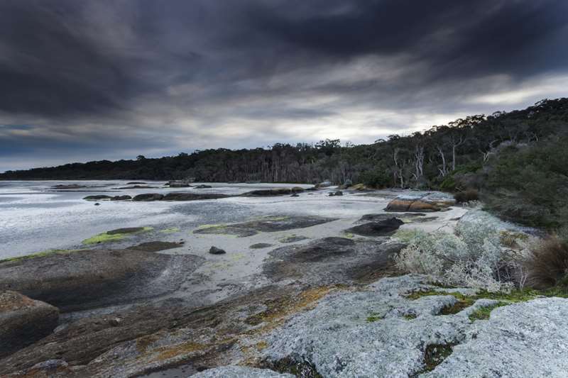
Tidal River - Wilsons Promontory National Park


Wilsons Promontory is the southernmost tip of the Australian mainland. From sun-drenched summer beaches to secluded winter walks amongst rainforest, the Prom is a park for all people in all seasons.
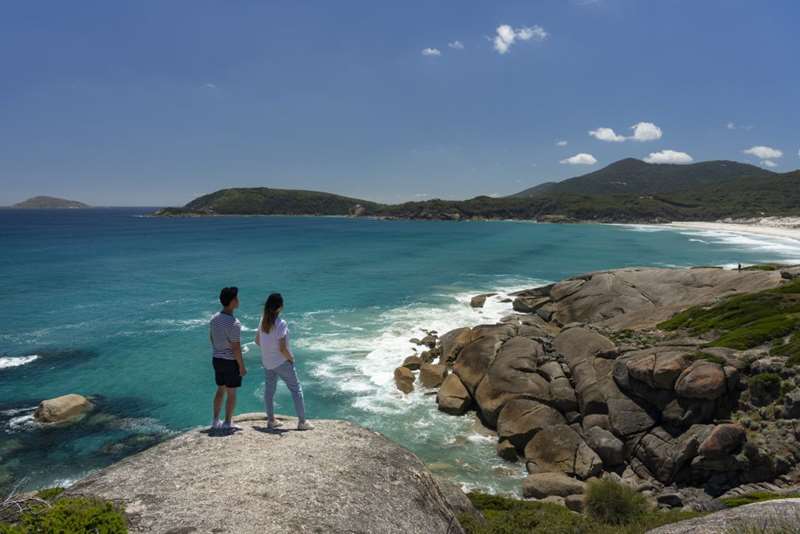
Wilsons Promontory National Park protects 50,460 hectares including pristine beaches, cool shaded rainforests, cloud soaked mountain peaks and rugged offshore islands. A remote historic lighthouse illuminates seas at the southern tip of the Prom.
Things to See and Do
Walking, camping, swimming, snorkelling, surfing, scuba diving, photography, bird watching, nature study, overnight hikes and simply relaxing are among the many things to do in this beautiful park.
Visiting for the day?
Day visitor entry to the park is free with the main visitor facilities located at Tidal River. Please exit the park before sunset.
Tidal River facilities
Campground facilities include amenity blocks, a playground, picnic areas, free gas barbecues and fresh drinking water. Call in to the Visitor Centre at Tidal River during open hours (8.30am - 4.00pm during AEST, 8.30am - 4.30pm during AEDST) or alternatively phone (03) 5680 9555.
Tidal River General Store stocks basic supermarket items as well as a range of souvenirs and camping gear. Hot and cold food is available from the cafe. There is no fuel at Tidal River. Fuel is available from the townships of Yanakie, Fish Creek and Foster (approximately 30-45 minutes drive).
Camping
Tidal River offers a wide range of camping and accommodation options. Fees apply. There are 484 campsites available at Tidal River, all beautifully situated near the beach. Twenty of these sites are powered and pre-booking is recommended. Toilets, hot showers, dishwashing stations and laundry facilities are provided.
Accommodation
Looking for a few more home luxuries, or enough beds for a large group? Choose from one of the Proms Wilderness Retreats, self-contained cabins, group lodges or huts. Advance booking of roofed accommodation is essential at all times. For bookings and enquiries phone: 13 1963 or (03) 5680 9555.
Access for all abilities
An all-terrain Trail-Rider wheelchair and beach access wheelchairs are available to use free of charge allowing mobility impaired visitors access to many of the Prom's beaches and walking tracks.
Most Popular Short Walks
The Prom offers wonderful walking opportunities for visitors of all ages and fitness levels. From short walks to day walks, pristine beaches to temperate rainforest, towering sand dunes to lookouts offering spectacular panoramic views, Wilsons Promontory has it all. Check out the Walking at Wilsons Prom Park Note which is attached below. Some of the more popular short walks at the Prom are:
Squeaky Beach (300 metres one way from Squeaky Beach car park, easy)
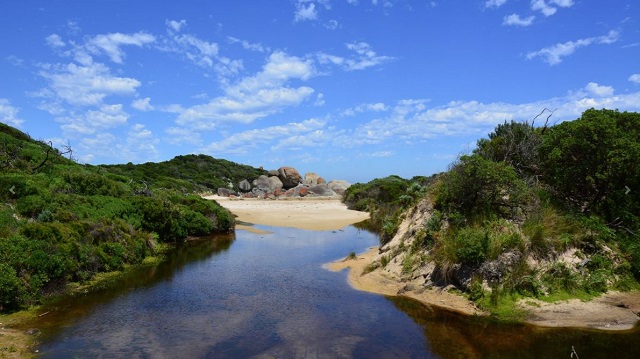
A short trail leads from the car park to this popular beach walking location. Take your shoes off and listen to the quartz sand squeak as you stroll beside rolling surf and wind-swept vegetation. For those with more energy, a walking track at the southern end of the beach ascends the headland of Pillar Point and follows Tidal River back to the main campground.
Lilly Pilly Gully nature walk (2.6 km one way, easy)
Starting at the Lilly Pilly Gully car park, this walk provides a glimpse of the Prom's interior, traversing heath land, eucalypt forest and a boardwalk through stands of warm temperate rainforest. Retrace your steps back to the car park.
Map of Lilly Pilly Area

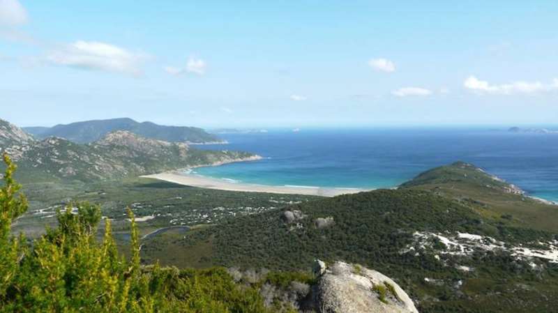
Mt Oberon Summit walk (3.4 km one way, moderate to hard)
Starting at Telegraph Saddle, follow the summit track gradually uphill to a 360 degree postcard Prom view from the top of Mt Oberon. Telegraph Saddle car park is closed during summer and Easter holidays, Melbourne Cup and Labour Day (March) long weekends and all weekends from November to Easter. At these times a shuttle bus operates between Tidal River (Norman Beach car park) and Telegraph Saddle, running via the Overnight Hikers car park.
Beach access
The west coast of the Prom has a number of beautiful and easily accessible beaches.
The safest swimming beach on the west coast of Wilsons Promontory is Norman Beach and its associated Tidal River. Other beaches are generally unsuitable for children. For example, Squeaky Beach frequently has a strong undertow, a rip and a steep sandy bottom.
Ocean swells or waves can crash along rocky shorelines catching people unaware. If fishing or walking along a rocky shoreline, always keep an eye to the sea.
1. Norman Beach (Various access points, distances & times. Easy)
Close to the Tidal River campground and flanked by Norman Point and Pillar Point, Norman Beach offers stunning views of Mt Oberon. Access from 2nd ramp at the Norman Beach car park, from 3rd, 4th or 5th ramp along 34th Avenue (no parking on 34th Avenue) or use one of the Tidal River access points behind 6th Avenue and follow the river to the beach. Surfing only permitted south of 5th ramp.
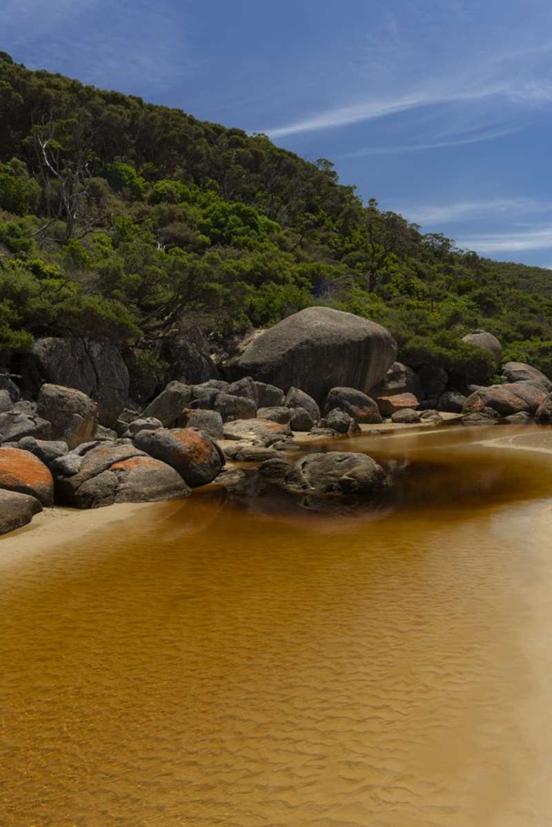
2. Squeaky Beach (300 metres from car park. Easy)
One of the iconic locations at the Prom, Squeaky Beach has rounded quartz sand that 'squeaks' when you walk on it. The rock formations at the north end of the beach create a maze of passages for fun exploration.
3. Picnic Bay (400 metres from car park. Moderate)
From the Picnic Bay car park a steep track with some steps leads down to this beautiful beach. Rock formations at both ends of the beach offer a range of intertidal rock pools to explore.
4. Whisky Bay (400 metres from car park. Moderate)
From the Whisky Bay car park, the track passes through a moist gully and then follows Whisky Creek before passing over a sand dune to a small sheltered beach with rock formations at each end.
5. Darby Beach (1.1km from car park. Easy)
Commencing at the Darby River car park, a sandy track follows Darby River as it winds its way to the coast. The small exposed beach is embraced at each end by rocky headlands. Please stay on the beach and avoid climbing fragile sand dunes.
Short walks around Tidal River
6. Loo-Errn Track (1km, 30 minutes. Easy)
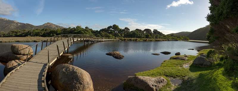
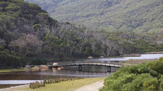
Designed for people with limited mobility, the Loo Errn track follows the south bank of Tidal River and provides access to the Tidal River footbridge. A short boardwalk (with platforms allowing access for fishing) protects the fragile wetlands. Start at the picnic area in the carpark opposite the Visitor Centre or at First Ramp on the west end of 6th Avenue.
7. Squeaky Beach Track (2.1 km, 50 minutes. Moderate)
Starting at the Tidal River footbridge, this popular walk offers spectacular coastal views as it climbs up and over the headland that separates Norman and Leonard Bays and descends to Squeaky Beach.
8. Squeaky Beach via Picnic Bay (2.5km, 1 hour, Moderate)
This coastal track combines the best of both beaches as it winds its way over Leonard Point to Squeaky Beach. Start at the Picnic Bay car park and walk to the southern end of Picnic Beach.
9. Pillar Point (Various distances and times, Easy / Moderate)
Pillar Point is an outcrop of granite boulders providing breathtaking views of Norman and Squeaky Beaches and the Prom's offshore islands. Pillar Point can be accessed from Squeaky Beach (2.8km) or Tidal River (1.8 km).'
10. Tidal Overlook (1.9 km, 40 minutes. Moderate)
Tidal Overlook is the highest point between Norman and Leonard Bays. A short side track leads to the Quiet Place, a special area dedicated to rangers worldwide who have lost their lives in the line of duty. Start at the Tidal River footbridge.
11. Tidal Overlook Circuit (3.8 km, 1.5 hours return. Moderate)
Incorporating walk 10, this walk loops around the headland between Norman and Leonard Bays before descending to the Lilly Pilly Link Track junction. Turn right to return to Tidal River.
12. Lilly Pilly Link Track (1 km, 20 minutes. Easy. Suitable for prams)
Commanding stunning views of Norman Beach and Tidal River this easy stroll links Tidal River with walks starting from the Lilly Pilly Gully car park. Spectacular spring wildflower displays can be seen in the coastal heathland. Start at the Tidal River footbridge.
13. Lilly Pilly Gully Nature Walk (2.6 km, 1 hour. Easy. Suitable for prams)
Starting at the Lilly Pilly Gully car park, this walk provides a glimpse of the Prom's interior, traversing heathland, eucalypt forest and a boardwalk through magical stands of warm temperate rainforest. Retrace your steps to the car park.
14. Lilly Pilly Gully Circuit (5.8 km, 2 - 3 hours return. Moderate)
Starting at the Lilly Pilly Gully car park (to the left of the toilets) the walk climbs across the southern face of Mt Bishop through stringy-bark forest before descending to the lush rainforest of Lilly Pilly Gully. Return to the car park via walk 13 described above.
15. Mt Bishop Track (3.7 km from carpark 1.5 hours. Moderate)
Follow the circuit track (walk 14) and turn off at the side track that leads to the rocky summit of Mt Bishop. Magnificent views are offered of the Prom's west coast and off shore islands. Steep, narrow path. Early sections are relatively easy-going, but track becomes narrower and more difficult as you climb. Retrace your steps to the car park or return via Lilly Pilly Gully (walk 13).
16. Picnic Bay to Whisky Bay (700m, 20 minutes. Moderate)
Commencing at the Picnic Bay carpark, this delightful walk meanders across coastal heathland to Whisky Bay. A viewing platform provides spectacular coastal views. The Picnic Point track between Whisky Beach and Picnic Bay has been permanently closed. Please do not access this area.
17. South Norman Beach, Norman Point, Little Oberon Bay (4.1 km, 1.5 hours. Easy / moderate)
Starting at the Terrace toilet block, the track veers left at the junction and climbs over Tea Tree shrouded sand dunes to the southern end of Norman Beach (1.5 km) then winds across Norman Point to Little Oberon Bay. The walk provides fantastic views across Wilsons Promontory Marine National Park to the Anser and Glennie Island groups. Norman Point is 300 metres from the main track. Beware of unprotected cliffs.
Short Walks in the North
18. Millers Landing Nature Walk (2 km, 40 mins. Easy)
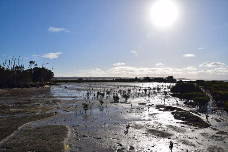
Start at Five Mile car park and turn left after the management gate. The walk passes through open banksia and stringybark woodland to Millers Landing and Corner Inlet. The Landing protects the southernmost stand of mangroves in the world.
19. Vereker Outlook (3 km one-way, 2 hours return. Moderate)
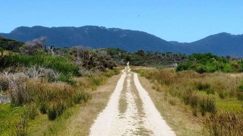
Starting at Five Mile car park, the track winds through open banksia woodland. Panoramic views to Darby Saddle, Corner Inlet and Cotters Beach are offered as the track climbs through stringybark forest and a tumble of granite boulders.
20. Millers Landing Link Track (1 km, 20 mins. Easy)
Winding through open heathy woodland, this short track provides great wildflower spotting opportunities and allows the visitor to combine both the Millers Landing (walk 18) and Vereker Outlook walk (walk 19). The link track can be approached from either end.
21. Big Drift (2 km, 40 mins. Moderate)
Starting at Stockyard Campsite near the park entrance, follow the signposts to the northern flank of Big Drift, an extensive series of inland sand dunes. It's easy to get lost in Big Drift so be careful to mark your path to find the track out again. There is no beach access from Big Drift.
22. Shallow Inlet (400 metres, 15 mins. Easy)
Commencing at Hourigan Camp Lane at the northern tip of the Prom, this short walk on a sandy surface provides beach access to Shallow Inlet via a sheltered gully of coastal tea-tree and swamp paperbark. The walk commences at the Hourigans Camp Lane carpark, which is accessed from Millar Road (off Meeniyan-Promontory Road). Miller Road is a loop road with one end before and the other just after Yanakie township from Fish Creek/Foster direction. Hourigans Camp Lane is located approximately halfway along Millar Road.
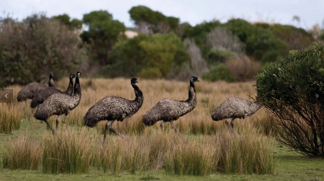
23. Prom Wildlife Walk (2.3 km return, 45 minutes Easy)
Located behind the wildlife viewing area, this walk provides perfect opportunities to view native wildlife including kangaroos, wallabies, emus and wombats. The Prom Wildlife is off Wilsons Promontory Road (between Yanakie Airstrip Track and Tin Pot Track).
24. Cotters Lake and Beach (1.2 km, 30 mins. Easy)
This easy walk passes through the often dry basin of Cotters Lake to Cotters Beach - a wild, windswept stretch of coast. Wildlife, including kangaroos and emus, are often sighted in this area. Start at the Cotters Lake car park and follow the management vehicle track past the gate.
Day walks
Plan carefully to ensure that you have enough daylight to complete these walks.
25. Norman Beach, Tidal Overlook, Squeaky Beach, Picnic Bay, Whisky Bay (6 km, 3 hours. Easy/Moderate)
This spectacular four beach walk combines all the features of walks 7 and 8 and 16 allowing the walker to fully experience the beauty of both land and sea at the Prom. Travel alternates between track and beach walking.
26. Darby River to Tongue Point (3.8 km, 2 hours. Moderate)
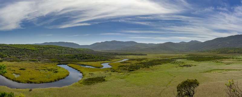
Start at the southern end of Darby River car park. Offering magnificent views of Darby Swamp, Vereker Range and Darby and Cotters Beach, this walk climbs gently through windswept coastal vegetation before turning off to Tongue Point - a coastal headland jewelled with stacks of weathered granite. The track ends prior to the semi-attached island. For your safety don't attempt to cross over to it.
27. Darby Saddle to Tongue Point (5.6 km, 2.5 hours. Moderate /Hard)
The Darby Saddle track provides spectacular coastal and forest scenery. At 2.1km a side track (300 metres) leads to Sparkes Lookout which offers views as far as the pyramid shaped Rodondo Island in the south and Shallow Inlet in the north. From the turnoff, the track climbs steeply to Lookout Rocks which offer views across to Norman Island. The track then descends steeply through low heathland to join the Darby River track which continues to Tongue Point. The track ends prior to the semi-attached
island. For your safety don't attempt to cross over to it.
28. Darby River, Fairy Cove, Tongue Point, Darby Saddle (9.4 km, 3 - 3.5 hours. Moderate / Hard)
This track combines all the features of walks 26 and 27, allowing the visitor to fully enjoy the stunning Tongue Point coastal area. The walk can be done in either direction however walkers will need to organise a car shuttle.
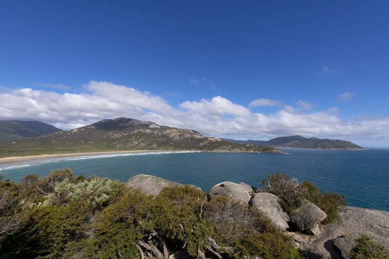
29. Mount Oberon Summit (3.4 km, 1 hour. Moderate / Hard)
Starting from the Telegraph Saddle car park, this iconic Prom walk follows the management vehicle track up Mount Oberon. Steps below the rocky summit lead to postcard perfect, panoramic views over Tidal River, the coast and offshore islands. Be prepared - even in summer months the summit can be windy, cool and clouded. Beware of unprotected cliffs.
30. Telegraph Saddle to Tidal River, via Oberon Bay (16.9 km, 5.5 hours. Easy / Moderate)
From Telegraph Saddle car park, follow Telegraph Track for 6 km and turn right to Oberon Bay. From Oberon Bay, the walk to Tidal River alternates between beach and track. Once at Norman Beach, either return to Tidal River along the beach or take the track signposted to Tidal River. Make arrangements to collect your car.
31. Sealers Cove (9.5 km, 3 hours. Moderate)
One of the most popular walks at the Prom, the Sealers Cove track climbs steadily to Windy Saddle and then downhill through beautiful forest to a boardwalk over Sealers Swamp.
Overnight hiking
The Prom provides some of Victoria's best coastal overnight or multiple night hiking opportunities. Hikers must be self sufficient as only basic camping facilities are provided in remote areas. Carry plenty of drinking water with you and know how to make untreated water safe for drinking.
Permits are required for all overnight hikes. Please talk to Parks Victoria staff before departing.
Hiking trails in the south take walkers past sheltered turquoise bays, where eucalypts tower over white sandy beaches. Tracks are well defined and toilets are available at all campsites.
The northern section of the Prom offers a remote wilderness experience. Some sections are undefined and hikers must be proficient in navigation with a map and compass. For more information please refer to the Overnight Hikes Park Note.
Lighthouses
South East Point (Wilsons Promontory) Lighthouse
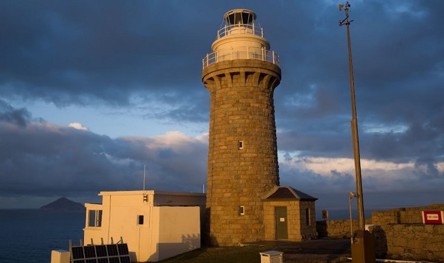
The Wilsons Promontory Lighthouse is the most southerly lighthouse on mainland Victoria. The 18 kilometre walk is well worth it to experience its spectacular location.
The Wilsons Promontory Lighthouse and keepers' cottages were built by convict labourers on a 90 metre cliff on the point, over the period 1853-1859, using locally sourced granite. The parabolic mirrors were replaced in 1975 by a generator-powered electric lamp array when the light was converted to electricity, which in turn was converted to solar power in 1993.
The rough circular stone tower was originally painted white. In the 1980s, the paintwork was stripped off, and the tower has been completely restored to the original stone finish. The white light, 117 metres above sea level, is visible for 25 miles.
Cliffy Island Lighthouse
Located on an island east of Wilsons Promontory. The island is accessible by helicopter only and the tower is not open to the public.
Visitor Information
Visiting for the day?
Discover 'Prom Country' with free app
Find out about South Gippsland walks, scenic drives, events, accommodation, dining and more. Download the 'Prom Country' Regional Tourism free app from the App Store or Google Play. Available on iPhone, iPad and Android devices.
Explore Wilsons Promontory with free map app
With Avenza Maps you can access offline maps, GPS location and digital map store on iPhone, iPad and Android devices. Download free maps of The Prom to locate visitor facilities and walking tracks, and calculate distances. Download the app from the App Store or Google Play.
Beware of Bluebottles
Bluebottles may be in this area, floating in the water or washed up on the shore. Avoid contact with Bluebottles. Their sting can cause significant pain. Seek medical attention if allergic reaction occurs.
Please stay out of the dunes on Squeaky Beach
The Prom's beaches are some of only a few places in south eastern Australia where the endangered Hooded Plovers continue to nest.
Beware of European Wasps
European Wasps can give multiple extremely painful stings. For your safety, cover exposed food and drinks. Seek medical attention f allergic reaction occurs.
No camping or staying in vehicles overnight
Camping or staying in vehicles overnight is not permitted on any beach or carpark within Wilsons Promontory National Park. Penalties apply. Camping and accommodation is available in Tidal River.
Fires are not permitted
This includes camp fires, wood fires and solid fuel barbeques. You are permitted to use portable gas barbeques. Further restrictions apply on days declared Total Fire Ban. Report fires to the onsite Duty Ranger. Penalties apply for lighting fires.
Drones are not permitted
The use of Remote Piloted Aircraft (e.g. drones) is prohibited without a permit obtained through a formal application with Parks Victoria.
Keep your food safe from wildlife
Feeding wildlife encourages aggressive behaviour towards people, makes native animals sick and encourages them to become dependent on humans for food. Penalties apply for offering or leaving food out for wildlife.
No glass on beaches
Glass bottles and vessels are not permitted on any Wilsons Promontory National Park beaches. Broken glass can cause serious injuries to people and wildlife. Penalties apply.
Please do not place rubbish or nappies in toilets
The toilet system will cease to function and is costly to repair. Bins are provided in the car park at the start of the beach track. Penalties apply for littering.
Dogs, cats and other domestic pets are not permitted.
Firearms and traps are prohibited.
Rubbish is your responsibility please take it home with you or dispose of it in bins at Tidal River. Penalties Apply.
EMERGENCY INFORMATION
Be fire ready, stay safe
DIAL 000 for police, fire and ambulance
Camping, accommodation, hiking and general enquiries can be made at the Visitor Centre at Tidal River. Open daily, hours vary seasonally.
For your safety
- Let someone know before you go. Tell a responsible friend or family member of your planned itinerary. Stay on walking tracks to avoid getting lost.
- For park related emergencies only (fire, accident/injury, injured wildlife, significant disturbance and critical maintenance issues), park visitors can contact the Tidal River Duty Officer (24 hours) on 1300 247 594.
- Mobile Phone coverage cannot be relied on.
- Wear sturdy walking shoes and carry drinking water, sunhat, sunscreen and waterproof clothing
- The safest swimming beach on the west coast of Wilsons Promontory is Norman Beach and its associated Tidal River. Other beaches are generally unsuitable for children. For example, Squeaky Beach frequently has a strong undertow, a rip and a steep sandy bottom
- Ocean swells or waves can crash along rocky shorelines, catching people unawares. If fishing or walking along a rocky shoreline always keep an eye to the sea
- Telegraph Saddle car park is closed during summer school holidays, Easter and on weekends from November to April. During these peak times, a shuttle bus operates between Tidal River and Telegraph Saddle. Timetables are displayed at the Tidal River Visitor Centre and at shuttle bus stops
- Wilsons Promontory National Park will close on Code Red Fire Danger days declared for the West and South Gippsland Total Fire Ban district.
Access for Dogs:
Dogs are not permitted within Wilsons Promontory National Park.
Review:
Wilsons Promontory National Park is a fantastic outdoor location to visit. If you are there on a day trip our favourite three locations/activities are:
Lilly Pilly Nature Walk

This is a 5.2km return family-friendly walk which initially passes through heathland and tall eucalypt trees before following a boardwalk through a stunning warm temperate rainforest area with lush ferns and a trickling creek. The track is predominantly compacted sand and fairly flat which means it is suitable for those with limited mobility of parents using a pram.
Rather than come back on the same path, you can return on the Lilly Pilly Circuit Walk (adds an extra 0.5km). This alternative route back to the car park has an optional accent of Mt Bishop.
Squeaky Beach

Squeaky Beach is truly an iconic destination, and yes the sand does really squeak when you walk on the sand. It is only a short 300m walk from the carpark to the beach. The beach has strong currents, unexpected large waves, submerged rocks and no lifesaving service which means care needs to be taken if you go swimming. The beach has large boulders to explore and a little creek runs from behind the beach.
Prom Wildlife Walk

A 2.3 km loop walk where you are almost guaranteed to see kangaroos/wallabies and emus.
Photos:
Location
Tidal River, Wilsons Promontory 3960 View Map
Web Links
→ Wilsons Promontory National Park (Parks Victoria)
→ Wilsons Promontory National Park - Visitor Guide (PDF)
→ Wilsons Promontory National Park - Walking at Wilsons Prom (PDF)
→ Wilsons Promontory National Park - Overnight Hikes (PDF)
→ Wilsons Promontory National Park - Short Walks in the North (PDF)
→ Wilsons Promontory National Park - Map Overview (PDF)
→ Wilsons Promontory National Park - Heritage Story (PDF)
→ All Aboard for the Prom - Heritage Story (PDF)
→ Cotters Lake and Beach Access Track (Parks Victoria)
→ Darby River to Tongue Point (Parks Victoria)
→ Shallow Inlet Walk (Parks Victoria)
→ Wilsons Promontory Lightstation (Parks Victoria)
→ Loo-Errn Walk (Parks Victoria)
→ Millers Landing Nature Walk (Parks Victoria)
→ Mount Bishop (Parks Victoria)
→ Mount Oberon (Parks Victoria)
→ Pillar Point Walk (Parks Victoria)
→ Tidal Overlook Circuit Walk (Parks Victoria)
→ Vereker Outlook Walk (Parks Victoria)


")