Wangaratta - Kaluna Park Walk


Kaluna Park is a 5.2 hectare natural remnant of River Red Gum riverine bushland within easy walking distance from the city centre. It is bordered by the King River, a billabong and a levee bank which separates it from Merriwa Park.
This area is a haven for wildlife including many species of woodland and wetland birds.
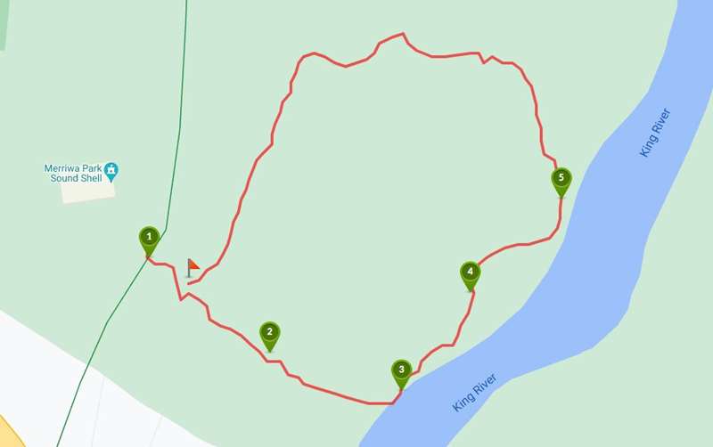
There are 1.2km of interlinked walking tracks with seats along the way and interpretive signage.
To access Kaluna Park the entrance is from the levee bank near the soundshell at the southern end of Merriwa Park. This area has toilets, two unshaded tables, bin and shaded BBQs.

Map of Route
Access for Dogs:
Dogs are permitted on leash.
Review:
Use the map to navigate along the paths through Kaluna Park. The bushland is a fairly wild natural environment with narrow tracks, lots of fallen trees (including some across the track), areas of thick vegetation, wetlands and the King River as a natural border. There are plenty of seats beside the tracks. We would be a bit wary of snakes during the warmer part of the year.
A Selection of Flora and Fauna in Kaluna Park
Flora
River Red Gum
Eucalyptus camaldulensis
Is the most widespread species of eucalypt in Australia occurring in every mainland state and is most common along watercourses. River Red Gums provide important nesting and breeding hollows for our birds and mammals including bats. For a hollow to form the tree needs to be more than 150 years old. Kaluna Park trees are estimated to be over 300 years old.
Blackwood
Acacia melanoxylon
Large shaped trees with rough bark and dense green foliage. Flowers are cream to pale yellow fairly large balls. These trees provide habitat and food for native fauna.
Silver Wattle
Acacia dealbata
Widespread trees, with soft, dull green fern-like foliage with bright yellow balls in racemes. They provide habitat and food for many native fauna.
Rough-barked Honey-myrtle
Melaleuca parvistaminea
With a strong, sweet fragrance the white-cream flowers attract many butterflies, moths and nectar-feeding birds. The Rough-barked Honey-myrtle provides important shelter and structural diversity to Kaluna Park.
Slender Knotweed
Persicaria decipiens
A sprawling wetland plant common in the Wangaratta area with tiny pink flowers in summer. The plants are an important component of water courses and wetlands as they filter the water and help prevent weed growth.
Weeping Grass
Microlaena stipoides
This widespread native tufted or mat-forming grass with a weeping flower stem is an important component of Kaluna Park ground cover. It has survived severe floods and droughts and has regenerated densely along the billabong and river, restricting weed growth and providing habitat.
River Bottlebrush
Callistemon sieberi
The River Bottlebrush is important as the roots stabilise the streambeds while the foliage provides shade. The River Bottlebrush provides an insect source for fish while the flowers are a nectar source for honeyeaters and butterflies. The foliage also provides good refuge for small birds.
Common Reed
Phragmites australis
Widespread erect semi-aquatic perennial grass, considered the tallest flowering grass growing up to a height of 3 metres with flowers in dense plume-like flower heads. The species is an important component of creek ecosystems and grows densely in and adjacent to the billabong in Kaluna Park. Plants also cover to animals and help prevent soil erosion.
Fauna
Tawny Frogmouth
Podargus strigoides
The Tawny Frogmouth is found throughout Australia and has the ability to be so still it seems to have become part of the tree! They catch their food by pouncing to the ground from a tree or other elevated perch. Kaluna Park has a couple of resident Tawny Frogmouths. Can you spot them?
Eastern Yellow Robin
Eopsaltria australis
With their yellow breasts and vocal behaviour Eastern Yellow Robins are a joy to watch. They feed on spiders, worms, moths, grasshoppers, wasps and flies. Their nest is cup shaped created from bark, spider webs and մամ.
Red-browed Firetail
Neochmia temporalis
These small birds live in the grassy areas of wet woodlands and open forests. Identified by their red brows these finches search on the ground for grass seeds and herb seeds. Red-browed Firetails build bottle-shaped nests from grass in thick bushes.
Barking Owl
Ninox connivens
This species of owl is a mid-sized bird which has a call that ranges from a bark (like a dog) to a shrill-like scream. They were widespread across eastern and northern Australia but now inhabit rare areas, waterways and woodlands. The Barking Owl is listed as threatened in Victoria and several pairs live in the Wangaratta area.
Common Ringtail Possum
Pseudocheirus peregrinus
The Common Ringtail Possum can be easily identified by the white end on the tail. They may build as many as five nests and will rarely move from one nest taking their young. Ringtails are leaf eaters and are one of only a few marsupials able to feed on eucalyptus leaves.
Platypus
Ornithorhynchus anatinus
Wangaratta has a number of resident Platypus living in the waterways. Platypus are a sign that the water quality is good and the native habitat is healthy. Platypus are most active at dusk and early morning.
Superb Fairy-wren
Malurus cyaneus
These beautiful little birds are generally found in family groups and because of their weak powers of flight require areas of dense ground foliage and a ready nest. Insects are their main food together with tiny seeds.
Maned (Wood) Duck
Chenonetta jubata
A land-dwelling duck of fine goose-like proportions with dark back and pale body. These birds inhabit lightly timbered country with access to short pasture and nearby water in these areas.
Photos:
Location
66 Ryley Street, Wangaratta 3677 View Map
Web Links
→ Kaluna Park, Billabong Loop Walk, Wangaratta (Walking Maps)


")