Strathbogie - Bridge to Bridge Walk

A lovely 2.2km return walk between Spring Creek Bridge and Smith's Bridge on the Seven Creeks. If you are observant, this riparian forest habitat is a good place to spot koala, rakali, echidna or platypus.
This walk meanders along the Seven Creeks and Spring Creek behind the township of Strathbogie. The track also passes the confluence of these two creeks, where the Seven Creeks heads west and flows towards Polly McQuinns Weir.
You'll walk beneath a canopy of Swamp Gums along the creek where you can see a variety of bird and animal life - ducks, bush birds, even koalas and platypus. Wooden benches are provided at intervals along the track and boards show information on local natural history.
At the southern end of the walk the track loops, so you can choose to walk either along the stream or across the floodplain, which is about 100m wide. If the weather has been very wet, or there has been heavy rain, parts of the floodplain track may be under water.
History of Strathbogie Township
From 1842 squatters took up a huge land holdings in the rugged Strathbogie Ranges and the tablelands to run thousands of sheep and cattle. Families arrived in the 1870's, and dairy and sheep were the driving industries in Strathbogie's early days and in the gold rush of the 1860's there were hundreds working the mines in the area. A second mining boom occurred in the 1940's with crystal mining to satisfy the quartz crystal component of early radios - crystal sets.
Vineyards are now another major industry in the area along with cattle, sheep and mining; as savvy growers and winemakers take advantage of the cool climate and rich granite soils of the area. Surrounded by forests, farmland and striking granite hills the environment is beautiful with its native bushland, birds and animals.
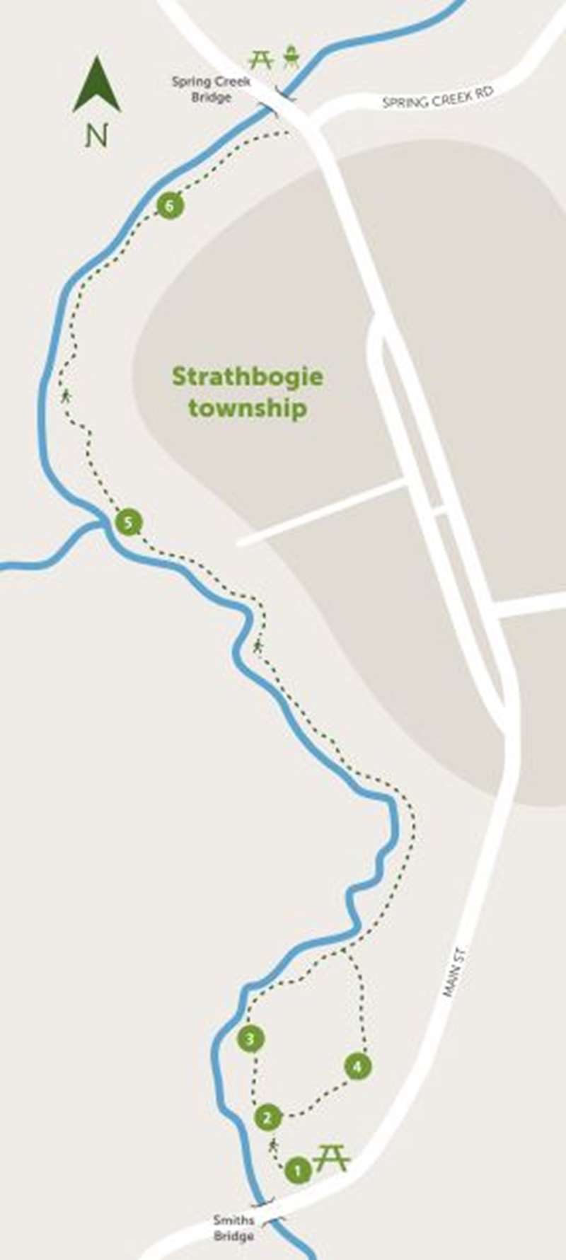
Location - Start the walk at either the Smiths Bridge day-visitor picnic area at the south end of town, or at the Spring Creek Bridge at the north end of town.
Map of Walk Route:
Get interactive map
Points of Interest:
1. Starting from the Smiths Bridge day-visitor area, view the information kiosk near the picnic tables to find out about the local area and fauna. Then take the path either to the left along the creek or the right along the floodplain - these paths meet up 150 m further on.
2. Information boards near the track junction explain some local fauna. This area was, until recently, overrun with weeds and exotic trees, which had to be cleared. The Strathbogie Landcare Group has planted hundreds of seedling trees and shrubs to rehabilitate the site.
3. Deep pools and cloudy water along the left-hand path along the creek are home to platypus.
Notice the many Silver Banksias and other shrubs that have been planted along the track, providing a nectar and pollen source for insects and honeyeaters.
4. The right-hand path follows the edge of the creek's floodplain, where the deep fertile soil is moist year-round. There is a small ephemeral pond along this path where herons sometimes stalk frogs. This pond is part of the old creek-line, which still flows after heavy rain or when the creek floods.
5. The confluence of the Seven Creeks and the Spring Creek is about 350m from the Spring Creek end of the walk.
6. Along the northern end of the walk at Spring Creek Bridge, the track follows the creek closely. Notice the rocky stream-bed and how clear the water is. Take care to stay on the path - the drop-off is sometimes steep.
Location
Main Street, Strathbogie 3666 Map
Web Links
→ Bridge to Bridge Walking Track Brochure (PDF)
→ Bridge to Bridge Walk, Strathbogie (Walking Maps)
")


")