Seymour Self-Guided Heritage Drive

Prior to the coming of the white man, the Taungurung people occupied a vast area along the catchments of the Goulburn River including this area that we now know as Seymour. In 1824 Hume and Hovell, on their return from Port Phillip, camped by the Goulburn River not far upstream of Seymour. In 1836 Major Mitchell crossed the Goulburn at Mitchellstown and soon afterwards overlanders and other early settlers began to use this crossing place. The mail service between Melbourne and Sydney had been going for just a year when it was found that a better route was available using the 'New Crossing Place'. An Inn was in operation there by the end of 1839. In 1841 the Government decided that the new crossing place was the likely spot for a town. Plans were laid before the Executive Council of NSW and Mitchell proposed the name Seymour which was approved on December 21st 1843. The town was named after Lord Seymour, the son of the 11th Duke of Somerset.
Map Showing Points of Interest
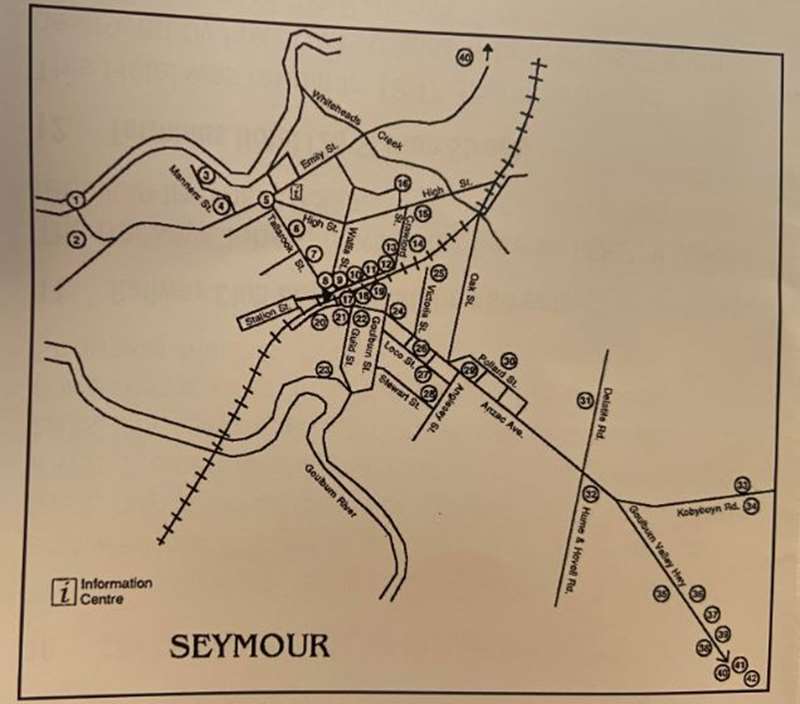
POINTS OF INTEREST
1. Goulburn River Bridge
The first bridge over the Goulburn was built in 1862-63. Tolls were collected until 1873. This bridge was built in 1892 and the Hume Highway crossed the river here until 1967. The bridge continued to serve as the crossing for traffic to Puckapunyal until the building of the Hume Freeway in 1982.
2. Somerset Crossing Winery, now The Winery Kitchen
The first vines were planted here in 1968 and grapes were processed on site for the first time in 1976. Originally known as Glengariff Winery and later being renamed as Seymour and Riverview Winery, it is now no longer an operating winery, but a popular and successful local restaurant, named The Winery Kitchen.
3. New Crossing Place Reserve/Lion's Park
This is the site of the New Crossing Place. By 1839 a punt was operating here and John Clark had established his "Robert Burns Inn" nearby. In 1841 the site for a police barracks was surveyed and in 1843 township allotments were surveyed on both sides of the river. Large floods in 1847, 1870 and 1916 contributed to the change of the course of the river, which can clearly be seen behind the Royal Hotel.
4. Site Of Robert Burns Inn
The original Robert Burns Inn was built by John Clark at this site at the end of 1839 and was the first established building in Seymour.
5. Heritage Precinct
The buildings in this area of Seymour are described in the Step Back in Time Brochure (available from the Visitor information Centre).
6. Former Shire Offices
Now the Seymour Club, this building was opened in 1974 on the site of former sale yards. It served as the offices for the Shire of Seymour, later to become the Rural City of Seymour, and also of the Seymour Water Board. Following the amalgamation of shires in 1994 the new Mitchell Shire Council operated from here for some months before relocating to Broadford. The Seymour Club commenced operation in 1998.
7. Seymour Express Office (36 Tallarook Street)
"The Seymour Express" was published from 1871 until 1924 when it was amalgamated with the "Seymour Telegraph". It operated from this building in the early 1900's.
8. Flood Marker (Corner of Station Street and Wallis Street)
Seymour has been inundated with floods on many occasions. In 1968 the Seymour and District Historical Society established this flood marker. The highest recorded flood was in 1916 while other huge floods occurred in 1870, 1917, 1934 and 1933.
9. Post Office (82 Station Street)
A new Post Office was built in Station Street in 1911 to replace the old one in Emily Street which had operated since it was built in 1872. The present Post Office was opened in 1971.
10. Site Of Town Hall (78-80 Station Street)
The Town Hall was built in 1902 as the Federal Hall and was later bought by the Seymour Shire to replace the Emily Street offices. For most of the 20th Century it was the centre of social events including meetings, balls, dances, theatre performances and movies. It was demolished in 1982 to build the present Shopping Mall.
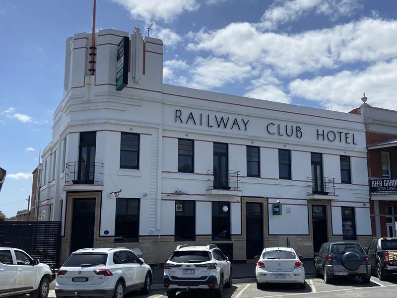
11. Railway Club Hotel (28 Station Street)
The Railway Club Hotel was built here in 1882 It was rebuilt in the mid 1930's.
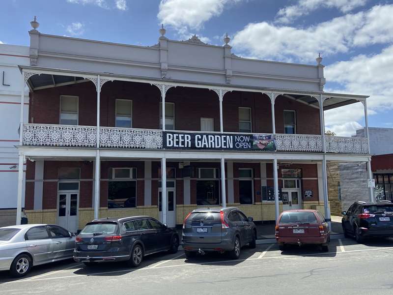
12. Terminus Hotel (26 Station Street)
This Hotel was rebuilt in 1897 after it had been destroyed by fire. It was originally built in 1873 soon after the arrival of the Railways. A number of other buildings in Station Street were built before 1900 and have been altered by varying amounts since then.
13. Uniting Church (15 Crawford Street)
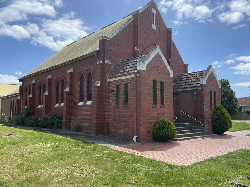
The Wesleyan or Methodist Church operated from 1865 to 1925 in Emily Street. The new Church in Crawford Street opened in March 1925. It was extended in 2001.
14. Pioneer Park (Crawford Street)
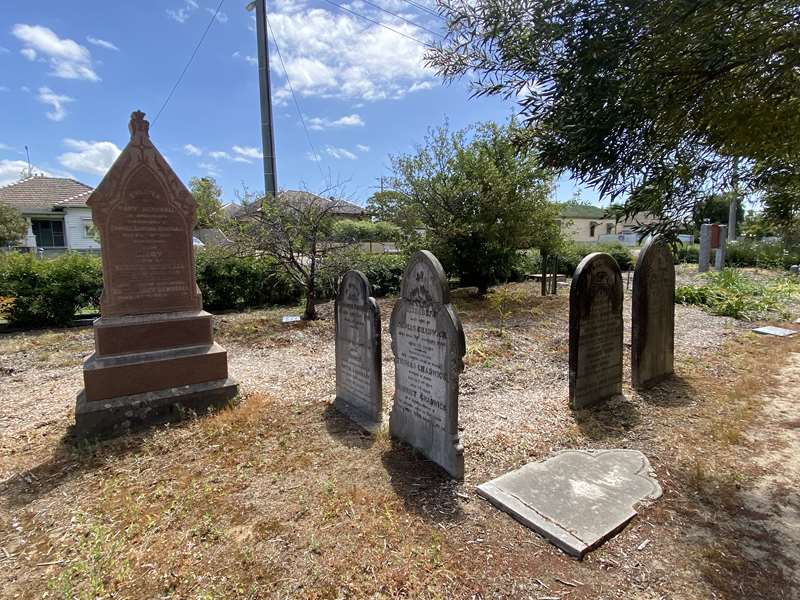
This cemetery was surveyed in 1850 and today is known as Pioneer Park following a project in 1985 to commemorate the 150th anniversary of the settlement of Victoria (then the Port Phillip District). The Memorial to all of those who are buried here was unveiled in 2001.
15. Roman Catholic Church And School (Corner Crawford and High Streets)
In 1939 the present Church was built to replace the old one which was first erected in 1872. The old Church became the Parish Hall and was eventually demolished in 2000. St Mary's Primary School began operation in 1880. In 1900 the Sisters of Mercy arrived in Seymour to found a convent and take over the running of the school. They also established Sacred Heart College in 1903. In 1988 the two schools amalgamated to form St Mary's College. The fence surrounding St Mary's College is built from the bricks the original Church.
16. Seymour Hospital and Karingal Seymour (Bretonneux Street)
In May 1920 the Seymour Memorial Hospital was opened and the Memorial Gates erected in 1927. A new Hospital was built in 1959 on adjacent land. Major extensions and renovations took place in 1996. The old Hospital was demolished in 1961 and the Karingal Elderly Persons Hostel was built on the site and opened in 1964. This was replaced in 2014 by a new hostel, Karingal Seymour.
17. Steam Train/Elliott Park (Anzac Avenue)
In 1965 the Seymour and District Historical Society purchased this Steam Loco and located it here at Elliot Park. In the adjacent Spirit of Progress Park there is a monument commemorating the centenary of the visit to Seymour by Lord Kitchener in 1910.
18. V.R.I. Building
This Victorian Railways Institute building was built in 1926 replacing an earlier one. It is used regularly by community groups today.
19. Railway Station
The Railway came to Seymour in 1872 and the Station was completed the following year. It has been added to over the years. The Refreshment Rooms provided an excellent service for travellers for many years.
20. Fire Station (Gordon Crescent)
The Seymour Volunteer Fire Brigade was formed in 1891 and a station was built soon after in Tallarook Street near the site of the present Bowling Club. In 1929 the station was shifted to its present site and in 2001 a new building was completed.
21. Presbyterian Church (Gordon Crescent)
The Presbyterian Church has been located at four different sites in Seymour. In 1870 the first Church was built on Manse Hill but was moved to Emily Street about 1876-77. In 1894 the Church again moved to Tallarook Street and in 1939 this new Church was opened on its present site.
22. Anglican Church (Anzac Avenue)
This Church was built in 1945 replacing the one in Emily Street which had operated from 1863.
23. Goulburn Park (Guild Street)
Goulburn Park originated in the 1920's. A swimming pool was constructed here in 1963 replacing the one in the Goulburn River just upstream of the Park. The pool was closed in 1991.
24. Masonic Lodge Hall (Anzac Avenue)
The Masonic Lodge came to Seymour in 1883. This Lodge Hall was built in 1901.
25. Railway Heritage Centre (Victoria Street)
The Railways came to Seymour in 1872 after a two year wait while a bridge was built across the Goulburn River. A new era began for the town with the coming of the Railways and the business centre of the town began its drift towards the station and away from Emily Street. Seymour quickly developed into a major Railway Centre. The Seymour Railway Heritage Centre preserves this heritage today. You can arrange a tour of this site by contacting the Centre directly.
26. War Memorial Cairn (Anzac Avenue)
Unveiled in 1986 this Cairn replaces the original Avenue of Trees planted in 1917 as a memorial to those who enlisted in World War I. The Trawool Road was renamed Anzac Avenue at that time. In 1982 the Avenue of Trees was removed to permit road duplication. In 2021, new oaks were planted to help to recreate the Avenue of Trees.
27. Site of Seymour Technical High School (Loco Street � Now Seymour College)
Secondary classes commenced in Seymour at the State School in Tallarook Street in 1918 and in the following year the Seymour Higher Elementary School was formed. The secondary students moved into buildings on this site in September 1922. The school became a High School in 1948 and was renamed Seymour Technical High School in 1978. Today it is part of Seymour College, which was formed in 2010.
28. Site of Seymour Primary School No.547 (Stewart Street � Now Seymour College)
In 1952 the infant classes of Seymour State School moved into new buildings on this site while other classes continued at Tallarook Street. Progressively over the following years additional buildings were constructed and by 1973 all classes were now housed on this site. Seymour College was formed in 2010 and the old buildings were replaced.
29. Seymour Library (125 Anzac Avenue)
The Seymour Library, now part of the Mitchell Shire Library, was opened here in 1977 after some years in temporary quarters.
30. Chittick Park (Pollard Street)
Chittick Park was formed in 1950. Today it is home to a wide range of sporting activities. The Seymour Sports and Aquatic Centre Stadium was opened in 1986 and the Heated Indoor Swimming Pool in 2002.
31. Site Of Seymour East Primary School No.4957 (Delatite Road)
Seymour East Primary School opened in 1967 at the Tallarook Street buildings of Seymour State School but by May 1967 the children moved into new buildings located here. The school became part of Seymour College in 2010.
32. Hume And Novell Monument (Anzac Avenue, near corner of Hume and Hovell Road)
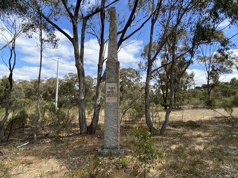
This Monument was unveiled in 1924 to commemorate the Centenary of the passing of Hume and Hovell near this spot on Boxing Day in 1824.
33. Seymour Racecourse (Kobyboyn Road)
Seymour has had race meetings since the 1840's but this course dates from the 1860's. In 1910 it was the centre of activities for a visit by Lord Kitchener who was inspecting Australia's military position. From 1927 until 1962 the Seymour Golf Course was also located here. The Grandstand was opened in 1965.
Photos:
Location
47 Emily Street, Seymour 3660 Map
")


")