Ruffy - Town & Country Walk

This is an attractive 4km long family farmland walk or romantic ramble. The loop adopts a never used road reserve of open woodland as a corridor to connect both sides of the Ruffy Township.
Map of Walk Route
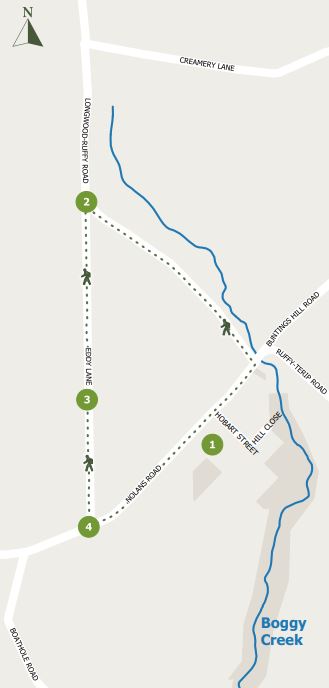
Points on map:
1. Ruffy Township
2. Eddy Lane entrance
3. A good spot for a rest
4. Nolan's Rd intersection
Interactive Map
Local History
Park anywhere in Ruffy's main thoroughfare, Nolans Rd. Outside the Ruffy Produce Store (open for bookings only), The Ruffy Hall or Community Centre are all convenient.
The Community Centre used to be the Primary School (1886 - 2005) and still has the advantage of a p playground out back for kids to enjoy. Many students rode horses to school and tethered them at the sale yards opposite. Keep your eyes open within the Township for information signs and plaques honouring local residents.
As you head east toward the CFA Shed corner, a challenge is to spot the one standing remnant of the Ruffy Hotel (next to the Hall). Built in 1888 and burnt in 1963, in its time it served as everything from accommodation and general store to drinking establishment and Post Office. Just what do you think this small concrete wall might have been for? Take your time to inspect the town along the way. It boasts charming a rural outlook in every direction.
The Walk
Once you leave the township the walk takes you onto sweeping vistas of the undulating Ruffy Tableland countryside. The walk closes a loop of 3 roads. The active public roads, Longwood - Ruffy Rd and Nolans Rd, may not carry much traffic, but there will be vehicles from time to time. Be mindful and keep to the shoulder on the right.
The Eddy Lane turnoff is marked by a sign post. However, there is no longer a sign. The Lane itself is not used as such, so look for the opening into the beginnings of a wooded corridor between grassy grazing properties.
This is an opportunity for a close encounter farmland walk, without worrying about entering private property. With kookaburras guiding the way, contented sheep to either side and bucolic views, it is a very pleasant way to spend a couple of hours. The track is grassy, generally dry and lined with beautiful eucalypt woodland. Along the way there is a small rise of granite boulders at the track zenith that makes for an agreeable picnic spot. Bird watching, photography, painting, rest and respite are suitable ways to enjoy this space
Location
There is plenty of parking space in town. Walk east to the CFA Shed and turn left into Longwood - Ruffy Rd. Walk 1.2km to the junction with Eddy Lane at 2040 Longwood - Ruffy Rd. Eddy Lane takes you 1.6km to Nolans Rd. Turn left and walk 1.1 km back to town.
Public toilets are located at the Ruffy Recreation Ground, Noye Lane.
Location
Corner Nolans Road and Longwood-Ruffy Road, Ruffy 3666 Map
Web Links
→ Walk Notes - Town & Country Walk (PDF)
→ Town and Country Walk, Ruffy (Walking Maps)
")


")