Ringwood Central Historic Walk (Ringwood)

A 4.5 km historical walk around the Ringwood area. The walk starts at the Ringwood Railway Station and refreshments are available at the Maroondah Highway Shops and Eastland.
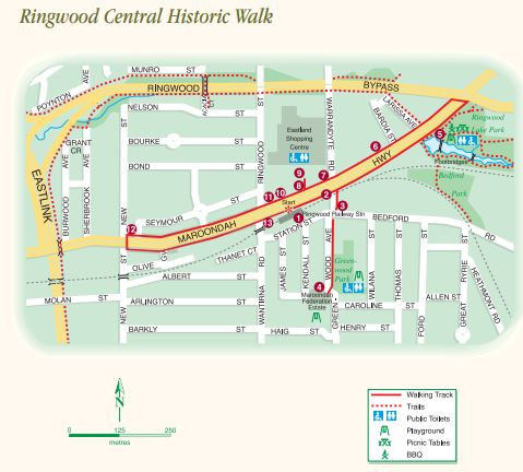
Route Description:
1. Ringwood Railway Station - Start at Ringwood Railway Station fronting Maroondah Highway. The station was built in 1889 after the railway line was extended from Hawthorn to Ringwood. The line was electrified in 1923.
2. The Clock Tower's original site - Proceed easterly to the intersection of Warrandyte Road and Maroondah Highway (in earlier times called Whitehorse Road or simply Main Street) to the original site of the Ringwood Memorial Clocktower. Erected in 1928, the clock tower was removed, and rebuilt in 1967 on its present site at the corner of Maroondah Highway and Wantirna Road.
3. Blood Bros Stores - Deviate under the railway viaduct to view the Blood Brothers store, built in 1914 and continuously operating for over 95 years.
4. Maroondah Federation Estate and Maroondah Art Gallery - Walk along Greenwood Avenue to number 32, the site of the former Ringwood Primary School. It is now a Council owned & managed community, cultural and arts facility. Return the same way back to Maroondah Highway.
5. Ringwood Lake - Continue easterly along Maroondah Highway, pause at Ringwood Lake, created in 1926 by the damming of Sandy Creek which used to follow the line of the gully and flow into Mullum Mullum Creek.
6. Ringwood Fire Station - Cross the highway and head west. The former Ringwood Fire Station was built in 1930 at a cost of seven thousand pounds and provided an important service for over 65 years. It is currently a restaurant.
7. Bamford's Timber Yards - Bamford's Timber Yards were a landmark at the northwestern corner of Warrandyte Road and were close to the majestic Block Buildings (1912) on the northeastern corner of Adelaide Street, demolished for Eastland.
8. Block Buildings & Coffee Palace - Block Buildings and the Ringwood Coffee Palace were amongst the earliest commercial premises in Ringwood, on the northwestern corner of Adelaide Street (now covered by Eastland Shopping Centre).
9. The Mail Office - Head north into the Eastland precinct, which in earlier years was home to The Pines Private Hospital, Ringwood Football Ground, and the offices of the Ringwood Mail.
10. Ringwood Town Hall - Return to the highway, at the northwestern corner of Melbourne Street, to the site of the Town Hall of the Borough of Ringwood, built in 1927 and demolished in 1970. The Borough of Ringwood became the City of Ringwood and merged with the City of Croydon (and parts of adjacent municipalities) in 1994 to become the City of Maroondah.
11. The State Savings Bank - A sign of prosperity in Ringwood was the construction of the State Savings Bank in 1923 at a cost of three thousand pounds. The building still exists behind an unsympathetic facade with a very different use.
12. Ringwood Timber & Trading Company Limited - On the north eastern corner of New Street, the Ringwood Timber & Trading Company constructed a fine building to cope with demand for building materials at the time of rapid residential development. Demolished in 1981.
13. Ringwood Co-operative Cool Stores - Crossing back to the south side of Maroondah Highway, wander back to the Clock Tower, located on the site of Ringwood Coolstores, evidence of the importance of Ringwood's orchard enterprises, built in 1911 and demolished in 1965.
Location
28 Station Street, Ringwood 3134 Map
Web Links
→ Ringwood Central Historic Walk Guide and Map (PDF)
")


")