Riddells Creek - Conglomerate Gully Reserve Walk


There is a 2.9km walk in Conglomerate Gully Reserve where the Western Grassland Plains meet the hills of the Macedon Ranges. The walk takes you through heathy dry forest and grassy dry forest vegetation types. The walk is steep and rocky in parts. Between October to December the reserve is one of the best places in the area to see native orchids.
The reserve has conglomerate rock formations and a small waterfall (seasonal), with native fauna and flora including six species of wattle. There is a "half way hut" which is a nice shelter to rest in.
Map of Route
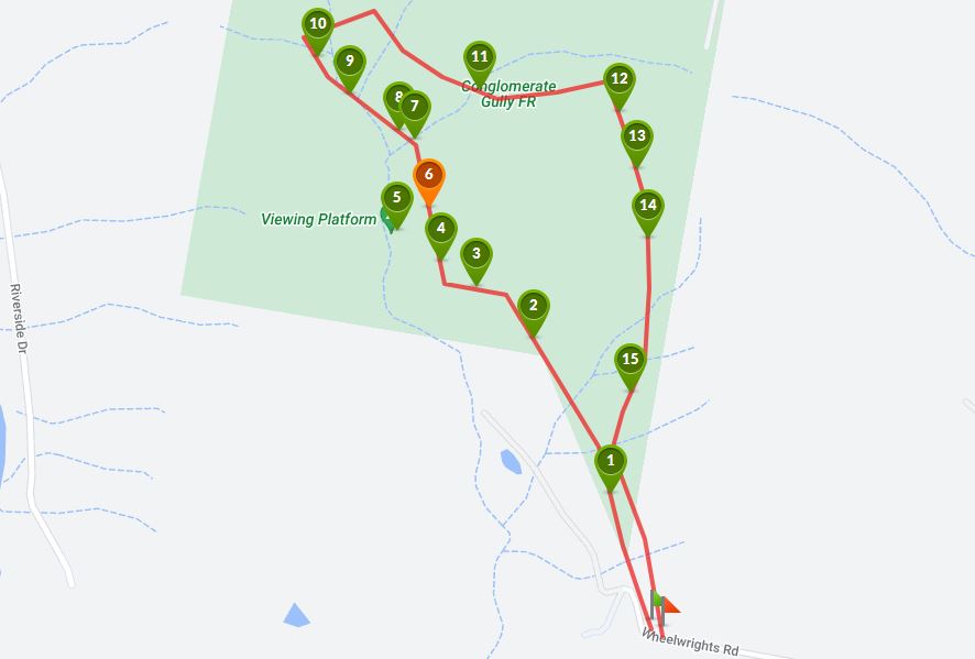
Interactive Map
There is a small carpark at the end of Wheelwrights Road from where the track starts. After a short distance the track is in the form of a loop and is well sign-posted with trail marker signs. It is difficult to get lost.
This is such an interesting walk with light bushland, rocky outcrops including a lookout over a gorge, a creek with waterfalls which flow after rain, wildlife (we saw kangaroos and lots of birds) and wildflowers and orchids in Spring. The reserve would be so great to visit after some rain when the creek is flowing.
Access for Dogs:
Dogs are permitted on leash.
History
Aborigines first entered this area between 20,000 and 30,000 years ago.
The clan usually found here was called Gunung-william Balluk. They occupied the grasslands and woodlands of the plains and foothills of the Macedon Ranges.
Game was plentiful in the area with Eastern Grey Kangaroos and Swamp Wallabies in abundance. This wildlife together with the fruits, nuts and herbs of the forests provided the Gunung-william Balluk clan with their physical needs.
They utilised the area for thousands of years before European settlers began to move into the area in the late 1830's. By 1840 most of the plains and foothills were occupied.
Since that time the land has had several owners. In more recent times Conglomerate Gully was the property of the McCutcheon family.
Until he left the Riddells Creek area in 1983 Mick McCutcheon was well known in the local community. He was a Romsey Shire Councillor for a term and served on various committees in Riddells Creek.
When the McCutcheon family left the area in 1983 they donated the Conglomerate Gully Flora Reserve to the Shire of Romsey. A Committee of Management and a Friends Group was established to look after the reserve.
The walking track, original information board and halfway shelter were built by the Shire of Romsey, the Committee of Management, the Riddells Creek Lions Club and the Friends Group.
The reserve was subsequently transferred, by the Shire of Romsey, to the Department of Conservation and Natural Resources, and is now under the management of Parks Victoria.
The most significant features of the reserve are its large variety of native orchids, the rock formation along the creek and two natural waterfalls when water is flowing.
The information shelter and interpretive material was erected, researched and presented by the Friends of the Macedon Ranges Inc with financial assistance from Parks Victoria's Community Grant Scheme.
Flora
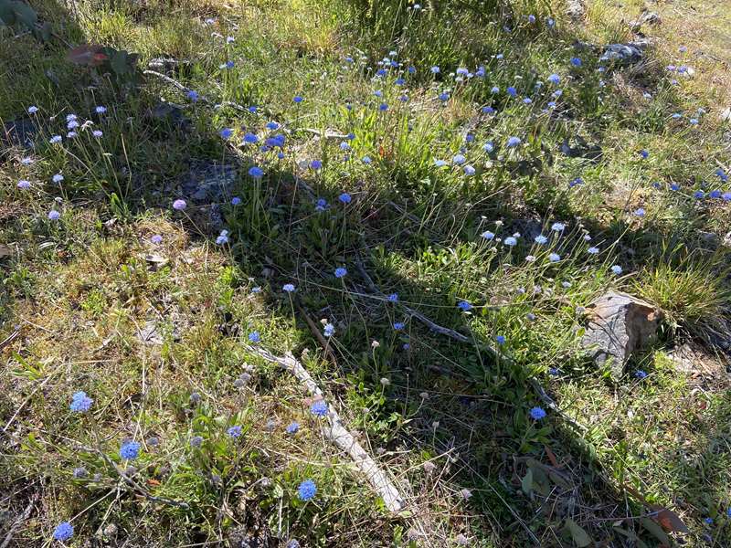
The entrance to the reserve is one of the best orchid areas in the Macedon Ranges and a wide range of orchids can be found flowering between late October to December, depending on climatic conditions. These include Tiger, Leopard and Purple Beard Orchids.
Conglomerate Gully is classified as Dry Sclerophyll Forest. These are open forests that receive low rainfall and are generally fairly exposed. On the upper slopes broad leaf peppermint dominates, with the occasional messmate. The species mix slowly reverses towards the lower slopes, as messmate, recognisable by its thick fibrous stringy-bark becomes the most common species.
Understory species are quite sparse throughout the reserve Wattle. They consist mainly of acacias including Black Wattle and the very prickly Hedge Wattle. These plants provide a great food and shelter source for the many bird species you see. The prickly shrubs are often used as nesting sites by small wrens and finches, as the prickly plants make it difficult for larger predators to pursue them.
The greatest diversity of plant species at Conglomerate Gully can be found at ground level. Native grasses, bracken, ferns, Milkmaids, Parrot Pea and Victoria's floral emblem the Common Heath, can all be found in abundance.
Other botanical curiosities found here include two species of sundews. These are tiny carnivorous plants that supplement their diet with occasional insect. Remember all native plants are protected.
Fauna
A variety of insects, reptiles, mammals, amphibians and birds occupy and depend on this habitat for food, shelter and nesting sites.
The native tussock grasses and shrubs provide protection and shelter for snakes and lizards. They find the rocky outcrops ideal for sunbaking. Most Australian snakes are venomous but they are generally shy creatures and given a chance will avoid human contact. If you see a snake leave it alone, and it will do likewise to you.
A variety of mammals are present within the reserve. The most common being the Brush-tailed and Ring-tailed Possums. Eastern Grey Kangaroos, Swamp Wallabies, wombats and Echidnas can also be found sheltering and feeding in the forest.
Water flowing down the gully during wetter months of the year creates ideal living conditions for frogs. If you sit quietly next to a pool of water you may hear the call of the common froglet and the southern toadlet.
The reserve provides some good opportunities for bird watching. Most of the species you will see are found throughout the Macedon Ranges. Some of the more common birds to be seen are the Crimson Rosella, Eastern Rosella, Flame Robin, Pied Currawong, raven and kookaburra. These and other bird species nest and feed in the surrounding forest. If you remain silent you will hear a variety of wonderful bird calls around you. Birds of prey such as the Wedge-tailed Eagle can sometimes be seen circling overhead in search of prey. Remember all native wildlife are protected.
Geology
Conglomerate Gully is named after the fine exposures of conglomerate rocks which can be found along the valley of the creek. These rocks are at least 370 million years old and most probably much older and formed long before the Macedon Ranges.
What are Conglomerates
Conglomerates are sedimentary rocks that are made up of rounded pebbles of other rocks which have been cemented together in a fine grained sand matrix.
In the Conglomerate Gully Flora Reserve rocks are rounded, flattened, whitish pebbles which are cemented together in fine reddish sand. The pebbles vary in size from 5cm up to 70cm with pebbles in the range 5-20cm most common.
How did they form?
The conglomerates at Conglomerate Gully are part of a unit of rocks known as the Kerrie Conglomerate which is exposed in various parts of the Macedon Ranges. The conglomerates were deposited in a system of broad, shallow, rapidly flowing streams. The water carried sand and rocks from nearby highlands, tumbling and shaping them into the smooth, rounded pebbles we find in the conglomerate.
The whole region was slowly subsiding, forming a depression which allowed a large thickness of conglomerate to accumulate. In the Black Range area the conglomerates are approximately 900m thick and about 840m thick at Mt Charlie. Substantial amounts of conglomerate have probably been removed by erosion so the original thickness would have been much greater. As the sediment accumulated the grains of sand and pebbles were cemented together under pressure of the overlying rock.
When were they deposited?
Unfortunately the conglomerates do not contain any fossils, because the right conditions did not occur for these formations, which makes precise age determination difficult by examining other features of the roicks it is possible to determine an approximate age.
The conglomerates overlie a series of sediments which were deposited in a deep ocean during the upper Ordovician period (approximately 440 million years old). These deep marine sediments were uplifted and folded and eroded before the conglomerates were deposited. The pebbles in the conglomerate represented material eroded out of these deep marine sediments. The conglomerate has also been heated up by the intrusion of granite nearby, which is late Devonian in age (approximately 370 million years). This gives an upper and lower age for the conglomerates of 440 - 370 million years. Geologists favour an older age for these rocks, towards the 440+ million years.
Formation of the Macedon Ranges
After the deposition of the conglomerates the Macedon Ranges region was affected by spectacular and catastrophic volcanism during the upper Devonian period (approximately 370 million years ago).
The volcanic complex which formed consists of an extremely thick sequence of silica-rich lavas (greater than 2km thick in places). These lavas were deposited in a 64km squared elliptical depression forced by the collapse of a large block of the earths crust. These volcanic rocks are very hard and much more resistant to weathering and erosion than the Ordovician deep marine sediments which they overlie. Hence the volcanics, which once filled a depression, now form the Macedon plateau rising some 400 metres above the surrounding lowlands. Associated with the period of volcanism was the intrusion of granite in the area. To produce the range in this way the region has obviously undergone major erosion.
Approximately 6 million years ago (recent in geological terms) other volcanoes which occurred during the Devonian period but were part of volcanic activity which was widespread over Victoria up until the last few thousand years. Good examples of these volcanic rocks can be seen at Mt Eliza and Camels Hump on Mt Macedon Range. This wave of volcanism affected the drainage and stream patterns of the region. Lava flowed down stream valleys, filling them in. New streams have established along the edge of the lava flows, such as Riddells Creek.
The drainage system at Conglomerate Gully was not affected by this volcanism. This region would have been like an island surrounded by lava as the conglomerates were at this time high points on the landscape. The Creek in Conglomerate Gully was probably established pre tertiary and may date back to the early Cretaceous (145 million years ago).
Photos:
Location
123 Wheelwrights Road, Riddells Creek 3431 Map
Web Links
→ Conglomerate Gully Nature Reserve (Walking Maps)
→ Conglomerate Gully (AllTrails)
→ Conglomerate Gully Walking Track (Bushwalking Blog)
→ Conglomerate Gully Walking Track (Green Trails)
")


")