Rhyll Historical Walk/Drive (Phillip Island)

With over 150 years of European history, the quaint seaside town of Rhyll has an abundance of historic sites and buildings worth discovering. This 3.5km return walking and driving tour will take you to sites including the post office, general store, pioneer houses and cottages, a sealers hut and Lady Nelson Point. The tour is marked by upright jetty timber posts showcasing informative bronze plaques so you can learn while you wander.
Pop into the Visitor Information Centres in Cowes or Newhaven to collect your own map, use the map and location key below or download the map here.
Historical Rhyll
1798: George Bass makes sounding of nine fathoms off Rhyll Bluff.
1801: (March) Lieutenant James Grant in 'Lady Nelson' names Lady Nelson Point at Rhyll as a memorial to his vessel.
(December) Lieutenant John Murray anchors off Lady Nelson Point and comes ashore at Rhyll.
1826: (November) Dumont D'Urville anchors under the Rhyll Bluff in 'Astrolabe', comes ashore, meets sealers and explores the hinterland. Ship's artist Louis de Sainson makes several paintings of Rhyll and Inlet.
(November) Captain Wright in 'Dragon' and Captain Weatherall in 'HMS Fly' anchor at Rhyll and come ashore to set up a fort and take formal possession, dig wells and clear four acres of land.
Walk Description
This Historical Walk is marked by a combination of upright Jetty Timber posts with Bronze Plaques and Cairns (markers).
This map groups these markers into three general areas.
For your convenience and safety we recommend that you park and walk for markers 1 - 8 and 12 - 16. Both areas have BBQ and toilet facilities. Markers 9 - 11 can be accessed by car before driving on to the southern coastal area, between the Jetty and Boat Ramp (markers 12 - 16). Please exercise caution when crossing all roads and walking along rural roadsides. Remember to face oncoming traffic where possible and watch out for cars with boats and trailers!
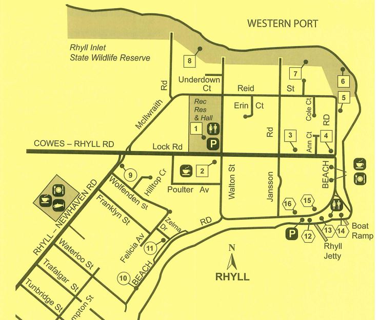
Key to Map
1. Walk/Drive starts at the Rhyll Mechanics Institute, 52 Lock Road, Rhyll. Park your car here to begin walk. Rhyll Mechanics Institute 1891.
2. Rhyll Post Office and General Store.
3. Jansson House c1893. 14 Lock Rd.
4. Site of Oystering settlement mid 1850-1860. 8 Beach Rd.
5. Site of Sealers' but 1826. Behind Rhyll Yacht Club boat yard.
6. Lady Nelson Point named by Lt. Grant 1801.
7. Site of Capt. Weatherall's Fort.
8. Underdown House c1900. Strawberry Farm c1920's - 1950's.
Return to your car via Walton Street
9. Drive up Lock Rd, turn left into Rhyll-Newhaven Rd & take immediate left into service road. Park here.
Cairn commemorating proclamation of Phillip Island as a British possession. Rhyll-Newhaven Rd.
Drive to No. 10 and 11 via Waterloo St
10. Rimutara Farm-gate on Beach Road
11. Capt. Lock's House c1869 and first site of the Rhyll Post Office. 1889. 4 Zelma Dr.
Continue to drive to No. 12 and park at the Rhyll Jetty carpark.
12.Rhyll Jetty and Goods Shed.
13.Historic Cairn commemorating George Bass Landing, 1798.
Capt. Wright's Well, 1826.
14. Plaque marking remains of ferry 'Ventnor' beached 1930; ferry 'Genista' sunk 1923; wreck of tug 'Minch'. ex Geelong.
15. Richardson House, 1887. Beach Rd opposite Map ref 13
16.Phillip Island and Western Port Steam Shipping Company Workshop and Storage Shed
- Length/Time - 3.5km return / 2 hours walking return
- Rated Easy/Moderate
- Surface is gravel, boardwalks and grass
- Parking at Mechanics Institute car park (gravel)
- No Designated Accessible Parking
- Toilets at Rhyll foreshore and the Mechanics Institute
- Designated Accessible Toilets at Rhyll foreshore
- Most of the walk is suitable for wheelchairs, some areas are grass and can be difficult to access in wet weather
- Suitable for Prams
- Bicycles permitted
Access for Dogs:
Dogs permitted on leash.
Location
52 Lock Road, Rhyll 3923 Map
Web Links
→ Rhyll Historical Walk/Drive Brochure (PDF)
")


")