Percydale Goldfields Heritage Tour

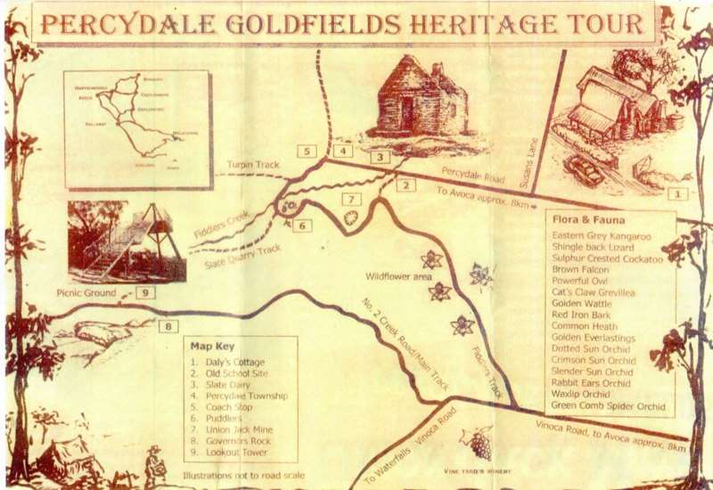
Map of Heritage Tour Route
Download Percydale Goldfields Heritage Tour Map
1. Daly's Cottage
James Daly who came from Kilfinane on the Shannon River in Ireland, built this cottage in 1865. The walls are built from fiddle back red gum found at the site. The men cut the timbers and the women used adzes to smooth it and show the wood grain. Handmade bricks were used on the pantry floor.
Nine children slept on a mezzanine floor in the back section with a groom looking after them. The walls were lined with newspaper, hessian and wallpaper. The house was occupied until the 1930s.
2. Percydale School
The gateposts and the sugar gum plantation remain at this site. There were 113 children registered in the 1870's and an average attendance of 40.
One part of the school is now the Avoca Hardware Store in the main street. Another section is now part of the old Maryborough East Primary School. The original school closed in 1942. The gateposts are all that can he seen today.
3. The Slate Dairy
Locally quarried slate was used by Thomas Hellings to build this dairy and another in Natte Yallock. The dairy was used for storing farming produce and possibly beer. John Healey owned the dairy in the 1870's. Local slate was used for roofing many buildings in Melbourne and Sydney and is still quarried today.
4. Percydale Township In the 1860's Percydale had two butchers, a hay and grain store, two hotels, a blacksmith, a dress shop, three banks, two grocers and a Chinese shop. Two churches, Cobb & Co. coach and horse yard, a post office and a police station next to the Temperance Hall. The Chinese population lived south of Fiddler's Creek, tended market gardens and mined the area for gold.
5. Cobb & Co
The Cobb & Co carriages travelled through Percydale from Adelaide to Melbourne.
6. Puddlers
Puddlers were used to break up the clay so that it could he put through a cradle to separate the gold. Water was needed and a hand built 'Chinese Dam' can he seen next to the two puddlers, which look like large doughnuts in the ground.
7. Union Jack Mine
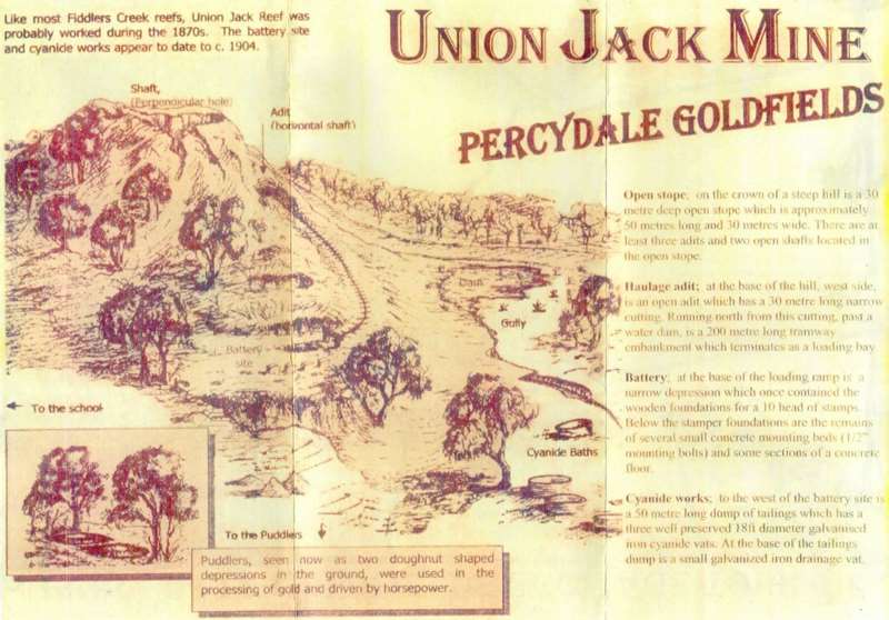
Map of Union Jack Mine
Download Union Jack Mine Map
Like most Fiddlers Creek reefs, Union Jack Reef was probably worked during the 1870s. The battery site and cyanide works appear to date to c.1904.
Puddlers, seen now as two doughnut shaped depressions in the ground, were used in the processing of gold and driven by horsepower.
Open Stope; On the crown of a steep hill is a 30 metre deep open stope which is approximately 50 metres long and 30 metres wide. There are at least three adits and two open shafts located in the open stope.
Haulage adit; At the base of the hill, west side, is an open adit which has a 30 metre long narrow cutting. Running north from this cutting, past a water dam, is a 200 metre long tramway embankment which terminates as a loading bay.
Battery; At the base of the loading ramp is a narrow depression which once contained the wooden foundations for a 10 head of stamps. Below the stamper foundations are the remains of several small concrete mounting beds (1/2" mounting bolts) and some sections of a concrete floor.
Cyanide works; To the west of the battery site is a 50 metre long dump of tailings which has a three well preserved 18ft diameter galvanised iron cyanide vats. At the base of the tailings dump is a small galvanized iron drainage vat.
1881. In quartz mining an important event was the purchase by the Union Jack Company of the claim of Hal and Inglis at Percydale.
1882. Operations had been suspended for a time at the West of England Hill and at the Union Jack mine, as the first crushing at Vale's Reel did not turn out as satisfactory as was expected.
1889. A few chains east of Luck's All Reef, the shaft was sunk 100 feet, and there was a large amount of water to contend with. For about three years the returns averaged over an ounce to the ton. The company had a good pumping plant and 12-head battery on the ground. Inundation of heavy water compelled the shaft to shut down.
1904. Percydale mining was practically at a standstill, as work at the Percydale Syndicate mine had been confined to surface prospecting alone and only one cyanide plant was working there.
8. Governors Rock
Sir Rohan Delacombe, Governor of Victoria, on his visit to commemorate the centenary of Avoca shire, stood on this rock on the 4th December 1964.
9. Lookout Tower
An unusual three-legged structure giving views over 70km on a clear day towards Mount Tarrengower (east) and Mt Beekworth (south).
Location
5 kilometers north of Avoca, off the Sunraysia Highway towards Moonambel. Turn left at sign on Percydale Road.
Once off the highway you will encounter travel road conditions that are passable at all times of the year in two wheel drive vehicles. Many of the other tracks throughout the Pyrenees Ranges are 4WD only. Please obtain detailed maps before undertaking these expeditions.
Car parking space is available throughout most of the area.
Walking time is short between most sites. The round trip between the central points 2-7 is approximately two km's.
Seasonal waterfalls can be experienced off Vinoca Road, follow the signposts.
Be wary of mineshafts throughout the Percydale and Pyrenees Ranges.
Location
Cnr Percydale Road and State Quarry Track, Percydale 3478 Map
Web Links
→ Percydale Goldfields Heritage Tour Map (PDF)
→ Union Jack Mine Map (PDF)
")


")