Northern Maribyrnong River Heritage Trail (Maribyrnong)

The Northern Maribyrnong River Heritage Trail showcases a few of the places that reveal the river's rich history of Aboriginal land use, early European settlement and exploration, industrial beginnings, munitions legacy and its many recreational uses.
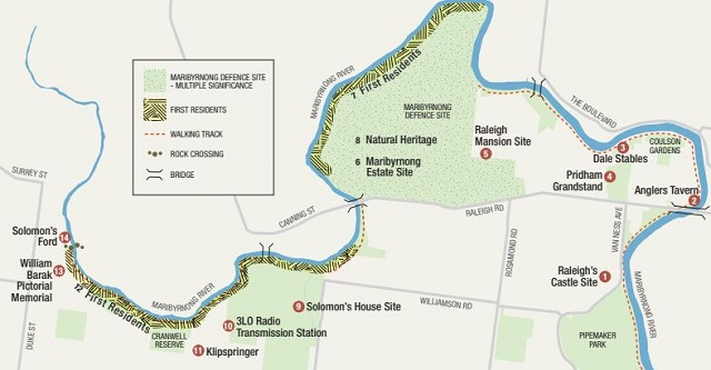
Route Map
Route Description
1. Raleigh Castle
Archaeological Site
Pioneering Maribyrnong pastoralist, Joseph Raleigh, built a structure named Malakof's Castle in the 1840s to house his single male employees who worked in his boiling down works close by. This striking building, with a sheep weathervane, was made of local bluestone and dominated the local landscape until it was demolished in the 1920s.
The boiling down works were processing 1,000 sheep a day at one time, because this was paying better than selling them for meat. Raleigh also had several pastoralist properties around Melbourne. He has been described as a prominent identity in the development of Maribyrnong and Raleigh Road is named after him.
2. Anglers Tavern
2 Raleigh Rd, Maribyrnong
The Anglers Tavern, also known as the Anglers Arms, was established in the 1860s next to a new bridge built in Raleigh Road. The hotel offered boating facilities for fishermen, as this was a well known fishing spot, and had a jetty for excursion boats to the popular Riverview Teagardens upstream.
Upstream the Maribyrnong River was free of industry and the river became the focus of recreation pursuits. This all changed after the Second World War and the river became neglected, however the tavern's popularity continues to this day. Being close to the river the Anglers Tavern was and still is regularly flooded.
3. Dale Stables
35 Chifley Dr, Maribyrnong
One of the many connections with horses and horse racing in Maribyrnong's thriving racing industry were the Dale Stables, nestled along the river near the corner of Plantation Street and Chifley Drive and built in 1931. The stables became a kind of horse motel for horses taking part in races at the nearby Maribyrnong Racetrack, Flemington Racecourse and harness racing at the Showgrounds.
There were about 20 stables available for short term and long term stays and horses came from as far as New Zealand to board at the stables. Records show the Dale family in the area from the early Twentieth Century, although the family had a pig farm in the area earlier and traded as farmers and butchers.
4. Pridham Grandstand
Built in 1935, the humble Pridham Grandstand at the Maribyrnong Reserve in Hortense Street became associated with the wild entertainment of racing cars and racing bikes at the reserve from 1946 until 1964. The races eventually closed due to pressure from local residents. Several thousand people gathered every Saturday night to watch these races.
Cr. Pridham, who was President of the Reserve Committee which built the grandstand, was connected to the well known Pridham family who manufactured meat products, tallow, fertiliser, sausage casings and other similar products in nearby Braybrook, emphasising the close relationship of industry and sport in the local region.
5. Raleigh Mansion
Archaeological Site (11 City View Dr, Maribyrnong)
Joseph Raleigh, who gave Raleigh Road its name, built a grand mansion on a hill in the middle of his extensive pastoral estate here in the late 1840s. At that time this mansion had views to the City of Melbourne and along the river in all directions. It was described as having flowers of every variety, orchards, vines and a general park like appearance.
6. Maribyrnong Estate
Maribyrnong Defence Site (Cordite Ave, Maribyrnong)
This area of Maribyrnong, once covered with a she-oak forest where there was an Aboriginal silcrete quarry, was the home of pioneers, famous race horses, a remount depot where horse were trained for World War One and eventually an explosives factory with more than 1,000 buildings which was central to Australia's war effort in both the first and second world wars.
After Joseph Raleigh had died the Fisher brothers moved into this area in the 1860s and set up the Maribyrnong horse stud, a significant step in Melbourne's developing horse racing industry. During World War One this estate then became the centre for training thousands of horses, which were still necessary for the logistics of war at the time.
7. First Residents
Maribyrnong Defence Site
The people of the Kulin Nation have lived in the Port Phillip area for at least 30,000 years. The Maribyrnong River and basalt plain provided the traditional owners of this land with a rich supply of food, water, shelter, tools, clothing and medicines. While few signs remain of this rich culture the former defence site is one of the places along the Maribyrnong River Valley that holds archaeological evidence of their way of life.
8. Natural Heritage - White Cypress
Maribyrnong Defence Site (Raleigh Road, Maribyrnong)
In the old Explosives Factory site were a number of indigenous White Cypress trees among the more dominant sheoaks of the area. The versatile wood of the cypress is soft, durable and aromatic and has been used for fencing flooring, panelling and furniture. It is termite proof but highly flammable. It is a small tree that can grow to 20 metres.
The estate area was generally forested with She-oaks, interspersed with White Cypress, but with Red Gums thick along the river banks and stretches of Grey Box and Yellow Box nearby. These trees were grouped around the river but gave way to grasslands not too far west. As you moved down river Paperbark and Ti-Tree took over.
9. Solomon's House
Archaeological Site
Joseph Solomon, one of Maribyrnong's earliest European pioneers, was a personal friend of John Batman and came to Victoria from Tasmania as part of the original Port Phillip Association. He obtained a licence to run sheep in the parish of Cut Paw Paw on the banks of the Maribyrnong and built a house on what is now the site of the Medway Golf Course.
Joseph Solomon, and his brother Judah, had been sent to Tasmania after being transported to Sydney from England for convictions of heavy handed re-possession of goods. They set up businesses in trading and land in both Tasmania and Victoria and brought their families out to the colonies to join them.
10. 3Lo Radio Transmission Station
The foundation remains of a 130 metre high radio mast, which was once the second largest radio transmitter in the Southern Hemisphere, can still be found at 170 Ashley Street. The mast, built by Amalgamated Wireless Australasia, was part of a plan to deliver public radio programs from Australia to the rest of the world and is significant for its association with major technical advances in Australia in the 1920s.
At the time Australia's communication with the rest of the world was quite limited, by boat, by morse code sent by underwater cable or by a series of intermediate radio transmission stations. The transmission facilities at Braybrook started in 1924, which was changed to shortwave in 1927 with a program called the Voice
11. Klipspringer
This is a beautiful art deco factory that was built in the 1920s when a number of meat byproduct industries were expanding into the Braybrook area. The company is known for its production of tennis racquet strings, particularly natural gut strings, an industry which grew in response to the growing popularity of tennis in the 1920s.
12. First Residents
River Valley Escarpment Braybrook
At the time of white exploration and settlement the Marin Balluk were the local clan and were part of the Woiwurrung language group, also known as the Wurundjeri, which were in turn part of a larger group known as the Kulin Nation. Marin Baluk meant the people at the big water or the Saltwater River.
Early settlers noted that the river valleys were often used as travelling routes by Aborigines and the Maribyrnong valley was a valuable food resource with abundant sources of food according to the season. At certain times of the year it teemed with fish and water birds and yams grew in the valley. The escarpment is a significant Aboriginal archaeological site.
13. William Barak Pictorial
Memorial (Duke Street Reserve, Braybrook)
Described as having a bible in one hand and a boomerang in the other, William Barak, last chief of the Wurundjeri tribe, never ceased arguing for the rights of his people. Barak was born 10 years before Batman arrived and negotiated his people through the trauma of displacement. He achieved lasting fame as an artist bringing different cultural traditions together.
14. Solomon's Ford
Canning Street Ford Braybrook
There is a line of rocks crossing over the Maribyrnong River, lining up with Burke Street in Braybrook on the south side of the river and the west end of Canning Street, known as Solomon's Ford. In the 1830s, before punts and bridges were in common use, this ford was the main crossing point on the river. The closest households to the ford were those of Cottrell, Ferguson and Solomon.
These rocks across the river as a crossing place are said to have first been identified by Charles Grimes in 1803. However, there has been a debate for some time as to whether this site is actually the original place that was called Solomon's Ford. Some say that this site is actually an Aboriginal fish trap and the real Solomon's Ford is further up the River nearer North Road.
Location
14 Belvedere Close, Maribyrnong 3032 View Map
Web Links
→ Northern Maribyrnong River Heritage Map and Guide (PDF)
→ Northern Maribyrnong River Heritage Map and Guide (on Google Maps)


")