Newhaven Historical Walk (Phillip Island)

Along the 3.5km Newhaven Historical Walk, you'll find yourself passing by a collection of historic sites on Phillip Island, including the old suspension bridge, St Pauls boys home, the original site of the post office and much more.
Pop into the Visitor Information Centres in Cowes or Newhaven to collect your own map or use the information below.
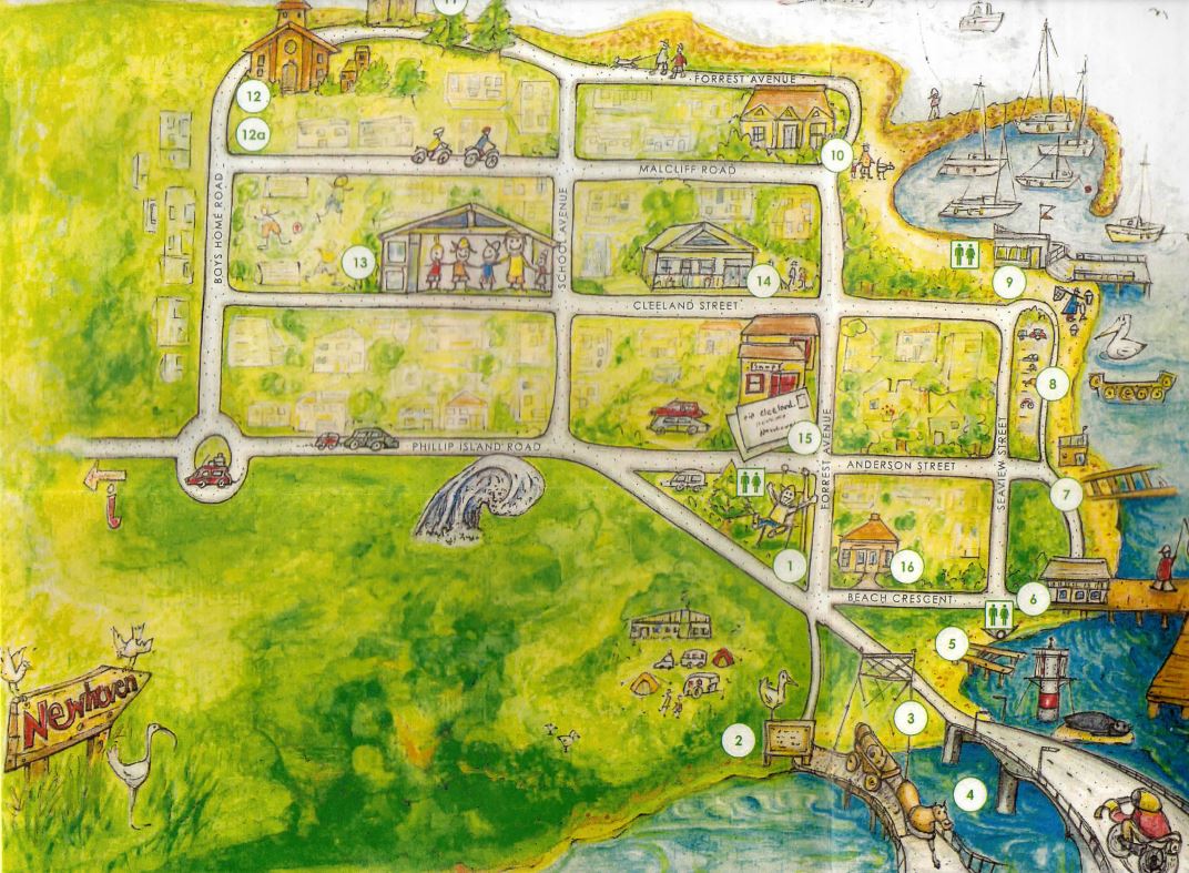
1. Begin your walk here at the Richard Grayden Memorial Reserve 2-4 Forrest Avenue, Newhaven. There is a playground with toilets here.
2. Plaque commemorating the site of the old suspension bridge between Newhaven and San Remo (1940)
3. The new concrete bridge (1969)
-embed01.jpg)
4. 'The Narrows' strong tidal flow in the entrance to Westernport Bay
5. Original jetty dinghy jetty and Newman's Private jetty
-embed02.jpg)
6. Newhaven jetty and large shed (1940)
7. Shipbuilding area (1905-1918) with winch and slipway
-embed03.jpg)
8. Boat trailer Park with boat ramp and jetty
9. Newhaven Yacht Squadron established in 1962. There are toilets on the west side of the pavilion overlooking the moored yachts.
-embed04.jpg)
10. Redcliffe House (c.1915)
11. The Pines beach and boatshed
-embed05.jpg)
12. St Paul's Boys Home (1928)
-embed06.jpg)
12a. Original Newhaven College site established in 1980 to 2017
13. Newhaven Primary School (Original 1892) rebuilt at its present site in 2001
14. Newhaven Hall
15. Newhaven Village. Original post Boxes moved here in 1975
16. Original site of the Post Office and general store (1873)
Newhaven History
Before the first bridge was built in 1940, the Island was dependent on boat transport. From 1908 till the 1920s, Mr R A Grayden rowed people across the narrows to Newhaven and stock had to swim across.
In 1929 a two car punt was used, then a 6 car punt in 1938.
The suspension bridge was opened in 1940 after much lobbying. It had a load limit of 6 tons, large milk tankers could not cross and tourist buses had to unload before crossing. A plaque commemorating this bridge remains in place on the Newhaven side.
A new concrete bridge was opened in 1969 at a cost of $3.2 million. The 700 metre long bridge includes a pedestrian walkway which offers good views over San Remo, the jetty and towards Phillip Island.
Newhaven Jetty area - This area includes original structures and boasts a long fishing history.
The old boat shed had a winch on the lower level of the foreshore car and trailer park which was operated by George Mapleson, who was a potato farmer from Poowong. It also had two railway lines to haul the boats in.
The large shed at the Newhaven jetty, was originally constructed by a local, David Selway, for processing locally sourced abalone for the export market.
Commercial fishing became an important activity, with boats from San Remo and Newhaven, across the channel on Phillip Island, operating in Bass Strait. In 1949, a Fishing Co-operative was formed to market and distribute the catch more efficiently. Recently a new fresh fish outlet has been established in Boys Home Road, Newhaven which sells fish caught in Bass Strait by local fishing boats.
The "Narrows" - the body of water that separates Phillip Island from San Remo.
Strong tidal flow reaching up to 6 knots exists at the narrows between Newhaven and San Remo. In May 2008, Atlantis Resources Corporation successfully completed the installation of a turbine named Nereus at Newhaven, near Phillip Island. This was later found to be unviable as an energy source and was decommissioned.
Yacht Squadron /marina
Phillip Island's only marina since 1962, Newhaven Yacht Squadron Marina, with 188 berths, provides an all weather safe haven for boats 6-12 metres. The club, which is run by volunteers, offers a comprehensive range of facilities for members and visitors.
Redcliffe House
Used as a guest house in 1924 and in 1937 opened its doors to under privileged children. During World War 2, it served as a women's refuge. In 1950, Redcliffe House was divided into flats. If has a charming verandah and wooden valance.
The Pines/Caravan Park/boatshed
The Caravan Park was situated between Forest Avenue and Malcliff Rd and the owners built the shed. Entrance to the park was between the two huge pines at the driveway of "Pelican Cove". Newhaven kids used to enjoy the Pines Beach and there was a kiosk at the caravan park where they used to buy "Sunny Boys" and lollies, while playing at the beach. The kiosk had a sash window and an old fashioned bell that you rang for service. The boatshed is on a 99 year lease and it had a long jetty made of railway lines. The sand on the beach was brought in from elsewhere.
Schooner Trusty
The schooner Trusty was built almost opposite Churchill Island. She was 61 tons, 69.8x17.9x7.5 feet and was launched at Newhaven on 11 December 1877 by the builder and owner Captain Alexander McLeod. It is believed McLeod owned the land fronting the shore west of the Boys Home. The long point there is known as McLeod Point. She was built for carrying coal from the Kilcunda mine but the mine closed due to financial difficulties about the same time as the Trusty was launched. She traded around the Australian coast with various cargo, from Wollongong NSW to Adelaide SA and the north coast of Tasmania. McLeod was crushed to death beneath the Trusty while blackening her bottom on the sand between the San Remo Jetty and the Coal Jetty on 4 March 1880. He is buried in the Phillip Island Cemetery.
St Pauls Boys Home
Built by the Anglican Church in 1928, this handsome building is historically interesting and has been classified by the National Trust. It began as a training school for delinquent boys aged 9-16 (1928-55) aiming to reform its inhabitants, then a home for boys (1955-73) and later, a camp - the St Paul's Discovery Centre for "disadvantaged children" (1979-2004) administered by the Mission of St James and St John. Recently sold, its future is unknown.
Newhaven Schools
Newhaven Primary School was established in 1892. It was completely rebuilt at its current site on the corner of School Avenue and Cleeland Street in 2001.
Newhaven College is a private Christian school operating from two campuses located at Boys Home Road, Newhaven and 1770 Phillip Island Tourist Road, Sunset Strip. The school opened its doors in 1980. The Newhaven campus closed at the end of 2017 and all P-12 classes were re-located to Sunset Strip.
Old Newhaven Village and Symes House
The Post Office opened on 1 January 1873 was situated at "Dutchies"on the corner of Forrest Rd and Phillip Island Rd. It also sold groceries. Later the owner, Tony Andrietta relocated to where the Island Healing centre now is and it closed in 1975. The PO boxes remain on the south wall of the 'new' building.
The residence behind the shops in Anderson Street, was called 'Newhaven House' and was originally owned by the Syme family (of The Age newspaper).
Phillip Island, Victoria map is illustrated by artist Pip Cleeland. Presented by the Newhaven Residents Group Inc.
Walk Summary:
- Length/Time: 3.5km / 1.5 hours
- Difficulty - Easy with made pathways
- Toilets located at Richard Grayden Memorial Reserve and Newhaven Jetty
- Designated Accessible Toilets - Yes
- Parking available at Richard Grayden Memorial Reserve
- No Designated Accessible Parking
- Wheelchair friendly
- Suitable for Prams
- Bicycles permitted
Access for Dogs:
Dogs permitted on leash.
Review:
A very pleasant walk which mainly runs around the coastal fringe of Newhaven which has nice views and a touch of history.
Photos:
Location
2 Forrest Avenue, Newhaven 3925 Map
")


")