Natimuk Heritage Trail

Until the 1940's an Aboriginal clan group known as the Djurite Balug, part Jardwadjali language group, lived in the area around Mount Arapiles. The name Natimuk reportedly comes from the Jardwadjali word for little creek.
Map of Heritage Trail
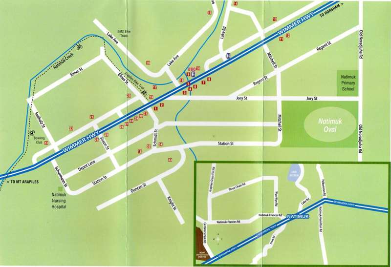
Download Natimuk Heritage Trail Map
1. Post Office, 3409: The post office in Natimuk was variously in a grain store and on Schmidt's farm on Lake Road.
2. Colonial Bank: Now a private residence this two storey building was originally the Colonial Bank built in 1888. It became the E.S & A. Bank in 1918 but this bank closed in 1930 during the depression.
3. 77 Main St: The Willows' was once a Doctor's residence. The vine covered brick shed to the right was at one time the bakehouse.
4. 71 Main St: At one stage was the home of Emmie and Hilda Schurmann. Hilda was a graduate from the Conservatorium of Music (Melb) and travelled the district as a music teacher.
5. In May 1893, James Carrol, a 48 year old proprietor of a coaching business, drowned here in the main street when he fell into swirling flood waters.
6. Hidden here is what is possibly the oldest commercial site in Natimuk which houses a dilapidated pioneer oven.
7. The National Hotel: The first National Hotel on this site was built in 1887, but like many of the earlier buildings in the town was burnt down in 1891. It was rebuilt in brick and re-opened in 1892.
8. The Natimuk Masonic Lodge was founded on December 21, 1897, however the present building was not to take its current form until 1953.
9. Shire Building: In 1994 The Shire of Arapiles was amalgamated with Horsham.
10. Court House: Was originally the chosen site for the Post Office, however opened as a court house in July 1891. At one point after WW1 the Court House doubled as a hospital during a fierce influenza outbreak in the town. It was gazetted as a Historical Museum on February 8th, 1964.
11. The Uniting Church: Was once the Presbyterian Church built in Natimuk, about the year 1877. The present building was moved to the current site around the time of the amalgamation when it became the Uniting Church.
12. Was once the home of Natimuks Catholic Church. Parishioners on 2nd May 2010 attended Mass for the last time in the 95 year old building. Now fully renovated the building has become a self-contained accommodation known as "The Old Church Natimuk".
13. St Aidan's Anglican Church: This church's congregation started in 1886.
14. This house however, now a private residence, was Dr Bird's Hospital for about 20 years. Doctor Bird came to Natimuk in 1895. Natimuk's original hospital, around the 1880's, was opened on the site of the present day RSL Hall in Main Street.
15. Our home: This hedge was originally carved by Don Emmerson, grader driver (1948), Shire overseer (1950) and Superintendent for Arapiles Shire from 1970 to when he retired in 1974. Emmerson divined the water for the Centenary Camping Ground at Mount Arapiles.
16. The present site of the saleyards was once Natimuk's largest industries, the flour mill belonging to Bretag and Kuse. Built around 1875 however in 1906 it was moved to a site near the old Railway Station. In January 1920, the then Noske's mill, burnt to the ground. This was a blow to the town's industry. There were reports of "the smell of burnt wheat permeating the town for weeks".
17. When the mill was operating the mill dam was built here on the creek. The Wartook to Natimuk/Arapiles channel was the first government irrigation channel system in Australia. The first water reached Natimuk on January 15th, 1888.
18. Historical marker. This plaque commemorates the passing by of Major Thomas Mitchell on July 22 1836.
19. The Memorial Band Rotunda: Originally built in 1921 the rotunda was a way to wind up a comfort fund started for WW1 soldiers.
20. This elegant old house, now a private residence, was once the Natimuk Hotel built be Heinrich Sudholz circa 1876. It was burnt by fire in 1881 and was rebuild in stone in 1884.
21. 84 Main St: This shed is all that remains if the Beard and Sission engineering works (1879) that in the late 1800's was the largest agricultural machine works in Victoria, employing 105 people in 1894.
22. Lutheran Church: The largest religious denomination in Natimuk is that of the Lutheran congregation. Services started as early as 1872.
23. Was once the Natimuk State School (No 1548) The school started on April 19, 1875 and had 170 pupils in its first year. In 1962 the new school at the other end of town opened.
24. The Fire Brigade started in 1890 and this building was put up in 1959.
25. 109 Main St: This house was built by the Rosel family. Lou Rosel was an early proprietor of the National Hotel. His mother sold shoes from the front room of this house.
26. 103 Main St: This limestone residence was an old police station
and a shed in the back yard is the old lock-up.
27. The Soldiers Memorial Hall: Originally called the Mechanics Institute this building has served many functions. On August the 15th 1891 the Natimuk Mechanics Hall was packed for a demonstration of the Edison phonograph.
28. 96 Main St Craft Shop: Was once a general purpose store.
29. Bakery: Built in 1897.
30. National Bank: This private residence and cafe was once the National Bank, which opened in 1908.
31. 91 Main St: The Natimuk Brass Band Hall. The band was formed' in 1885 but underwent a recess from 1930 to 1947 due to all their instruments being destroyed in a store fire.
32. Currently the home of an offshoot of Natimuk's new industry, rock-climbing. The brick garage was built in 1920 and in 1927 the adjacent power-house (which generated 230 volts), with electric street lights coming to Matimuk in March of the same year. The Natimuk Electric Supply joined with the SEC in late 1956.
33. The Silo: The distinctive concrete silo is the first sight many people get of Wimmera towns. This one first received wheat in December 1940 and has a capacity of 110,000 bushels.
34. 5 Schmidt St 'Flowerdale': Is the oldest standing house in Natimuk, built for the Schmidt family in the late 1870's.
Please note: Most of the buildings listed in this brochure are private property and should NOT be entered.
Location
Cnr Wimmera Highway and Schmidt Street, Natimuk 3409 Map
")


")