Nagambie - Goulburn Gates Walk

Park on either side of the river for this 4.9km return walk to view the four sets of Goulburn Gates that control water flow out of the weir into Northern Victoria's irrigation system.
Local History
In 1887 weir wall construction commenced on the Goulburn River at Nagambie. Work was completed in 1891 at a cost of 113,599 pounds. This was the first of Australia's significant irrigation network infrastructure, designed to control irrigation diversions throughout northern Victoria.
It was thought to be a visionary project at the time. The Weir would raise the Goulburn River level in such a way that water would flow by gravity along the three main irrigation waterways, Stuart Murray Canal, Cattanach Canal and the East Goulburn Main Channel. You will visit these in your walk.
The Stuart Murray Canal supplies parts of the Central Goulburn Irrigation System. Both the Stuart Murray Canal and Cattanach Canals divert water to Waranga Basin for extra supply to the Goulburn irrigation system. The East Goulburn Main Channel supplies the Shepparton Irrigation System.
Included in the construction was one of the first hydroelectric turbines. People came from all over to witness electric light as it lit the weir gates and the fine spray when the gates were open at night.
Evidence of the significance of the weir from its early days comes from in the form of the twenty years it was
depicted on the ten shilling note and the back of the half sovereign coin. It also became a significant location for recreational and social events.
The granite blocks of the downstream face were quarried at nearby Mt Black. The concrete walls were rooted in the underlying bedrock. The metal superstructure had cast iron piers supporting 21 cast iron and wrought iron gates. The gates were lowered into indentations in the top of the wall to allow river and flood flows. Lowering and raising the gates was powered by water driven turbines.
Stabilising and refurbishment works were undertaken in 1983 and 1988. Two of the original western gates and lifting gear have been preserved in recognition of this special piece of Victorian history.
Created by the weir upstream, Lake Nagambie is a great place to visit too. A popular place for fishing, it is also well known for water sports. Lake Nagambie is home to major annual events such as rowing regattas and water skiing.
Location
Car parks on either the east or west bank of the river cater for starting anywhere along this easy return walk. The walk is based on viewing 4 sets of Goulburn Gates controlling water flow out of the weir and into the main irrigation channels of the region.
Note: Weir wall crossings are closed at 4pm.
Map of Walk Route
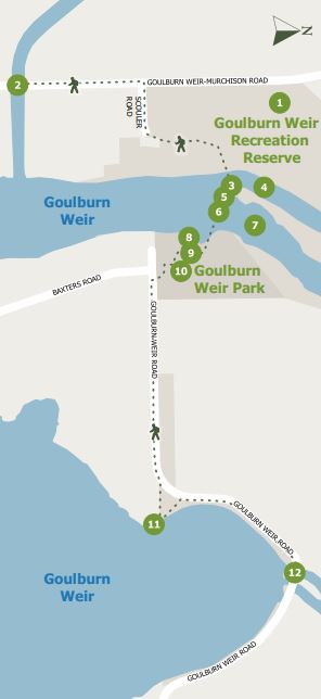
Points on map:
1. Goulburn Weir Recreation Reserve (west)
2. Cattanach Canal Gates
3. Control house and gears
4. Stuart Murray Canal
5. Gear systems
6. Goulburn River Gates
7. Goulburn River
8. Mobility assist device viewing area
9. Playground
10. BBQs, picnic grounds and toilets
11. River access
12. East Murchison Main Channel Gates
Interactive Map
Options: To shorten the walk by approximately 2km, simply exclude one set of gates from either side.
Facilities include car parking, a playground, BBQs, picnic tables an toilets.
Access for Dogs:
Dogs must be on-leash.
Location
240 Goulburn Weir Road, Nagambie 3608 Map
Web Links
→ Walk Notes - Goulburn Gates Walk (PDF)
→ Goulburn Gates Walk, Goulburn Weir (Walking Maps)
")


")