Myrtleford History Walk


This easy 1.8km walk highlights the significant historical aspects of Myrtleford and will take you around the town discovering what once was a thriving gold mining town.
Map with Stops
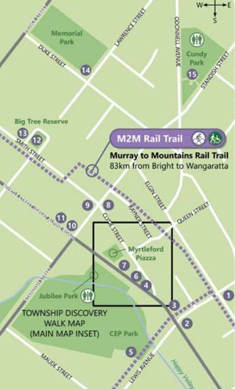
The following are the stops on the History Walk:
1. The Old School Museum
The Frank Vale Tablet: In recognition of his untiring efforts for State School 955 (1890-1910) a tablet was unveiled to honour the Head Teacher Frank Vale in November, 1924.
The Bills Horse Trough: This trough stood on the roadside opposite where the RSL Hall stands in Smith Street, to service horses in coach and transport work. Annis and George Bills had several horse troughs built and installed around Melbourne about the time George retired in 1908. The RSPCA made George a Life Governor in 1924 and after his death in 1927 the residue of his estate was left for providing horse troughs and for prevention of cruelty to animals.
2. The Linden Tree, Albert Street
The Linden (Lime) tree has been on this site since the 1860s, when it was visible in photographs of the original "Myrtle Creek Store". It saw the demolition of this old store and the erection of "Thomas Mathieson's Store", which still stands today.
3. The Uniting Church (formerly Methodist)
A memorial window honouring the loss of four cousins, two Matthews and two Willoughby men in World War 1 (Greater Love hath no Man...) dominates the entrance to the church; nearby a plaque commemorates the new church building in 1958.
4. The A.D. Lowerson V.C. Memorial Square
5. The Fire Brigade Training Track (see plaque)
6. The Post Office
Opened in 1971, this is Myrtleford's third post office on this site.
7. St Paul's Anglican Church & Rectory Fence
A stained glass window at the front of the church commemorates the death of Theatre Nursing Sister Alice O'Donnell who lost her life on the Hospital Ship "Centaur" when it was torpedoed by a Japanese submarine off Brisbane on May 14, 1943. To record Myrtleford's 100th anniversary in 1954, the Anglican parish joined in celebrations by erecting a stone fence which included a marble stone recognising the event.
8. The CWA Hall (now Presbyterian Church)
The CWA was at the forefront of rural women's affairs and played a vital role in developing facilities for infant welfare in the town. For 33 years, until 1959 the Infant Welfare services of the town were provided through the CWA Hall.
9. The Lone Pine (see plaque)
10. The Former Myrtleford Co-Store
After five years in Robertson street, the Co-Store established itself on this site in 1927, selling groceries, hardware and clothing.
11. Soldier's Memorial Hall & Supper Rooms
After World War 1, the hall was erected after much local fundraising in 1925. In 1936, extensions, a stage, and supper rooms were added.
12. The Big Tree
One of the oldest in the district, estimated to be around 500 years old, this heritage-listed tree is said to have been a meeting place for the First Peoples prior to their displacement from the valley following the arrival of the pastoral squatters in the region. The other "big tree" on the corner of Myrtle and Prince Streets enabled men and women to assemble separately under trees which were in close proximity to one another.
13. Senior Citizens Centre (see plaque)
14. Memorial Park (two brass plaques sit under the elm trees at the southern end of the oval)
15. Cundy Park (see plaque)
Location
29 Elgin Street, Myrtleford 3737 Map
")


")