Mt Cannibal Flora and Fauna Reserve Walk (Garfield North)

The 2.2km self-guided walk takes about 50 minutes and will introduce you to some of the plants and animals of the reserve. It is very steep in some sections and may be difficult for some visitors.
There is a playground in the reserve. Facilities including a shelter with table and BBQ, two unshaded tables and toilets.
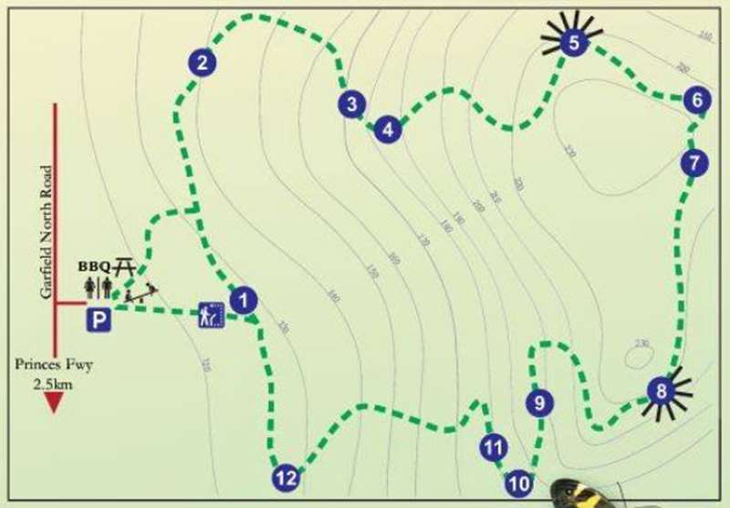
Welcome to the most identifiable peak in the eastern reaches of Cardinia Shire - Mt Cannibal Flora and Fauna Reserve. A number of theories have been put forward to explain the origin of the name 'Mt Cannibal'. The area may take its name from land leased in the area, in 1845, known as the 'Cannibal Creek Cattle Run'. The Mt Cannibal self-guided walk is a 2.2-kilometre loop track which takes about 50 minutes and will introduce you to some of the plants and animals of the reserve. The numbers in the map refer to the blue numbered posts along the track. But don't just look for the posts, keep an eye out and listen all the way.
1. The forest layers
The forest comprises three distinct layers. Trees are mainly silver-leaf stringybark (Eucalyptus cephalocarpa) and broad-leaved peppermint (Eucalyptus radiata) with some messmate (Eucalyptus obliqua).
Species in the understorey layer include silver banksia (Banksia marginata) which has a cone-shaped flower and common cassinia (Cassinia aculeata) - a slender dark-green bush with white flowers. The herb rich and grass layer is a combination of wildflowers, native grasses, orchids, and small creepers. Watch for changes in the vegetation as you travel throughout the reserve. Two distinctive vegetation communities exist in the reserve: heathy woodland in the lower area and, as you rise up the hill, the landscape becomes lowland forest.
2. The spiny spiders
This colourful spiny spider (Austracantha minax), is commonly found in this area in summer. The spider is black with spines, white spots and bright red legs. Females are almost double the size of males. They are also called the jewel spider or Christmas spider because they can be easily seen in December and January. Spiny spiders commonly build more than one web so they have more chance of catching their prey. They eat small insects, flies, mosquitoes and sometimes larger beetles. Their silk webs are purposely visible to larger mammals such as humans so they can be seen and won't be walked into. Look out for these spiders spinning their webs from shrub to shrub.
3. Introduced species
Weeds can grow and seed quickly, displacing slower growing local species and their associated wildlife. Sweet pittosporum (Pittosporum undulatum) is one of the most serious weeds in Cardinia Shire. It is a medium-sized bushy tree growing up to 14 metres high in favourable conditions, with dark-green shiny leaves, clusters of creamy-white, sweet-scented flowers in spring, and orange berries in autumn. Very little native vegetation can survive under its shady canopy. The Friends of Mt Cannibal group has been working in sections of the reserve and has cleared out a large amount of the pittosporum.
The berry-flowered heath (Erica baccans) Is a medium-sized shrub growing up to 2 metres high with attractive clusters of small, pink. bell-shaped flowers in spring. It was originally introduced for the cut flower trade. The Friends of Mt Cannibal group is actively removing these and other weeds and replacing them with locally grown indigenous plants.
4. Sit and listen
Take a seat here and listen to the birds that inhabit Mt Cannibal reserve. The yellow breasted robin seems to enjoy our company as does the grey fantail as it flies overhead. The tiny brown and striated thornbills go about their business in small groups as they acrobatically collect insects from the lower bushes. If you are lucky. you may see the white-throated treecreeper spiralling up a tree trunk as it works for insects. or hear its strident 'peet peet peet' sounding repeatedly.
5. Looking north
The aqueduct in the foreground divides the farming properties. It once delivered water from the Tarago Catchment to the Beaconsfield Reservoir to the West, providing water to Melbourne. The Black Snake Range forms the backdrop of the view with part of the Bunyip State Park which covers an area of 16,600 hectares.
This forest has the second highest population of forest owls in Victoria including the powerful masked and sooty owls. Owls and eagles fly though the forest each night and out into the farm land looking for prey.
6. Nature's lawn
This open grassland is a favourite feeding ground for eastern grey kangaroos (Macropus giganteus), swamp wallabies (Wettable bicolour), short-beaked echidnas (Tachyglossus actileatus) and the common wombat (Vombatus ursinus). These animals are most likely to be sighted either early in the morning or late in the afternoon. If you are not lucky enough to see one of these animals here you will most likely see traces of their scats (droppings), or soil disturbances which might be evidence of wombats and echidnas foraging for plants. roots and insects.
7. Eucalypts of the south
The mountain grey gum (Eucalyptus cypellocarpa) is a tree of the mountain forests, able to grow to 60 metres in favourable conditions. The bark at the top of the tree is white and grey and looks smooth, while at the base of the tree the bark sheds in strips.
The white stringybark (Eucalyptus globoidea) has thick, fissured bark and smallish leaves. This tree is only found on the southern slopes of the Great Dividing Range.
8. Southern lookout
At this point in the walk, you can view a range of southern landmarks including Western Port Bay, French Island, Phillip Island and Mornington Peninsula. Using the directional dial as a guide, see if you can spot Mt Worth or Queenscliff in the distance.
Looking southwards. the open grass and farmland in view was originally all swampland. The Koo Wee Rup swamp system extended from Bunyip in the east across to Pakenham, and down to Western Port Bay. This 450-square kilometre area was drained for agricultural purposes for 90 years from the 1870s.
From here you can also see the outer edges of the Mornington Peninsula and Western Port Biosphere reserve. The biosphere reserve is part of a world network recognised by the United Nations Education. Scientific and Cultural Organisation (UNESCO).
9. Rocky outcrop
As you walk down Mt Cannibal. you will notice a lot of large rocks. The vegetation around these rocks is specifically named a 'rock outcrop complex'. Scattered small trees and shrubs grow in between the large boulders. Some of the shrubs growing in these parts are prickly tea tree (Leptospermum continentale) and dusty miller (Spyridium parvifolium).
The small crevices and gaps in the rocks also make good homes for small mammals and reptiles. These large boulders are made from granite that is over 350 million years old. This granite outcrop is one of the largest displays in southern Victoria.
10. Kangaroo grass
Kangaroo grass (Themeda triandra) has slender stems and narrow leaves with golden-brown seed heads. This grass grows to less than half a metre. Unlike most grasses, it grows during the warmer months and is green during summer. The grass was used by the local Indigenous people to twine fish nets.
You will notice beautiful purple and maroon colours in the new spring flower inflorescence growth of this grass.
11. Dusty miller
Dusty miller (Spyridium parvifolium) has little round dark-green leaves that have a dusty silver colour on the surface. Dusty miller produces fragrant little white flowers from July to November.
12. Butterflies
Butterflies are delightful, fragile insects that are easily observed during the warmer months. Unlike moths, adult butterflies have few predators, though in the caterpillar stage they are more vulnerable.
The sword-grass brown butterfly (Tisiphone abeona albifascia) relies on the presence of the red-fruited sawsedge (Gahnia sieberiana) in this area near Hamilton Creek. While still in the caterpillar stage, the imperial white butterfly (Delias harpalyce) is only found on mistletoe.
Location: The reserve can be a bit tricky to find. From the Princes Highway, head north along Garfield North Road, continue past the turnoff for Cannibal Creek Reserve. After about 2.4 km from the highway the road changes to gravel and there is a big pond on the left. The road to the Reserve is on the right.
Access for Dogs:
No dogs allowed to help protect the unique environment.
Location
260 Garfield North Road, Garfield North 3814 Map
Web Links
→ Friends of Mt Cannibal Flora and Fauna Reserve on Facebook
→ Mt Cannibal Walking Trail Notes (PDF)
")


")