Point Leo Point Beach


The small settlement of Point Leo is set back from the 20 m high point, which is covered by a wide foreshore reserve. Three beaches surround the point: Point Leo Beach, the Point Beach and Point Leo Surf Beach.
Point Leo is a 20 m high, basalt bluff with a continuous sand beach at its base, and reef flats exposed at low tide. The Point Beach is 200 m long and faces south, but is partially protected by the extensive reef flats and offshore reefs known to surfers as The Peak. The foreshore reserve covers the point and includes camping and picnic facilities.
Swimming is not recommended, with the abundance of rock and reef on either side of the beach. Rips run out against the reefs when the surf is breaking. Swimming is safer at the adjoining bay or patrolled surf beaches.
The focal point of Point Leo is the point itself. The beach is better suited for sunbathing, while the surf, when running, is for more experienced surfers.
The beach has a General Beach Hazard Rating of 4/10 (Moderately hazardous)
Access for Dogs:
Dogs are prohibited from the beach between 9am and 7pm throughout the Daylight Saving period. Outside of these times, dogs must be on leash at all times.
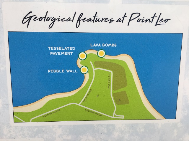
Point Leo Geological Features
The Mornington Peninsula region is an area featuring ancient 600 million year old Silurian sedimentary rock, 400 million year old Devonian granite outcrops, 60 million year old tertiary basalt platforms and more recent 2,600 year old Pliocene dune limestone. Much of the Point Leo area (including Phillip Island) was formed from lava flows that occurred in the tertiary period around 66 - 23 million years ago. These lava flows laid the basalt foundation for the Point Leo area as we know it today. Point Leo and the basalt coastline from Merricks to Cape Schanck have many features of geological significance. The Mornington Peninsula as we see it today was created at the end of the ice age about 12,000 years ago when port Phillip bay and western port were inundated by the rising sea.
The Mornington Peninsula consists of a number of fault lines, collectively referred to as the Mornington horst. These faults contributed to uplifts of the earths crust, the sinking of both Port Phillip and western port bay areas and the creation of the peninsula as we see it today. The largest of these faults is the Selwyn fault, which is still capable of producing earthquakes up to 7.5 in magnitude on the Richter scale. This fault extends 100 km from near cape Schanck all the way up to the Dandenong ranges. Other fault lines include the flinders, Tyabb, Balcombe and Devilbend faults.
Lava Fields - About 66 - 35 million years ago, molten magma flowed out of massive fissures to the north-west of Point Leo. This lava flowed over the former land surface filling in depressions and valleys creating vast basalt plains. These basalt plains formed over the south-western area of the peninsula. Erosion of the basalt along the coast has led to the formation of basalt shore platforms.
Lava Bombs - Scattered around the Point Leo area are large lumps of basalt called 'lava bomb'. These bombs form when large blobs of molten rock are thrown up during an eruption, falling back to earth to be embedded in a bed of volcanic ash that settles during the eruption. The ash eventually solidifies, protecting the lava bombs by encasing it in the soft rock. Years of erosion by wind and water have now exposed the lava bombs for us to see.
Basalt Pebble Wall - The basalt pebble wall is made up of ancient basalt pebbles, shells and other sediment, which could be up to 2500 years old. The wall formed duping a period when sea levels were much higher than they ape today. Sediment from the bay settled on top of the shells and pebbles on the beach. As the sea level receded the pebbles, shells and sediment solidified holding them in place.
Tessellated Pavement - When there is successive flows of magma over the earth's surface over a long period of time, the slow-cooling lava often fractures into vertically standing basalt columns. These columns are typically hexagonal in shape but can be four to eight-sided. The formation of these tessellated pavements can be seen along the rocky platforms of point Leo at low tide.
Cost:
A $4 per car parking fee is applicable if you are coming to Point Leo during the season. It is payable each Saturday and Sunday from 8 am to 4 pm between late September until the end of the Easter School holidays 2018, and every day over the summer school holidays.
Point Leo is an entirely self funded public reserve and receives no financial assistance from local, state or federal governments to manage 50 ha of public land. This includes the maintenance of five public toilet blocks, 4 kms of roads, two playgrounds, 25 ha of mown open parkland, the camping reserve and 3 kms of coast line. It is run by a volunteer Committee of Management. The only income to run the park is the money collected from parking and camping fees.
Review:
There is access to the beach from the cliff top park. There is a long wooden staircase running down to the beach. The beach is quite small and most of the beach has rocks all along the shoreline.
Photos:
Location
64 Western Parade, Point Leo 3916 View Map


")