Coronation Park Dog Off Leash Area (Healesville)

.jpg "Coronation Park Dog Off Leash Area (Healesville)")
Coronation Park has lots of areas to explore including grassy areas and bushland. At the car park, there is a shelter with two tables, BBQs, two unshaded tables, bin and water tap without a bowl.
There are some tracks throughout the area and generally the signage indicates where the off-leash areas are located.
Map of Off Leash Area:
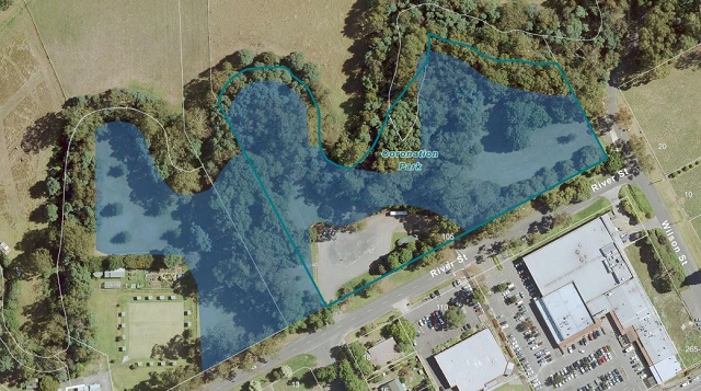
(Off leash area is shaded blue)
'The Markers'
-embed01.jpg)
North of the carpark are 'The Markers' which is a walk through 150 years of Healesville history.
The four Markers represent significant milestones in the establishment and growth of Healesville.
The Yarra Valley before 1894 - The Wurundjeri people and the arrival of European settlers.
Making Healesville - Gold, agriculture, settlement, timber and wine
Visiting Healesville - Tourism, rail, the environment, Healesville Sanctuary
Water - From the first inhabitants to the construction and significant role of Maroondah Dam
The Yarra Valley before 1894
Coranderrk - Coranderrk Aboriginal Station began on the banks of the Yarra River in 1863. Led by missionary John Green, his wife Mary, and elders Simon Wonga and William Barak, it became a successful, thriving, self-sufficient community. The station was gazetted at 4,850 acres and Healesville Sanctuary now sits at what would have been its approximate centre.
By the 1870s, the government wanted Coranderrk closed. A Royal Commission and a Parliamentary Enquiry were held, and the community showed political and personal strength by walking to Melbourne to make their case to remain at Coranderrk. Despite this, new laws were introduced, including the Half Caste Act which required all non full blooded aboriginal people to leave Coranderrk. This broke up families, removed all the working aged people and ultimately resulted in the official closure of Coranderrk in 1924, although a few families continued to live there.
In 1998, 200 acres of Coranderrk land was returned to the Wandoon Estate Aboriginal Corporation, and it now opens to the public for special events.
Cabbe melemung 'il - Before colonisation in 1788, the First People of Australia lived in all parts of the country. There were hundreds of different language groups and complex systems of trade, customs and beliefs.
The Yarra Valley was home to the Wurundjeri people of the Kulin Nation. The land and waterways provided them with abundant food, as well as materials for shelter, clothing and tools.
1834 - Following the establishment of Melbourne in 1834, European settlers spread across the countryside resulting in the decimation of aboriginal people through disease and battles, and leading to the establishment of missions and stations.
Making Healesville
Timber Cutting
'Where the timber-trucks come swinging down the curving hill-side track;
Where the splitter trudges singing with his weekly tucker pack;
Where the mountain ash is waving by the giant messmate tree - 'Spite the toiling, 'spite the slaving - that's the place where I would be.
Let me feel the pride of striving where the timbers crash and splinter..'
C J Dennis (1918) Backblock Ballads and Later Verses
Although timber cutters were working around Healesville from the early 1860s, it was not until the construction of the railway in 1889, that a viable industry was established.
In 1888 Thomas Crowley and his partner Patrick Fitzpatrick won the contract to supply sleepers for the extension of the railway from Yarra Flats (Yarra Glen) to Healesville. When the contract was completed, they established a mill at Chum Creek and by 1914 there were 12 independent mills in the area. Timber tram tracks laced the countryside, allowing the timber to be transported from the mills to the railway station.
By the 1920s, the timber industry was the major contributor to Healesville's economy. Mill owners and managers held important community roles and were significant supporters of fundraising events.
Production slowed in the 1930s due to timber strikes, economic depression and the 1939 bushfires which destroyed many mills. However the removal of burnt trees and the demand for pulp wood for paper making increased output again and the industry continued to grow.
During World War Two, petrol and rubber rationing meant that trucks delivered their loads to the railway station instead of Melbourne. Between 1941 and 1944, 68 million feet (20,726kms) of timber was transported out of Healesville by rail. By 1948, all the usable timber from the surrounding forests had been cut out, and the timber industry once again went into decline.
"In one instance I measured with a tape line one huge specimen that lay prostrate across a tributary of the Watts, and found it to be 435 ft (133 metres) from its root to the top of its trunk. At 5 feet (1.52 metres) from the ground it measures 18 feet (5.48 metres) in diameter... This tree has been much burnt by fire, and I fully believe that before it fell it must have been more than 500 ft (152.4 metres) high.." 21 February, 1872, the Inspector of State Forests, William Ferguson.
Heales'ville
Richard Heales (1821 -1864) arrived in Melbourne from London in 1842, and by 1847 he was working as a wheelwright and coach-builder. A passionate campaigner against alcohol consumption, he was also secretary of the Total Abstinence Society.
In 1850 Heales began his political career with his election to Melbourne City Council.
He then returned to England to work for the Temperance movement. When he came back to Melbourne 3 years later, he was appalled at the increase in alcoholism. This was due to the population explosion caused by the gold rush.
He re-established the abstinence societies and became President of the Temperance League. He also revived his political career, ultimately becoming Premier of Victoria in 1860-61.
In 1864, aged 42 Heales died from tuberculosis, leaving behind his wife, six sons and two daughters.
Heales was widely admired for his moral compassion and dedication to the improvement of the working classes and his funeral was attended by many.
In the late 1830s, European farmers and graziers discovered the rich soils of the river flats around what is now Healesville.They arrived from Britain, Scotland, Ireland and Switzerland and selected enormous tracts of land for cattle grazing. Many settled in the area, and their names survive as street and place names (Ryrie Street, Dalry Road, Dixon's Creek, Briarty Road, Bell and Armstrong Streets). Some of their properties still survive, including Gulf Station, Yering Station,Yeringberg,Tarrawarra Abbey and St Huberts, and although the vast land holdings have been sub-divided, their boundaries are still evident through fence lines and road alignments.
Grass & Grapes
In the late 1830s, European farmers and graziers discovered the rich soils of the river flats around what is now Healesville. They arrived from Britain, Scotland, Ireland and Switzerland and selected enormous tracts of land for cattle grazing. Many settled in the area, and their names survive as street and place names (Ryrie Street, Dalry Road, Dixon's Creek, Briarty Road, Bell and Armstrong Streets). Some of their properties still survive, including Gulf Station, Yering Station, Yeringberg, Tarrawarra Abbey and St Huberts, and although the vast land holdings have been sub-divided, their boundaries are still evident through fence lines and road alignments.
Some of these graziers and farmers also became winemakers.The first Yarra Valley vines were planted by the Ryrie brothers at Yering in 1838. They produced their first wine in 1845 and by the early 1860s the wine industry was flourishing. There were three main wineries; Yering (owned by Paul de Castella), St. Huberts (established by Hubert de Castella) and Yeringberg (established by Guillame de Pury). The wine industry continued to grow until the 1920s when the economic depression and changes in wine taste saw the end of the industry.
All vines were removed and the land was returned to pasture. It was not until the late 1960s that vineyards were replanted and wineries re-established.
Gold
The discovery of gold in the early 1860s resulted in thousands of people from around the world arriving in Australia to try their luck on the goldfields.
Woods Point was one of Victoria's most productive goldfields, accessed from Gippsland, or by the Yarra Track through Eltham, Christmas Hills, Yarra Glen, and up through the Black Spur. This later route led to the establishment of Healesville.
A small township initially emerged at New Chum (now Chum Creek) to supply goods and provide a resting place for travellers.
In 1863, the Yarra Track was improved and a new township was established on the high side of the Watts River. Healesville was gazetted in 1864, named after former Premier of Victoria, Richard Heales who died in the same year.
The first land auctions took place in 1865 and by 1866, more than 30 businesses had been established, including six hotels and a post office.
Visiting Healesville
Healesville has become a popular tourist destination since the 1860s. Inspired by the photographs of J W Lindt and Nicholas Caire, the first visitors came to see the lush fern gullies and cathedrals of mountain ash trees for themselves. They drove up Black Spur passing trees named Big Ben (a mountain ash) and Uncle Sam (a blackbutt) along the way.
Tourists Come to Town
From 1889, visitors could arrive by the new train line to stay in guesthouses ranging from small 2 room cottages to the impressive 60 room Gracedale House. Ironically the expansion of the timber industry gave visitors better access to the bush on trams originally built to transport timber from the mills to the railway station.
The Healesville Tourist and Progress Association was established in 1904 and by 1908 there were 25 guesthouses in Healesville. This figure exploded to 75 during the 1920s, the peak of guesthouse popularity. By the 1940s, the affordability of the car saw Healesville become a day trip destination. Guesthouses began to close, and today very few of these original dwellings survive.
The Rail Line
In 1889, the railway line was extended from Lilydale to Healesville and included an impressive 154.5 metre brick-lined tunnel through the hill between Tarrawarra and Healesville. The steam trains brought many visitors, including the Duke and Duchess of York in 1901.
They also increased productivity by transporting timber, livestock, milk and dairy between Healesville and Melbourne. The official train service closed in 1980 and tourist rides now operate from the Healesville Railway Station.
An Animal Sanctuary
In 1920, Dr Colin MacKenzie acquired 80 acres of Coranderrk Aboriginal Station and established the Institute of Anatomical Research. MacKenzie was a medical doctor but his later interest was in Australian fauna, which he began to study and collect extensively from 1919.
He published numerous papers and his collection became much sought after. In the 1920's his Healesville property was fenced and workshops and houses were built for curators and scientists. Now widely renowned as a tourist destination and research centre, Healesville Sanctuary opened as the Sir Colin MacKenzie Sanctuary in 1934.
Water
Melbourne's Drinking Water Supply
Five waterways, Watts River, Chum Creek, Donnelly's Creek, Badger (Coranderrk Creek) and Grace Burn all originally flowed untamed into theYarra River at Healesville.
These waterways have been significantly altered to allow for the catchment, containment and use of water by Melbourne's expanding population.
Graceburn Weir was the first to be constructed in 1876, followed by the construction of the Maroondah Aquaduct in 1886,which diverted water from the Watts River to the Preston Reservoir.
In 1891 the first Maroondah Reservoir was completed and two years later, Donnelly's Weir was built. This was followed by the construction of Badger Weir in 1909, which fed water to the Silvan Reservoir.
The existing Maroondah Dam was completed in 1927. Construction materials were transported in buckets along an aerial ropeway from the railway station to the dam site. 84 buckets carried 8 cubic feet of sand or cement, every 4 minutes for 6 years.
The ropeway passed over houses and electrical transmission lines, and no accidents were reported in the six years of its operation.
The Yarra River
The Yarra River begins on the slopes of Mount Baw Baw. According to an aboriginal creation story, Barwool wanted to release the Moorool or great water, which once covered the Yarra Valley. He used his stone axe to cut a channel but was blocked by Baw Baw. He tried in another direction, but was
stopped by Donna Buang and his brothers. He then turned to the west, and cut through the hills and met Yan-yan at Warrandyte. Yan-yan was trying to free Morang, the great water from his country, and together they cut a way through the hills. The Yarra River now follows the course the two men cut.
Photos:
Location
105 River Street, Healesville 3777 Map
Web Links
→ Coronation Park Dog Off Leash Area Map (PDF)
")


")