Maldon - Anzac Hill Walk


Anzac Hill Walk is a scenic 2 km walk with views of the township of Maldon and historical facts. It has points of historical interest and is an uphill climb which takes 60 minutes minimum.
The walking track leaves Spring Street. approximately 170m from High Street.
Map of Anzac Hill Walk (Maldon)
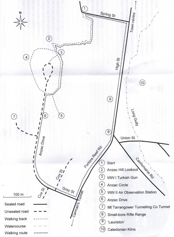
(1) - look for, the white gravel path leading up the hill. The steepest section of the walk is between here and the lookout point (2), a climb of about 50m over a distance of 300m. Beyond the lookout point the track passes the WW I Turkish gun (3) and becomes part of Anzac Circle (4). This then connects with Anzac Drive (6).

Take the side track shown on the map to visit the location of the VVW II Air Observation Station (5.) Continue down Anzac Drive - the circle and drive were planted in 1916 and the name of a killed serviceman is associated with each tree. A path leading off to the right from the avenue leads to the Mt Tarrangower Tunnelling Company tunnel (7.) This tunnel was commenced in 1865 and was extended 300m into the hill before being abandoned in 1869 without yielding significant gold. The first rock drill used in Australia was introduced by this company in 1868.

Continue down Anzac Drive and turn left at Parkins Reef Road. From here Spring St. is about 700m. At the intersection of High St. and Castlemaine Rd., the site of the former small-bore rifle range (8) can be seen on the left. Further along High St. the second house, 'Lauriston' (9), was the home of Robert Dent Oswald, possibly the most successful operator in the gold mining history of Maldon. A further 50m along on the eastern side of High St, are the remains of Oswald's crushing plant and the Caledonian quartz kilns (10.)

Anzac Hill Memorial Tree Planting
In May 1916, the Maldon Progress Association was re-formed to improve the surroundings of the town as well as to plant trees in memory of Pioneers, Maldon residents and some of the Maldon soldiers killed in WW1. They decided to re-name Garfield's Hill "Anzac Hill" and to set aside approximately 21 acres as a reserve. Families paid for a wooden tree guard which enabled a tree to be planted in memory of the person or family they nominated. In June 1916, a plan was drawn up which had three sections of planted trees:
Anzac Avenue - a zig-zag pedestrian track from Spring Street upwards. This was to be in honour of residents, families and pioneers of Maldon and District.
Anzac Drive - a carriage or motor track upwards from Parkin's Reef Road, also for residents and pioneers.
Anzac Circle - a circle of 32 trees linking the two tracks. Later this was doubled and the two circles commemorated WW1 soldiers who had died or been killed in action.
Of the approximately 470 men and women from Maldon and District who had served, around 80 died, with 60 of them honoured on Anzac Hill. In 2018, more than 100 years on, Anzac Circle was replanted by Maldon Urban Landcare. This time, the trees were the more hardy local Yellow Gums. Sadly, quite a few were impacted by dry conditions and further replanting was required in 2019. Anzac Hill is a special place where all of these soldiers can be remembered and their sacrifice recognised.
(Courtesy Maldon Museum & Archives)
Review:
An interesting walk with an Anzac theme, diversion to a tunnel from the gold mining days (there are bars across the tunnel to stop access into the tunnel) and the remains of a crushing plant and quartz kilns.
Photos:
Location
Spring Street, Maldon 3463 View Map


")