Manangatang Heritage Walk


Manangatang is a small Victorian town with a population of some 300 residents and another 200 in the outlying farms. It is situated 85km west of Swan Hill and equal distance from Ouyen, Robinvale and Sea Lake in the heart of the Mallee. The Manangatang township is surrounded by thousands of hectares of cereal crops which produce the highest quality wheat, barley and legumes. Properties are stocked with cattle, pigs, emus and sheep.
Manangatang is said to come from an Aboriginal word Manang meaning "land" and Kaatin meaning "water". Together the words may signify "claypan" or "water reserve" as used in the past by early Government officials working in the area. The waterhole lies on the line of an old track, which is said to be used by wild animals, Aboriginal people, and later by squatter's men.
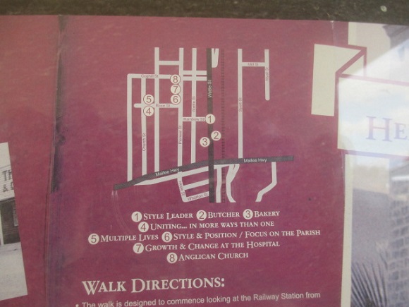
The Manangatang Heritage Walk is designed to commence looking at the Railway Station from near the Traveller's Rest.
Walk southwards along Wattle Street to the Butcher's shop.
Opposite is the "Baker and Pastrycook"
Walk northwards along Wattle Street to the Hotel corner. Walk along Rainbow Street to Pioneer Street. Take the dog leg to Rose Street.
On the corner of Church and Rose Street is the Uniting Church, with the Masonic Lodge opposite (Rose Street)
Walk to the corner of Pioneer and Rose, then along Pioneer where you will see the Catholic Presbytery, the Catholic Church, the Hospital and lastly St Andrews Anglican Church.
Turn eastwards along Coghill Street towards the Police Station and the big silo. Walk southwards along Wattle Street, past the Hall and shops, towards the crossroads.
Map of Walk:
Photos:
Location
51 Wattle Street, Manangatang 3546 Map
")


")