Euroa - Walking Trails


The Strathbogie Shire, local Landcare groups and the Strathbogie Ranges Conservation Management Network has documented a number of local walks.
Balmattum Hill Walking Trail, Euroa
Clear route markers are placed along the track for both short and long walks. The Balmattum Hill Walking Track links with the Seven Creeks Walking Track, or Apex Track
Short walk - The track from the car park to the rotunda is about 300 m long, offering a pleasant walk with valley views. Along the track, extensive revegetation using native plant species has helped prevent soil erosion and create better habitats for wildlife, and it has made the area more attractive.
Long walk - From the rotunda, the track rises steeply (about 170 m of incline) for about 1 km and ends near the summit of Balmattum Hill. The track offers views over Euroa township and across the vast Victorian northern plains as far as the eye can see. Rather spectacular! The track passes a rock stack, showing where during World War II soldiers physically trained by carrying rocks up the hill. These rocks remain along the track side.
Distance:
Short walk - 600 m return
Long walk - 2 km return
Total - 2.6 km return
Relative difficulty:
Short walk - easy
Long walk - moderate
Location:
175 Euroa-Strathbogie Road, Euroa
Travel south along the Euroa-Strathbogie Road from the intersection of Tarcombe Street and the Euroa-Strathbogie Road (Templeton Street). This intersection is signposted to Strathbogie. After 1.75 km turn left at the Balmattum Hill Walking Track sign, and continue for 120 m to the car park.
Seven Creeks Walking Trail, Euroa
Distance: Total distance is 7 km. Several bridges crossing the Seven Creeks can be used as alternative routes.
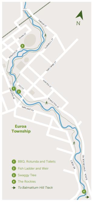
Location - East end of Bury Street, near the BBQ, rotunda and public toilet buildings which is next to the Euroa Museum. You can also choose to start the walk anywhere along the Sevens Creek.
Short walk - 3 km circuit to the north (downstream)
Long walk - 4 km circuit to the south (upstream)
Relative difficulty: Easy
The walking track follows the Seven Creeks as it passes through floodplain riparian woodlands. The track surface ranges from well maintained asphalt and grassed areas to loose gravel.
At the southern end, the Seven Creeks Walking Track links with the Balmattum Hill Walking Track. A multipurpose track offering nature's delights to enjoy!
Track Notes
The Seven Creeks Walking Track is set in the Euroa Seven Creeks Reserve which supports passive and active recreation pursuits. The majority of the formal sporting facilities utilised by the Euroa community and visitors are located within the reserve.
The Seven Creeks Reserve is situated on a natural floodplain and is largely made up of two types of vegetation communities, Floodplain Riparian Woodland and Plains Grassy Woodland. The dominant trees are River Red Gum (Eucalyptus camaldulensis) providing hollows and canopy for habitat. Silver Wattle and Blackwood providing nectar when in flower and there is a ground cover of grasses, herbs (non-woody small plants), fallen branches, twigs and leaves. The variety of habitats attract a range of fauna, such as microbats, possums, gliders, koalas, echidnas, snakes, blue tonged lizards, geckos and skinks.
Regular bird surveys have been conducted recording over ninety different bird species. Granite boulders can be found along the creek towards the southern section of the reserve. The creek bed can change as a result of soil from the banks eroding due to fluctuating water levels and water flow velocity creating backwater billabongs and deposits of sediments forming sand bars and sand slugs. The creek supports habitat for aquatic species such as native and exotic fish, water rats, platypus, and frogs. A fish ladder is installed, adjacent to the weir, enabling fish to swim up and down the stream for breeding as part of their natural life cycle.
Seven Creeks Reserve is both culturally and historically significant. Located in the reserve is a local natural icon, a large River Red Gum tree some hundreds of years old, locally named the Swaggy Tree. During the Depression of the 1930s it is believed those in need took shelter here. Major Thomas Mitchell passed nearby in 1836 when undertaking the "Australia Felix" expedition and, not long after, the township of Euroa was established on the banks of the Seven Creeks.

Long-term residents have memories and stories of the area that describe mining and gypsy camps, humpies, Chinese market gardens, old river crossings and deep swimming pools. Until the Olympic Pool was built in 1970 the pool below Burton's Bridge was the town's main swimming area, complete with pavilion, changing rooms, diving boards and learner pools.
Access for Dogs:
Dogs are permitted on-leash.
Web Links
→ Walk Notes - Balmattum Hill Walking Trail, Euroa (PDF)
→ Walk Notes - Seven Creeks Walking Trail, Euroa (PDF)
")


")