Pelican Point Beach (Mount Eliza)

.jpg "Pelican Point Beach (Mount Eliza)")
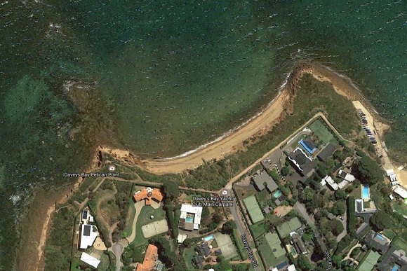
At Pelican Point, the coast turns east into Daveys Bay, then swings back to face west past Kackeraboite Creek. This 1.5 km long section is dominated by 20 to 30 m high bluffs, rocks and reefs. The narrow, 200m long Pelican Point Beach is at the southern end of this section.
There are also steps down to Pelican Point Beach at the end of Daveys Bay Road.
There is a walk along the cliff top. If you turn to the right you will walk around to Davey's Bay. Turn to the left and you will come to Pelican Point Lookout (currently closed off due to a landslip) and then on around to Freemans Road. Directly at the end of Davey's Bay Road are steps that take you down to Pelican Point beach.
Swimming - A relatively safe beach during light winds and low waves. However, strong westerlies and accompanying waves will produce strong rip currents.
Review:
From the end of Daveys Bay Road, a wooden staircase (about 60 steps) leads down to a narrow, crescent shaped beach which has cliffs backing onto it. There are rocks at each end of the beach and it looks like the water gets deepish rather quickly. The beach is scattered with little stones and rocks.
Map:
Photos:
Location
31 Daveys Bay Road, Mount Eliza 3930 Map
Web Links
→ Pelican Point Beach (BeachSafe)
")


")