Graytown - Heathcote-Graytown National Park


Heathcote-Graytown National Park is a great place for bushwalks. Mt Ida, Mt Black and Viewing Rock provide views of Heathcote and surrounding areas.
The park also has a rich history with relics from the gold rush and war era to discover at Graytown. Melvilles Lookout is a prominent ridge where Captain Melville reputably waited in ambush for miners during the gold rush. Explore gold rush and war era historic features, or simply enjoy the solitude of the Box-Ironbark bush.
Melvilles Lookout has basic picnic facilities. If an overnight stay is more your style, pitch a tent at the Dargile camping and picnic area and wake up to a choir of birds.
History
Aboriginal association with Box-Ironbark forests dates back many thousands of years. The forests provided food, material for tools and shelter. The close association with the forests continues today and significant Aboriginal sites can be found throughout the area.
The historic gold rush town of Graytown once attracted thousands of diggers. Streets, building foundations and a cemetery are evidence of the former township.
Relics of a Second World War prisoner-of-war camp can be found near the former township of Graytown. Mt Black is the highest point in the area. It was once a quarry source for the Goulburn Weir near Nagambie, including the significant Bailieston Track charcoal pit.
Melvilles Lookout is a prominent ridge where Captain Melville reputably waited in ambush for miners during the gold rush.
The 12,833ha Heathcote-Graytown National Park was proclaimed with the passing of the Box-Ironbark Bill in October 2002.
Facilities and Accommodation
Camping is available in the Dargile Picnic and Camping Ground where there are basic pit toilets and shelter facilities. You will need to provide your own drinking water. Camping is also available at Spring Creek where only very basic facilities are provided.
Motels, B&Bs and caravan parks are located in the nearby towns of Heathcote and Nagambie.
Other interesting places to visit
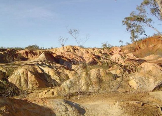
Pink Cliffs
This interesting and colourful phenomenon was created by early gold-mining activities. Sluicing work was carried out until the early 1880s and it was in this period that work in the Pink Cliffs area brought to light these colourful "hills".
From the Northern Highway, follow Jennings Street to the west, turn south onto Hospital Street, then west onto Pink Cliffs Road and follow directional signs.
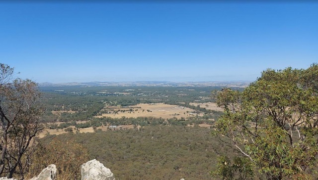
Viewing Rock
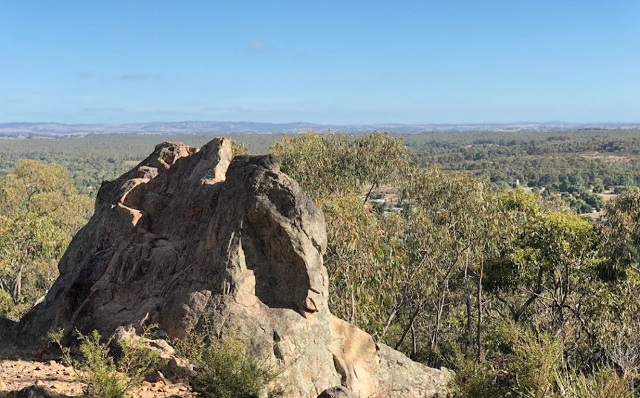
From here you can take in a fantastic view of Heathcote, which is reputed to have the longest main street in the southern hemisphere. Take a hike down to the Powder Magazine, witness a spectacular array of orchids, or just sit and listen to the harmony of the Grey Shrike Thrush.
Heading north along the Northern Highway turn east onto Chauncey Street, drive past the Showgrounds and follow the bitumen road around to the left. Then turn right onto Range Drive and follow the signs to Viewing Rock.
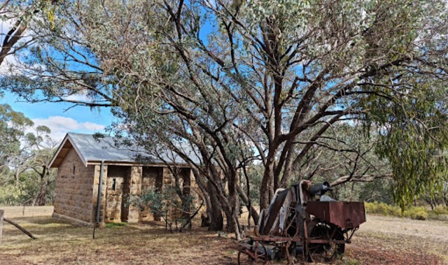
Heathcote Powder Magazine
This English style masonry brick building was used in the 1860s to house gunpowder and explosives for the McIvor Diggings Gold Rush. Powder magazines were located away from residential areas in case of accidental explosion.
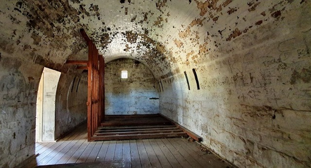
There is an information panel which reads "The Heathcote Powder Magazine was constructed by the Public Works Department in 1864, from high quality locally quarried stone. The builder was H. Cormack & Co. In Victoria, powder magazines stored explosives used in gold mining, quarrying and road making, and were located outside many goldfields towns to avoid accidental explosions close to residential areas. This powder magazine features a brick vaulted space inside a buttressed rectangular building, with a small entry and office space. The vault, buttressing, and baffled air vents were a result of the belief at the time that extensive masonry would help to contain explosives. The gabled roof was originally of slate. Sawn Oregon racks remain in the main room, together with a two-door iron safe with decorative stencilling. The building demonstrates particularly fine stone masonry and brick vaulting work, and is a excellent example of a Public Works Department designed powder magazine."
Simply follow Barrack Road to the East (off the Northern Highway), turn right before the caravan park into Forest Drive and follow the directional signs.
Beside the parking area there is a picnic table. The Viewing Rock Circuit Walk, which is a one hour return track which takes you past Devils Cave and Viewing Rock lookout, begins from here.
Mt Ida
Imagine you are sitting on the top of the world where Victoria's remaining Box-Ironbark forests disappear into the hazy horizon in all directions. Views from Mt Ida will inspire even the hardest to please outdoor enthusiast.
From Heathcote, turn right towards Echuca and drive north on the B75 (Northern Highway) for 4km, you will see Mt Ida Road, turn right onto Mount Ida Tower Road and follow this track for about 2km, at the back of some properties. Where the track turns sharply right and uphill, you can park your vehicle in the short side-track.
This walk is about 5 km with medium - steep sections and rocky ground. It will take about 2 hours, so carry water with you. In early spring, the wildflower display in this area can be sensational.
To begin your walk, go uphill along Mt Ida Tower Rd road until you see a track heading north signed Management Vehicles Only. Follow this track (Unnamed Track 82) until you come to a track heading off to the right (Unnamed Track 80). This track heads uphill and eventually joins the Mt Ida Tower Road just short of the summit.
After enjoying the views from the summit you can retrace your steps for about a kilometre until you reach a track heading downhill and to the right. The intersection is marked with a number of cairns. Turn left to return to your car, or right, if you wish to do the Dargile Forest Walk.
Access for Dogs:
Dogs are only permitted in the McIvor Range area (marked on the map) and must be kept on a leash at all times.
How to get there
Heathcote-Graytown National Park is 110km north of Melbourne via the Hume Highway.
Vehicles, including motor bikes, may only be used on formed open roads. Drivers must be licensed and vehicles registered and roadworthy.
Location
Heathcote-Nagambie Road, Graytown 3608 View Map
Web Links
→ Heathcote-Graytown National Park (Parks Victoria)
→ Heathcote-Graytown National Park Map (PDF)
→ Heathcote-Graytown National Park - Park note (PDF)


")