Alpine Shire Walks (Mount Beauty, Tawonga, Bogong Village)

There are a variety of walks in the Alpine Shire
Mount Beauty Walks
Pondage Walk
3km, 45 mins return
No bushwalking experience required. Well-formed, flat track with no steps. Clearly sign posted.
Start from the Lakeside picnic and playground area and walk north towards Embankment Drive following the path around the pondage wall. Follow the track over the spillway and continue along over the Tail Race Channel bridge and you will be behind the Secondary College, the tennis courts, the Primary School, past the oval and back to where you started. A pleasant walk with lovely views in all directions.
Mermaid Pool & Rock Pool
1.2km, 20 mins return
No bushwalking experience required. Well-formed track with no steps and gentle hills.
Take the first road to the right off Damms Road (Rock Pool Road) and continue until reaching the car park. Walk the bush track 250 metres into the Mermaid Pool, a beautiful
swimming hole ideal for families, and continue along the track another 400 metres to the Rock Pool. Return the same way or follow the track along the river from the Mermaid Pool.
Survey Track/Pole Track
4.5km, 2 hrs return
No bushwalking experience required. Formed track with some obstacles, short steep hills and occasional steps. Sign posted.
The Survey Track is a shared walking and mountain bike track that commences opposite the Mount Beauty Golf Course Club House in Tawonga Crescent. Park at the top of Tawonga Crescent or at the Big Hill Mountain Bike Park, if doing the full loop that includes the Pole Track.
The Survey Track is the original route to Bogong Village and provides views over the east branch of the Kiewa River as it winds upwards, through dry forest and areas of wildflowers to a hairpin turn on the Bogong High Plains Road called 'Cranky Charlie'. A couple of fire trails have to be crossed, look for the restart of the track on the other side.
On reaching Cranky Charlie either return the way you came, or cross the Bogong High Plains Road and walk up West Kiewa Road for approximately 500m to where the Pole Track branches off to the right. Pass through the gate and descend back down to Mount Beauty to a second gate then join the Aqueduct Track to return to the Big Hill Mountain Bike Park.
This return route offers great views over Mount Beauty and the Kiewa Valley. The track may also be done in reverse, along the Pole Track from the Big Hill Mountain Bike Park, turning around when you have had enough. This scenic route is a shorter alternative to the full loop.
Mount Beauty River Walk
4km, 1 hr return
No bushwalking experience required. Flat well-formed track with no steps. Clearly sign posted.
The track starts at the commencement of Embankment Drive off the Bogong High Plains Road at the entrance to Mount Beauty. This sealed track crosses the Pondage spillway and then meanders along the west branch of the Kiewa River all the way to Pebble Beach.
Enjoy lovely views across the farmlands and towards Mount Bogong with the track perfect for walking or riding. For good swimmers, there is a long deep pool at the turn around point.
Mount Beauty Gorge Walk
2.8km, 1.5hrs return
No bushwalking experience required. Formed track with some obstacles, short steep hills and occasional steps. Sign posted.
Start the walks from the Big Hill Mountain Bike Park, off the Bogong High Plains Road on the right side, heading towards Falls Creek. Walk uphill along the Aqueduct Track behind the large holiday apartments, follow the signposted track for 1km to a swing bridge over the West Kiewa River. To get to the adit/shaft and the canyon, plus get great views of the Gorge, cross over the swing bridge and walk uphill, you will come across a swimming hole and another 100m up the river.
The adit was dug in the 1950's to help with the construction of the Kiewa Scheme. During summer, when the rocks are dry in the river bed, it is possible to walk, wade and swim upstream for 400 metres to an impressive canyon. It is not advisable to do this last section if the rocks are wet and slippery. The last section of the canyon is best attempted in the late afternoon when the sun shines on the water.
Tawonga Walks
Mount Beauty to Tawonga Walk
13.4km, 3hrs return
No bushwalking experience required. Well-formed track with no steps and gentle hills.
This walk connects Mount Beauty, Tawonga South and Tawonga passing a lookout which provides impressive views across the Kiewa River valley to Victoria's highest peak, Mount Bogong (1986m). This walk can be started at any point between Mount Beauty and Tawonga.
Fisherman's Walk
1km, 40 mins return
No bushwalking experience required. Well-formed, flat track with no steps. Clearly sign posted.
Start at the picnic ground next to Ryders Bridge. The walk takes you south alongside the Kiewa River towards Mount Beauty. This area is popular with locals for swimming during the warmer months. Located 100 metres from the bridge along the riverbend is a fantastic swimming hole.
Ryders Lane Walk
2.5km, 50mins return
No bushwalking experience required. Well-formed track with gentle hills and no steps. Clearly sign posted.
This walk connects the Mount Beauty to Tawonga Walk to the Fisherman's Walk via Ryders Lane. Turn onto Ryders Lane from the Kiewa Valley Highway and walk down to the picnic ground on the Kiewa River at Ryders Bridge.
Bogong Village Walks
Lake Guy Walk
3km, 1-1.5hrs return
No bushwalking experience required. Formed track with some obstacles, gentle hills and many steps. Sign posted.
Park in the car park just below Bogong Jacks Tavern. The track around Lake Guy starts 150 metres northwest of the car park. Continue through the tunnel in the dam wall and follow the walking track to 'The Junction' at the confluence of the Rocky Valley and Pretty Valley
Stream which then flow into Lake Guy (Junction Dam). Return past the new power station, either above it on the road, or below on the walking track beside the lake.
Fainter Falls
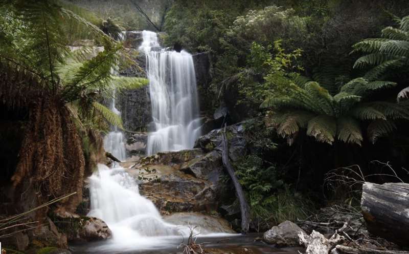
1.5km, 40 mins return
No bushwalking experience required. Formed track with hills and no steps. Clearly sign posted.
This walk is located 1km past Bogong Village (in the direction of Falls Creek), just before the Bogong High Plains Road crosses the Pretty Valley Stream. Start the walk opposite the car park. Follow the signed walking track, which provides spectacular views of the falls and the beautiful environment beside the wild river.
The track follows the course of a wild river - the Pretty Valley Branch of the East Kiewa River. Along the way you travel through a variety of vegetation from dry forest, through moist gullies, past towering eucalypts and alongside tree ferns. The walk climbs on a relatively easy grade to a viewing point with a birds-eye view of the river and then onto the Fainter Falls lookout. Both can be reached without encountering any steps. For the more adventurous, a short (200m) but steep section of track takes you to a lookout below the falls.
The Pretty Valley branch of the East Kiewa River has experienced many changes in the last 50 years. The Kiewa Hydro-Electricity Scheme, created in the early 1940s, stores water on the Bogong High Plains for for release through a series of power stations. Whenever peak load power is needed in Victoria, water is automatically released and passes through the electricity-generating turbines in the McKay Creek Power Station. This water then discharged directly into this section of river causing large fluctuations in the flow. The energy of the discharge water was wasted and the ecology of the stream was altered. In 2009 this system changed with the construction of a new downstream power station at Bogong Village. Water is now channelled directly from one power station to another by a 5m diameter tunnel located some 200m ft below. The river will return to more natural flows, more to the liking of fish, aquatic insects and anglers.
Fainter Falls continues to flow for the whole year. The water comes from high above in the Mt Fainter area. Winter snowfalls and seasonal rains recharge the groundwater, springs and alpine wetlands which slowly and continually release the water along Fainter Creek. Many creeks like this one channel the water during the summer months from the alpine peaks and plains and contribute significant amounts of water to the river systems.
Mountain Creek Walks
The walks start from the Mountain Creek Picnic and Camping Area, 10.5 km along Mountain Creek Road from the Kiewa Valley Highway, Tawonga. Nestled at the base of Mount Bogong (1986m) there are several walks ranging on length, through cool moist fern-filled gullies or among drier peppermint forests on the slopes.
Mountain Creek Picnic and Camping Area is also the starting point for the most popular routes up Mount Bogong, the Staircase and the Eskdale Spur.
Shady Gully Nature Walk
1km, 15mins return
No bushwalking experience required. Well-formed track with no steps and gentle hills. Sign posted.
Starting south of the main bridge, this is an easy loop walk that provides you with a taste of the riparian forest of this area. Follow Mountain Creek which has its headwaters on nearby Mount Bogong and then cross back to complete the loop.
Tree Fern Walk
2km, 1hr return
No bushwalking experience required. Well-formed track with no steps and gentle hills. Sign posted.
This track starts north of the bridge and is a gentle meander along Mountain Creek. The track is well defined and if you would like a longer walk you can take the turn off to the Black Cockatoo Walk.
Black Cockatoo Walk
2.5km, 1.5hrs
No bushwalking experience required. Well-formed track with no steps and gentle hills. Sign posted.
This track starts along Mountain Creek Road, past the picnic area (4WD), or can be combined with the Tree Fern Walk to create a longer loop along the banks of Mountain Creek
Peppermint Walk
2.5km, 1.5hrs return
No bushwalking experience required, formed track with some obstacles, short steep hills and many steps. Clearly sign posted.
The Peppermint Walk starts in the picnic area and heads off along Mountain Creek Road (4WD). After 1km, turn south and follow the track as the vegetation changes from tree ferns, sedges and tussock grasses to peppermint and blue gum forests. This is a great walk for a hot summer's day.
Fainter Falls Photo Credit: Shaun Smith
Web Links
→ Fainter Falls Walk (Parks Victoria)
")


")