Wangandary - Warby-Ovens National Park


The 14,655 ha Warby-Ovens National Park is characterised by three distinct vegetation communities - the granitic hills and woodlands of the Warby Range, the Box-Ironbark of the Killawarra Forest and the Redgum forest and wetlands of the unregulated Ovens Heritage River.
Enjoying the Park
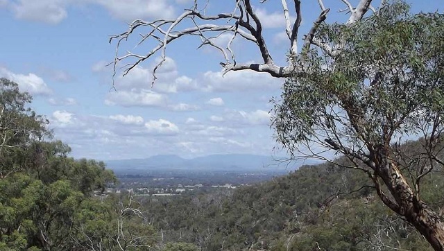
The views from Ryan's Lookout are exceptional, especially in winter with snow covered peaks in the distance.
Picnicking
Ryan's Lookout, Brien's Gorge Falls, Pine Gully and The Forest Camp have barbecue facilities and picnic tables.
Bike riding
Bike riding is permitted on open vehicle roads tracks and some management tracks including Pangarang Lookout Walk and Ridge Track to Mount Glenrowan. Riding is prohibited on all other walking tracks and areas affected by Cinnamon Fungus.
The Friends Walking Track may be used by both walkers and bike riders between the hours of 6pm and 11pm Monday to Sunday and 8am to 12 noon on Saturday and Sunday. Bike riders must give way to walkers and remain on the tracks at all times.
Car touring
For a pleasant drive, follow Gerrett's Road from Ryan's Lookout, turn right into Adam's Road, then follow Tower Road to Boweya Road and return to Wangaratta. To visit the Killawarra Forest enter via Camp Road from Boweya Road turn right into Center Road, re‐join Boweya Road via School House
Road.
Walking
The Warby Ranges and Killawarra Forest offer a variety of walks along designated tracks, ranging in length and difficulty. There are no defined walking tracks along the Ovens River, but visitors can explore the River Red Gum forests by following the vehicle tracks and riverbanks. Management tracks are ideal for easy walking. A GPS or topographic map and compass is recommended.
Friends Track - 4.6km loop, 2hrs - Grade 3
A self-guided walk starting from Wenhams Camp. There is an opportunity to divert from the track to Kwat Kwat Lookout (1km return) with excellent views of the Ovens Valley and the Victorian Alps. Mountain bike riders are permitted to use this track so look out for cyclists.
Alpine Views Walk - 2km one-way, 2hrs - Grade 3
Expansive views of the Alps can be enjoyed on a clear day. The track is also rich in orchids and other wildflowers in spring. The walk initially follows the Friends Track south east from Wenhams Camp and ends at Boilerwood Track. The track is steep in places and a moderate level of fitness is required.
Chick Hill Walk - 1km one-way, 1hr - Grade 4
A very steep climb from the corner of Wirrinya Avenue and Taffe Road in Hamilton Park rewards walkers with spectacular views of the Alps, including Mt Buffalo. The track also links up with the Ridge Track leading to Mt Glenrowan. The track is very steep with limited signage. Moderate fitness is required.
The Friends of the Warbys Arboretum - A walk through the Arboretum at Wenhams Camp helps visitors identify the park's diverse range of plants.
Salisbury Falls Walk - 4.5km one-way, 2hrs - Grade 4
Starting from Shanley Street, this track makes its way up Mt Warby and on through the Salisbury Falls Gorge before joining the Friends Track to Wenhams Camp. The track is steep in places with many stairs and a moderate level of fitness is required. It can be walked in reverse, or combined with the Alpine Views Track.
Salisbury Falls
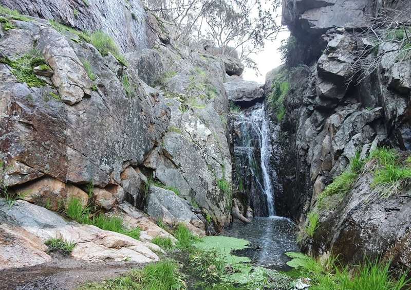
From the small parking area at the end of Shanley Street, there is an easy 800m walk along a well-defined track to get viewing access to the falls. The waterfall is only active after heavy rain.
Sunrise Walking Tracks - 2-6km loop, 1hr-3hrs - Grade 3
This complex of walking tracks offers multiple options and loops ranging from two to six kilometres and from moderate to hard. During spring a variety of wildflowers can be seen here. Look out for Turquoise parrots too. The walks start at Sunrise Carpark at the end of Delloro Road. Some of the tracks are steep in places with many steps. A reasonable level of fitness and bushwalking experience is recommended.
Taylors Track and Peregrine Track - 1.7km one-way, 30mins - Grade 2
This walk leads to Kwat Kwat Lookout for excellent views of the Ovens Valley and the Victorian Alps. It provides a more direct route to the lookout from Wenhams Camp and can be used as diversion or shortcut from the Friends Track. This formed track has a mostly gentle gradient until the last 50 metres where it becomes steeper, and a few obstacles.
Springtime Flower Walk - 4.9km loop, 2.5hrs - Grade 2
This easy loop walk is a lovely family stroll through Box Ironbark forest rich in birdlife. In spring, wildflowers cover the forest floor. The track is relatively flat and well signed. Starting at Forest Camp, you can take the shorter northern loop (1.2km, 30mins) or the longer southern loop (3.7km, 2hrs) or combine them both.
Pangarang Lookout Walk - 4.5km return, 2hrs - Grade 3
This easy walk offers panoramic views to the west over farmland and floodplain. It begins from the carpark on Ferris Road and follows the Management Vehicles Only track to the lookout. The formed track has a gentle slope with some low obstacles, becoming moderately steep towards the end. Return the same way. Mountain bikes are permitted on this track.
Pine Gully Nature Trail - 2km loop, 1hr - Grade 3
This self-guided walk introduces visitors to the park's natural values and is an excellent place to appreciate the wildflowers in spring. After sufficient rain, the Pine Gully Falls can be seen from the viewing platform. It is steep and rocky in places and can be slippery.
Warby Falls Heritage Trail - 3.2km one-way, 2hrs / 7.4km loop, 5hrs - Grade 4
From the carpark on Booth Road, this track follows a gully with a historic saw mill, weirs, sheep washes, dams and waterfalls (dry in summer). It ends at the carpark near the corner of Booth Road and Baileys Road, next to the Taminick Winery. The gradient is gentle at the beginning and end, but steep in the middle, with multiple obstacles and undulating terrain. A high level of fitness is required.
Mt Glenrowan Lookout Walk - 9km return, 4hrs - Grade 3
Morgans Lookout on Mt Glenrowan offers unparalleled views of the Ovens and King Valleys and the Victorian Alps. The walk begins at Taminick Gap. Park on the dirt carpark on the side of the Ridge Track, before the gate. The first section is a short steep climb up the sealed road to the communication towers. With the hardest climb behind you, the rest of the walk is moderate to easy. Mountain bikes are also permitted on this track.

Camping
There are campgrounds at Wenhams Camp and The Forest Camp. No bookings, no fees.
More adventurous campers will enjoy camping on the banks of the Lower Ovens River. No facilities are provided and tracks can become impassable in wet weather.
Fishing
Murray Cod are frequently caught in the Lower Ovens River. Most are returned to the river to ensure the ongoing survival of this iconic fish.
Boating
The lower reaches of the Ovens River offer some of the best still water canoeing in the state among a maze of channels and wetlands. With care power boats can explore the river for several kilometres upstream from Camerons Bend.
Prospecting
Prospecting is permitted in a small area in the Killawarra section of the park ‐ 200 metres either side of Tarrawalla Track (between Boweya Track and a point 200 metres past the junction of the adjoining Parallel track). Prospectors may only search for gemstones, in particular the mineral Wavelite. Prospectors must hold a Miners Right or Tourist Fossicking Authority.
Horse riding
Horse riding is allowed on vehicle tracks throughout the park. No horses are permitted on walking tracks.
Briens Gorge
Enjoy a picnic or barbecue at Briens Gorge. There are also barbecue facilities and picnic tables at Ryans Lookout, Pine Gully Picnic Area and Adams/Tower Road.
Camerons Bend
The lower reaches of the Ovens River offer some of the best still water canoeing in the state among a maze of channels and wetlands. With care, power boats can explore the river for several kilometres upstream from Camerons Bend.
Pine Gully Picnic Area
Enjoy a picnic or barbecue at Pine Gully Picnic Area. There are pit toilets here. There are also barbecue facilities and picnic tables at Briens Gorge, Ryans Lookout and Adams/Tower Road. There are no stores or kiosks around the park.
Ryans Lookout
The views from Ryan's Lookout are exceptional, especially in winter with snow covered peaks in the distance. Enjoy a picnic or barbecue at Ryans Lookout. There are also barbecue facilities and picnic tables at Briens Gorge, Pine Gully Picnic Area and Adams/Tower Road.
For a pleasant drive, from Ryan's Lookout follow Gerrett's Road, turn right into Adam's Road, then follow Tower Road to Boweya Road and return to Wangaratta. To visit the Killawarra Forest enter via Camp Road from Boweya Road turn right into Center Road, re-join Boweya Road via School House Road.
Access for Dogs:
Dogs and other pets are not permitted in the park.
How to get there
Warby‐Ovens National Park is 240km north east of Melbourne and 10km west of Wangaratta. It is best accessed from Wangaratta via Wangandary and Yarrawonga Roads.
(Photos by Parks Victoria)
Location
Warby-Ovens National Park, Wangandary Road, Wangandary 3678 Map
Web Links
→ Warby-Ovens National Park (Parks Victoria)
→ Warby-Ovens National Park - Park note (PDF)
→ Warby-Ovens National Park - Visitor Guide (PDF)
")


")