Two Bays Walking Trail (Dromana - Cape Schanck)

The Two Bays Walking Track is one of the longest continuous walking track on the Mornington Peninsula. It stretches 26km through a diverse range of Mornington Peninsula landscape. The whole walk can be completed in a day for walking enthusiasts, or split up into multiple smaller walks for those who want to enjoy it in smaller sections. The Two Bays Walking Track is identified by a circular symbol displaying a Blue Wren, which can be seen on signage along the track.
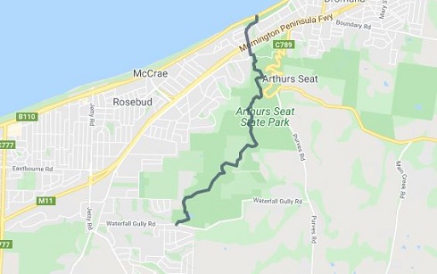
Start in McCrae on Point Nepean Road and walk up the steep staircase to the top of the cliff and onto Latrobe Parade. Follow the road over the freeway and into Bunurong Track. This is the start of the Arthurs Seat State Park. The winding track climbs the hillside to Seawinds Garden. The track continues past the adjoining Kings Falls Track and leaves the State Park at Waterfall Gully Road.
The track continues through local streets and a small reserve to Browns Road. Follow the blue wren symbols on the power poles within this section to navigate. The track then crosses Browns Road into Hyslops Road where it joins the Mornington Peninsula National Park section known as Greens Bush.
Crossing small creeks and walking alongside Main Creek the track then crosses Boneo Road and passes Bushrangers Bay on its way to Cape Schanck.
The grade and surface of the track varies from steep gravel sections around Arthurs Seat to an undulating grassy track through Greens Bush.
The start point is 553 Point Nepean Road, Dromana and the end point is 420 Cape Schanck Road, Cape Schanck.
The walk is:
Arthurs Seat State Park section: (6km)
Start Location: 553 Point Nepean Road, Dromana
End Location: 331 Waterfall Gully Road, Rosebud
This section of the Two Bays Walking track starts at the beautiful McCrae, winds its way up Arthurs Seat, and then travels along Main Ridge to Waterfall Gully. It includes sections of the Arthurs Seat State park with amazing views of Port Phillip Bay, and the delightful Seawinds Garden featuring indigenous and exotic formal gardens, along with sculptures by William Ricketts. Start in McCrae on Point Nepean Road and walk up the steep staircase to the top of the cliff and onto Latrobe Parade. Follow the road over the freeway and into Bunurong Track. This is the start of the Arthurs Seat State Park. The winding track traverses through the State Park with spectacular views as it winds along the hillside to Seawinds Garden.

Rosebud South Street section: (8km)
Start Location: 331 Waterfall Gully Road, Rosebud
End Location: 4 Hyslops Road, Boneo
After leaving Arthurs Seat State Park at Waterfall Gully Road the track follows Goolgowie Street, through a shire reserve to Yambill Avenue. It then follows Duells Road to Gardens Road. Follow the symbols on the power poles within this section to navigate between Waterfall Gully Road and Duells Road. This 1.1 km section between Browns Road and Duells Road follows a 20 metre wide unused road reserve. Please note that private property borders both sides of the road reserve for its entire length. This section of the Two Bays Walking Track was jointly developed by Parks Victoria, the Friends of Arthurs Seat State Park and the Federation of Victorian Walking Clubsafter receiving a Parks Victoria Community Grant in 1998.
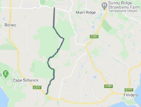
Greens Bush section: (8km)
Start Location: 4 Hyslops Road, Boneo
End Location: 1350 Boneo Road, Cape Schanck
The Greens Bush section of the Mornington Peninsula National Park is the largest area of remnant vegetation on the Mornington Peninsula. It was purchased from the Green Family and incorporated into the former Point Nepean National Park in 1989. This longer walk, an excellent way to see Greens Bush, is a link in the 26 km bush corridor from Dromana to Cape Schanck. There are several highlights along the trail - eucalypt forest mixed with spectacular stands of grasstree (the taller grasstrees may be over 200 years old), pockets of tea-tree thicket alive with birds, picturesque fern gullies and open grasslands.
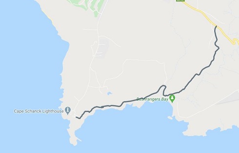
Bushrangers Bay section: (6km)
Start Location: 1350 Boneo Road, Cape Schanck
End Location: 420 Cape Schanck Road, Cape Schanck
The Bushrangers bay section of the Two Bays Walking Track travels from Boneo Road to Bushrangers Bay, and then on to Cape Schanck. The beautiful Bushrangers Bay comprises of a white sandy beach surrounded contrasted by dark and brooding basalt cliffs and headlands, and wild waves that often crash onto the jagged rocks guarding the entrance to the bay. Bushrangers Bay can be accessed from the car park in Boneo Road and picnic area (2.5km). This section of the Two Bays Walking Track travels along Main Creek and provides fine views and passes through shady Banksia groves as it winds its way down to Bushrangers Bay. Swimming is not recommended at this site as the beach is unpatrolled and often hazardous due to strong rips and large waves. Once arriving at Bushrangers Bay continue on towards the Cape Schanck to see some of the best coastal scenery near Melbourne. This section of the park was purchased from abutting farms in 1977.
Location
553 Point Nepean Road, Dromana 3936 Map
Web Links
→ Two Bays Walking Trail Guide (Parks Victoria)
")


")