Yarra State Park (Powelltown)

Walking Tracks in the Yarra State Park include
1. Ada Tree
Skill Level : Basic Fitness Level: Low
3.2km, 1.5 hrs return
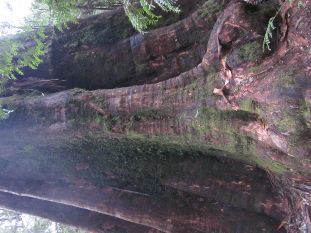
Journey through Myrtle Beech Rainforest to visit the Ada Tree, one of the largest known flowering trees in the world. Estimated at over 300 years old, the Ada Tree stands about 76m tall with a circumference of 15m measured at 1.5 m above ground level. The walk begins at the picnic area on Ada River Rd, following Island Creek to the Ada Tree. Return to the picnic area along the same route. If you have time, allow an extra 45 minutes to visit the New Federal Mill. Just continue 1.4km along the walking track at the Ada Tree.
2. Seven Acre Rock
Skill Level: Moderate Fitness Level: Average
1.2km, 30 mins return.

This short easy walk leads to Seven Acre Rock, a granite rock outcrop which provides commanding views of the Bunyip State Park, Western Port Bay and Port Phillip Bay on a clear day. The walk starts from the picnic area, 500 metres east of the junction of Learmonth Creek Road and Bunyip Road.
3. Reids Tramline
Skill Level: Basic Fitness Level: Average
6km, 2.5 hr return.
This walk follows the route of the historic tramline along which horses, and later, steam locomotives once hauled logs out of the forest. Begin at the picnic area opposite the DSE office and head east through the town. Pass the present day mill (look out for the original workers cottages above the mill) before picking up the original tramline at the eastern end of the town. Relics of the former mill and tramline can still be seen on this walk. Return along the same route or for a more challenging walk return via Big Bertha Track.
4. Spion Kopje
Skill Level: Moderate Fitness Level: Average
1km; 45 mins return.
A short, but slightly challenging walk to Spion Kopje lookout for views across the Tarago forest and Latrobe Valley. Approximately 15 km further on from Seven Acre Rock. The walk is signposted off Limberlost Road.
5. La La Falls
Skill Level: Moderate Fitness Level: Average
3.2km, 1.5 hrs return.
An enjoyable walk through tall Mountain Ash and lush tree ferns, before reaching the picturesque falls. Follow the signs from Park Road along Old Warburton Road to the start of the track on Irruka Road. The falls are said to be named after past landowner Leila Ward, whose guest house 'La La' (meaning Welcome Welcome) was located in the area.
6. Walk into History
33km, 2 days (one way)
The Walk into History follows some well preserved sections of the historic timber tramlines, past old mills and other relics of the early timber industry. Several creek crossings are required and a map of the area is essential. Due to the steepness of the High Lead section, the easiest way to do the walk is from Warburton or Big Pats Creek down to Powelltown.
The walk can be done in sections as detailed below.
6a. Warburton to Big Pats picnic area
6.5km, 2 hrs
Follow the Centenary Trail and Big Pat's Creek Rd to Big Pat's Creek Recreation Area.
6b. Big Pats picnic area to Starlings Gap
9km, 3.5 hrs
This section of the walk follows the Federal tramway and was constructed in 1933. Bush workers used to walk this section on a Sunday evening to be ready to begin work early Monday morning. On a Saturday afternoon however, some workers were known to have run the 9 km distance back to Big Pats Creek in time to make the weekly football match. Two sawdust heaps are all that remains to indicate the sites of the bush mills along this section. The first marks the site of Ezards sawmill, the second near Starlings Gap operated here until 1942. Starlings Gap provides a good place to rest, explore or even camp overnight before beginning the next section. When at Starlings Gap take a few minutes to visit the old winch and boiler located on a level track 200m past the toilet block.
6c. Starlings Gap to Ada No.2 Mill
8km, 3 hrs.
The journey to the Ada No2 Mill takes walkers through the Ada River Valley. In the first 2 km of this walk alone, nine trestle bridges were required to move timber from the mill to Starlings Gap. 7.5km into this section visitors reach the tramway junction known as the 'crossroads'. From this intersection you can head north to the New Ada Mill (2.8km return), or east to the Federal Mill (4.3km return) and Ada Tree (5.7km return) or continue the walk south to the Ada No.2 Mill.
6d. Ada No.2 Mill to Highlead Carpark
5.5km, 2.5 hrs.
This section leads visitors through forest that has seen the effects of both the Black Friday fires of 1939 and more recently the Ash Wednesday fires of 1983. The high lead marks the start of the most difficult section of the walk. The track drops 415 metres in 1600 metres, a grade of almost 1 in 4.
6e. Highlead Carpark to Powelltown picnic area
10.5km, 3 hrs.
The track follows the Latrobe River, crossing it numerous times before arriving at 'The Bump', the divide between the Little Yarra and Latrobe Rivers. This site is also known for 'The Bump Tunnel', an historic railway tunnel constructed in 1925. Spanning 313 metres in length, the tunnel was constructed to avoid winching up the existing steep inclines. Evidence of the tunnel can be seen along the walk. Here the track leaves the Latrobe and joins the Little Yarra River, where it makes its way back to Powelltown.
The number of sections per day depends on experience and fitness. Please obtain further information from DSE office. Map: The Ada River, Spion Kopje and Gladysdale sheets in the 1:25 000 VICMAP series cover this walk.
7. Richards Tramline
9km one way, 3 hrs

This walk, which follows an old logging tramline, winds it's way up the Mississippi Valley towards Starvation Creek. The track starts opposite the Big Pats Creek Picnic Area (800m along Smyth Creek Road from the bridge over Big Pats Creek) and finishes on Brahams Road. The first 2km of track, known as 'The Curves', gets its name from the series of bends constructed along the tramline to allow for a steady descent from Mississippi Fireline towards Big Pats Creek.
Picnic facilities are available at the Powelltown, Starlings Gap, Seven Acre Rock, Big Pats Creek, Latrobe River and Ada Tree picnic areas.
Getting There: From Melbourne, head out along the Maroondah Highway to Lilydale. Past Lilydale, turn right onto the Warburton Highway. At the township of Yarra Junction, turn right at the traffic lights and travel onto Powelltown in the heart of the Yarra State forest to the orientation and information board in the town centre or continue through the traffic lights to Warburton and visit the Water Wheel Tourist Information Centre.


")