Bunyip State Park (Tonimbuk)


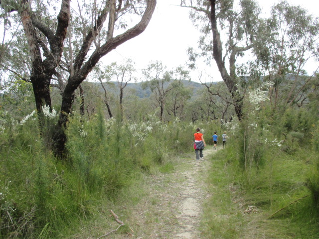
In February 2009, 45 per cent of Bunyip State Park was burnt by wildfire. Despite this dramatic event this park is once again an amazing escape where you can breathe fresh air and enjoy native plants and animals.
See a mosiac of green from heathland on river plains to Mountain Ash forest covering steep slopes. Whatever recreational pursuit you enjoy, Bunyip State Park provides opportunities for all.
Things to See and Do
Walking
Suggested short walks
1. Mortimer Nature Walk (1.2km, 45 minutes return, easy)
A self-guided nature walk introducing the plants, animals and other features of William Wallace and Diamond Creeks.
2. Lawson Falls Walk (750m, 40 minutes one-way, easy)
A short walk which takes you to the only waterfall within the park.
Longer walks
1. Buttongrass Nature Walk (3km, 1 hour return, easy)
A walk through a wet heathland area starting at Guide Track. Along this self-guided walk you can see a variety of flora including hakeas, wattles, tea-trees, mistletoe, swamp bush pea and button grass. For more information see the Buttongrass Nature Walk park note.
How to get to this walk: From Gembrook, drive east along the Gembrook-Tonimbuk Road. After 11 km turn right onto Camp Road. After 200m you will reach a small car park at the gated Guide Track.
2. Lawson Falls Circuit (5km, 2 hours return, moderate)
Start at Forest Road or Tea Tree Road in the east of the park.
3. Mortimer Circuit (9.5km, 4 hours return, moderate)
Starting from Mortimer Picnic Ground follow the Mortimer Nature Walk and turn into Steege Road. Tree Fern Track with its tall shady trees, is the next path to follow which crosses Link Road and then joins into Nichols Hut Track. The last leg of your journey is along Silvertop Ridge Track and Ferres Track, and before you know it, you are back at Mortimer Picnic Ground.
4. Weatherhead Range Circuit (10km, 4 hours return, moderate)
Start at Buttongrass Nature Walk and follow Camp Road. Turn left into Guides Track for the climb up the Weatherhead Range, then turn right into Luptons Track. Turn left into Avards Track and cross over Tynong North Road, heading west up Pooley Road. Take Sandpit Ridge Track through a heathy woodland community and head back to the start via Cannibal Creek Track, Camp Road and Buttongrass Nature Trail.
Camping
There is a designated area with basic facilities at Nash Creek.
History
The first people to live in the area were the Balluk-William clan of the Woiworung (Yarra Yarra) Aboriginal people.
The first Europeans to visit the district were the miners and prospectors, in the mid 1850s, but the promise of gold elsewhere lured them away.
The Bunyip State Park area soon became popular for its timber. The Mortimer Mill of 1898, located at the present site of Mortimer Picnic Ground, is thought to be the earliest timber mill in the park.
A narrow-gauge rail line from Ferntree Gully to Gembrook was completed in 1900. Tramways were then used to take timber from the bush sawmills to the Gembrook yard. Throughout the park are remnants of timber tramways and large sawdust heaps. A large sawdust heap can be seen opposite Dyers Picnic Ground. Forest harvesting ceased in 1990 and the park was declared in 1992.
The Legend of the Bunyip
Beware of the Bunyip, a dark furry animal with a round face, small ears and fiery eyes that glow in the dark!
According to the Aboriginal people, the Bunyip or "Buneep" (as spelt on early maps which show the river, first cattle run and township) is a spirit that punishes bad people.
Local Aboriginal people believed the Bunyip lived in the swamps of the Bunyip River, and therefore avoided the area. Many early settlers, believing this story, never pitched their tents near a 'Bunyip hole'. People were also careful not to make ripples when collecting water. This upset the Bunyip.
Access for Dogs:
Dogs are not permitted but are allowed on a lead within Kurth Kiln Regional Park.
Location and Access
Bunyip State Park is only 65km east of Melbourne. You can get there via Gembrook, from the Princes Freeway, or from Woori Yallock. When approaching from Gembrook or Woori Yallock, trail bike riders and four wheel drivers are advised to enter the park via Beenak East Road and Black Snake Creek Road for access to four wheel drive tracks and trail bike unloading areas.
Review:
We went on the 3 km Buttongrass Nature Walk which seems to be the best and most documented walk in the park. There is about three kilometres of gravel road to reach the start of this walk from Gembrook.
Make sure you use the Park Notes (see below) since each point of interest corresponds to a numbered post on the walk. In spring there are a lot of wildflowers on the walk and it is very pleasant. The track is well formed, although a little wet in places. There are a number of seats along the path to have a rest. The walk took about an hour and there are only gradual slopes.
Photos:
Location
Cnr Camp Road and Guide Track, Tonimbuk 3815 Map
Web Links
→ Bunyip State Park (Parks Victoria)
→ Bunyip State Park - Button-grass Nature Walk (PDF)
→ Bunyip State Park Map (PDF)
→ Button Grass Walk (Bunyip State Park) (Walking Maps)
→ Friends of Bunyip State Park on Facebook
→ The Best Family Activities in the Dandenong Ranges
→ Bunyip State Park - Four wheel driving and trail bikes - Park note (PDF)
→ Bunyip State Park - Heritage Horse Trail (PDF)
→ Bunyip State Park - Park note (PDF)


