Seymour - Goulburn River Trail Walk


A 3.4km (one-way) multi-purpose trail suitable for all abilities alongside the Goulburn River.
The Trail provides the chance to view some lovely scenery, historic sites and native wildlife. Viewing platforms, seating and picnic tables are located throughout the walk. There are also many local eateries within walking distance.
Map of Route
Interactive Map
You cannot access the track from where Emily Street crosses the Goulburn River. However, there are several entrance points and ample car parking options through the middle of the track.
Points of interest along the route are:
1. Vineyard
The first vines were planted in 1968. Grapes were processed on-site for the first time in 1976. The winery was originally known as Glengariff Winery. Access via #1 Emily Street.
2. Goulburn River Bridge
Historical bridge which was the first bridge over the Goulburn River. It was built by Patrick Hanna in 1862-63. It was a low level bridge and Hanna had a toll gate at the foot of Manse Hill until 1867 when it was purchased by the Government and tolls were collected for the Roads Board until 1873. A new bridge was constructed in 1892 and was considerably strengthened during the Second World War to carry heavy army vehicles and equipment. In 1967 a new bridge was built across the Goulburn as the Hume Highway crossing was moved upstream. The old bridge continued to serve as the crossing for traffic to Puckapunyal until the building of the Hume Freeway in 1982.
3. Car park
Car park and entry point. There are some tables and seats here.
4. Old Rowing Course
Seymour's Rowing Club Several rowing clubs have operated from this area of the river since 1859. Boatsheds were erected near this site in 1899. The boathouse was "capable of holding six large racing boats, two handsome gigs (long light rowboats) and a handsomely designed flag" reported the Seymour Telegraph.
From 1899 until the First World War the area of the river near here was used as the Rowing Course for the Annual Rowing Regatta. The boatsheds were washed away in the great flood of 1916 and the Club was not revived after World War I.
5. Car park
Car park and entry point (accessed via Manners Street)
6. Car Park
Car park and entry point (accessed via Manners Street)
7. Boat Ramp
There is a boat ramp located in Lions Park
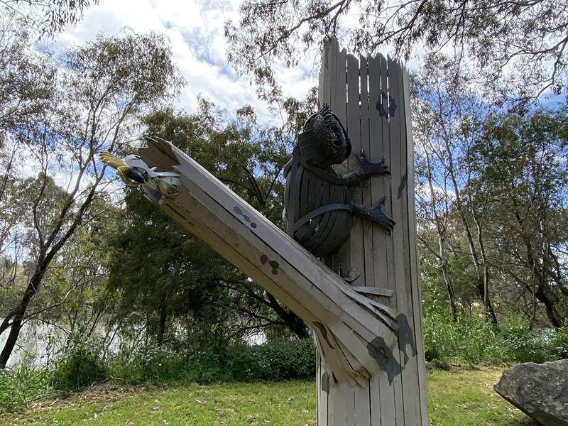
8. New Crossings Place (Lions Park)
During 1839 the Sydney to Melbourne mailman began crossing the Goulburn River at a ford near this site, replacing the old crossing place at Mitchellstown. By August a punt was in operation here and in December 1839 John Clark established an inn near the present Royal Hotel. He was Seymour's first townsmen making Seymour one of Victoria's oldest settlements.
This park has facilities for a great day out - shelter with two tables, BBQs, unshaded tables, water tap and grassy area. Lookout for the cute sculpture of a koala and cockatoo.
9. Fishing Platform
Viewpoint
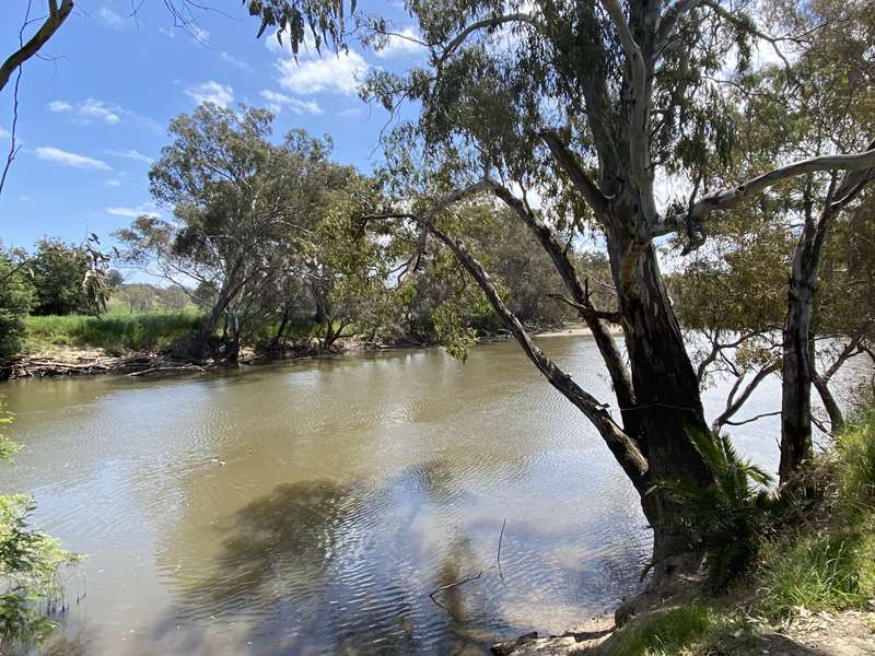
Eucalyptus (gum trees) such as River Red Gums and Manna Gums, provide a source of food and a home for the Koala. Solitary animals, koalas are regularly seen sleeping in the large old Red Gums of this reserve. Look up; you may notice a koala gazing down at you from its tree top perches.
Much of the river land around Seymour has been cleared for agriculture or development, however a few small patches of rough vegetation have been preserved as valuable habitat. The Goulburn River Walking Trail is situated along some of these habitat areas and walkers may see Swamp Wallabies hiding in the undergrowth. Wallabies come out at dusk to feed on grasses, shrubs and ferns. Wallabies are generally solitary animals, although groups of as many as five wallabies have been sighted in the habitat areas of this reserve. Walkers are reminded to keep their dogs under effective control, to protect these shy creatures.
10. Car Park
Car park and entry point
11. Old Swimming Pool
The posts in the river near here indicate the site of the old swimming pool. For many years the residents of Seymour swam here in the Goulburn River in the Old Town Swimming Pool. A swimming club was formed in 1909 and club activities continued till the 1940s.
Railway sleepers were placed along the bank for tiered seating and a diving tower was erected. Posts in the river marked the boundaries of the pool and boards were attached to stop swimmers being washed downstream. A diving tower was a popular attraction at the pool.
One hot night in 1933 a huge crowd of about 3,000 people gathered to witness a swimming and diving exhibition by two United States Olympians. Local swimmers competed in a handicap race and other leading Australian and Victorian swimmers gave demonstrations.
12. Army Tank
Located opposite the Seymour Visitor Information Centre.
13. Street parking
Street parking and entry to the track is available on Robert Street.
14. Seymour Visitor Information Centre
Drop in to the Seymour Visitor Information Centre and learn more about this walking track and other local gems.
15. Public toilets
Located next to the Seymour Visitor Information Centre
16. The Goulburn Brewery
In 1869 Henry Bolton, in partnership with John Flynn and James Tierney established the River Goulburn Brewery on the bank of the river at the end of Bolton Street. With W. Wright as the brewer, 100 hogsheads of beer were produced each week when the brewery was at its peak. This is almost 25,000 litres of beer.
Later owners were Percival Renou, Henry Bones and Sons, and Siddall and Co. The-brewery closed in 1898.
The buildings were later converted into a butter factory by Messrs. Boddy and Partridge. Much of the site has now been washed away by the river.
As early as 1839 flocks of-sheep belonging to a Mr. Whitehead were found to be camped near this spot and this appears to be the origin of the name Whitehead's Creek. The first bridge across the creek was built by the Welsh in 1849. The stone for the construction of the Royal Hotel wad quarried from Whiteheads Creek in 1848.
Soon after the establishment of police barracks in Seymour in 1841 the position of the Police Paddocks was located north of Whitehead's Creek. The police station remained on a site near the end of Bolton Street until 1865 when the log lock-up was moved to the site of the present police station.
In 1886 an area of land south-west of the Police Paddock at the junction of Whitehead's Creek and the Goulburn River was reserved as a Public Park which became known as Seymour Town Park. In 1905 this park was sold due to the development of a new park known today as Kings Park.
At this point there is a shelter with BBQ and unshaded table.
Access for Dogs:
Dogs are permitted on leash.
Review:
A lovely, easy walk along a well-defined track beside the Goulburn River with a number of places to stop for a break along the route. You can optionally return along Emily Street which has some lovely historical buildings (see the Seymour Heritage Walk).
Photos:
Location
1 Emily Street, Seymour 3660 Map
Web Links
→ Goulburn River Trail, Seymour (Walking Maps)
")


")