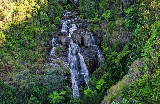
Kinglake West - Masons Falls


Masons Falls Picnic Area has gas barbecues, tables, shelter and toilets. There are several short walks that can be combined to form a full day walk of around 13km. Masons Falls walk (700 metres one way) leads to the Masons Falls viewing platform.
Masons Falls Picnic Area - Enjoy a picnic in the beautiful surroundings of the Masons Falls Picnic Area. Set among towering gums, large shelters, lots of tables, free gas barbecues and toilets make this the perfect place for a social gathering. You can also bring your own portable gas barbecue however solid fuel barbecues are not permitted.
Explore how the forest and fern gullies have regrown since the Black Saturday bushfire with several short walks that can also be combined to form a full day walk of around 13km. Masons Falls Walk (700 metres one way) leads to the spectacular Masons Falls lookout.
Blackwood Picnic Area - With picnic facilities set in a grassy clearing at the entrance to the Sugarloaf Block, Blackwood Picnic Area is the perfect place to take a break when exploring Mt Sugarloaf and Masons Falls.
How to Get There from Melbourne
Take the National Park Road turnoff on the Whittlesea - Kinglake Road between Kinglake West and Pheasant Creek.
Access for Dogs:
Dogs are not allowed in Kinglake National Park.
Review:
The parking area has four sheltered BBQs, two shelters with 3 - 4 tables, six unshaded tables, toilets and water tap (not for drinking). Note that solid fuel fires are not permitted although you can bring a gas BBQ.
In 2009 96% of the 23,210 hectare park was affected by the Black Saturday fire. The vegetation has had a lot of regrowth and the facilities and trails have been re-constructed.
There are four different walking tracks with walks ranging in length from 10 minutes to 45 minutes. They can be connected together to form longer walks also. The Lyrebird circuit walk is 500m (10 minutes) and begins and ends at the Mason Falls Picnic Area. The track is designed for people of limited mobility and the shady trail winds its way through some of the park's oldest trees. The Boundary Track is 2.4 km (one way) and follows the park boundary. Goodenia Track is 750m one way (15 minutes) and climbs slowly to meet the Boundary Track. In Spring, the Spiny Hakeas flower provides a sweet pungent aroma.
The track to Masons Falls is 700m one way (20 minutes) over a well formed path which provides scenic views of the falls and the gorge downstream. The falls flow down a big hill in a series of cascades. The falls are viewed from a viewing platform and it is not possible to walk to the base or top of the falls.
The falls generally flow throughout the year and are most spectacular after heavy rain.
There is a good chance of seeing a variety of birds such as wrens and rosellas and if you are lucky you might spot a lyrebird.
Photos:
Location
National Park Road, Kinglake West 3757 Map
Web Links
→ Kinglake National Park (Parks Victoria)
→ Kinglake National Park Visitor Guide (PDF)
→ The Best Family Activities in the Yarra Valley
→ The Best Waterfalls in Melbourne and Victoria for Family Visits
→ Kinglake National Park Heritage Story (PDF)
→ Kinglake National Park Map (PDF)


