Eildon - Snobs Creek Falls


Snobs Creek Falls offer spectacular views as they drop more than 100 metres over a series of rocky outcrops. The pristine waters of Snobs Creek are an important supply to the Snobs Creek Fish Hatchery six kilometres below. A short walk from the carpark to the base of the Falls includes a number of observation platforms.
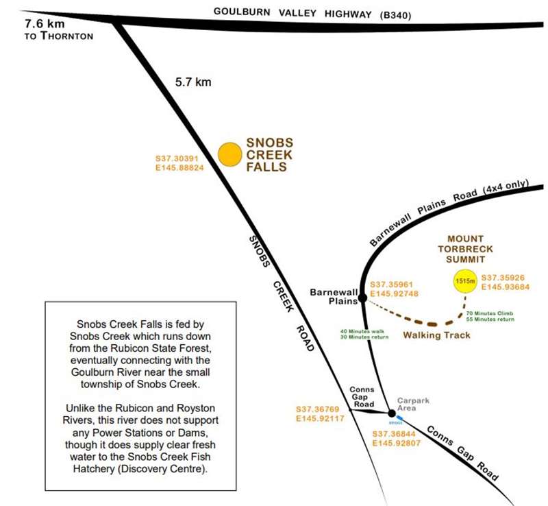
Snobs Creek Falls is located 5.7 km south of the intersection of the Goulburn Valley Highway and Snobs Creek Road. The road is only sealed for the first 3.5 km.
The Falls are divided into the Cascades (located 200 metres above the main Falls) and the Upper and Lower Snobs Creek Falls. The current steel viewing platform was opened in 2012 at the Upper Falls and allows for viewing from the top of the Falls only. The view (above) is no longer accessible. Currently there is no access to the Lower Falls, which has been inaccessible since the mid 1960s. The pathway from the carpark to the Upper Falls takes you along the creek's edge to the top of the Falls. From here the water drops a staggering 110 metres to the river below.
Waterfalls are extremely dangerous and lives have been lost at this location. The stairs and pathway can be slippery when wet, so extreme caution should be taken. Always keep within the provided barriers. The pathways are of mild grade and take only a few minutes to walk. Hand rails are provided along the full length of both pathways.
History - In the early 1860's, Snobs Creek was then known as Cataract Creek but was later changed to 'Snobs' after 'Black' Brooks, a West Indian man who operated a bootmakers shop in close proximity to the creek and present highway. Snob is an old English term used for bootmaker or boot repairer.
Flora and Fauna - The vegetation surrounding the Falls contains a wide variety of ferns, mosses and fungi indigenous to the moist eucalypt forest environment created by the Falls. Lyrebirds can be observed and heard in the forest area surrounding the Falls, along with other native animals such as koalas, wallabies, wombats and brush tail, ring tail and greater glider possums.
Attractions - Just to the east of the attached map (refer Forests Note FS0054 - Mount Torbreck Walking Track) lies Mt Torbreck, rising to an altitude of 1516 m. The walk to the summit is a 2 km walk from the Barnewall Plains visitor area on Barnewall Plains Rd. The walk takes approximately 2 hours return, and is steep and rocky in sections. On a clear day, views from around the summit are breathtaking and well worth the long climb. A rock cairn marks the summit location. Access to the beginning of the walk is restricted between mid June and late October, when Barnewall Plains Road is closed to within a 10-minute walk of Barnewall Plains.
Morris Lookout is a short drive from Snobs Creek Falls and provides stunning views of the surrounding area, including the townships of Thornton and Eildon.
Kendalls Camping and Day Visitor Area - The forest surrounding the Falls has many opportunities for camping, including two popular, large camping areas, Kendalls A and Kendalls B camping and day visitor areas. They are located on the western bank of the Rubicon River on Rubicon River Rd. A 1.5 km pedestrian and bicycle track connects the two Kendalls camping areas. The track is an easy walk and winds through a range of picturesque settings.
Seasonal Road Closures - Some roads within the forest are closed each year between
mid June and late October, to protect track surfaces and the environment, and for public safety. Road closures may be extended beyond these dates, depending on weather conditions. These closures are usually enforced by a gate or sign. Contact DSE for more information on road closures.
Location and access - Snobs Creek Falls are 160 km north-east of Melbourne situated in the foothills of Rubicon State forest. Follow the Maroondah Highway to Taggerty, turn right onto the Taggerty-Thornton Rd and continue through to Thornton. Turn right onto the Goulburn Valley Highway, then right again onto Snobs Creek Rd. The Falls are approximately 6 km along Snobs Creek Rd.
Directions
1. Travel to the corner of Goulburn Valley Highway and Snobs Creek Road between Eildon and Thornton.
2. Travel 5.5 km to the Snobs Creek Fall's car park on the left.
3. Walk down the stairs to the Upper Falls area or to the Cascades.
Photos:
Review:
The first 3 km of Snobs Creek Road after turning off from the Goulburn Valley Highway are asphalt and the last 3 km are gravel.
From the car park on the side of the road there is a 25m walk (38 concrete steps) down to a viewing platform overlooking the cascades which is a series of short drops.
However, the cascades are just a warm-up for the main event. There is another concrete path which is 100m long with 110 steps which passes through some temperate rainforest and opens out to the top of a spectacular gully. The main waterfall has a lookout platform perched out into space with great views of the water cascading down the rock face. There was lots of water in February when we visited. The creek above didn't seem to be flowing that fast but a lot of water tumbles over the falls to a level area below and then drops further down the gully out of site.
Location
Snobs Creek Road, Eildon 3713 Map
Web Links
→ Map of Snobs Creek Falls (PDF)
→ Snobs Creek Falls (World of Waterfalls)
→ The Best Waterfalls in Melbourne and Victoria for Family Visits
")


")